Buna River-Velipoja Protected Landscape
| Buna River-Velipoja Protected Landscape | |
|---|---|
|
IUCN category V (protected landscape/seascape) | |
 | |
| Location | Shkodër County |
| Nearest city | Shkodër |
| Coordinates | 41°56′6″N 19°27′1″E / 41.93500°N 19.45028°ECoordinates: 41°56′6″N 19°27′1″E / 41.93500°N 19.45028°E |
| Area | 23,027 hectares (230.27 km2) |
| Established | 2 November 2005[1][2] |
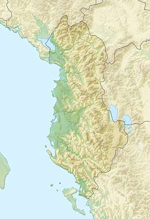
The Buna River-Velipoja Protected Landscape (Albanian: Peisazh i Mbrojtur Lumi Buna-Velipojë) is a protected landscape area in northwestern Albania, encompassing the estuary of Drin, the lagoon of Viluni, the river of Buna with its estuary, and the gulf of Drin that runs across the city of Velipojë alongside the Adriatic Sea.
The International Union for Conservation of Nature (IUCN) has listed the park as Category V and has been further recognized as a wetland of international importance by designation under the Ramsar Convention.[3][4][5][6] Being part of the European Green Belt, the landscape is also an Important Bird and Plant Area, because it supports extraordinary threatened and endemic bird and plant species.[7][8]
Stretching between the Dinaric Alps and the Mediterranean Sea, the river of Buna is an outflow of the lake of Shkodër, the largest lake in Southern and Southeastern Europe, which ultimately runs through the river until it drains into the Adriatic Sea. The landscape is an essential migration corridor at that season for hundreds of species between the Adriatic Sea and the innland.[9]
The region is specifically marked by a relatively flat and shallow landscape supplied with alluvial forests, dry grasslands, marsh and shrublands, estuaries, freshwater wetlands and beaches. The climate of the landscape is strongly under the influence of the Adriatic Sea in the west and the Albanian Alps in the north. Under the Köppen climate classification, it experiences a mediterranean climate characterized by warm to dry-hot summers and mild-wet to rainy winters.[10]
An extraordinary variety of wildlife species live in the region.[9] The golden jackal occurs in the woodlands and marshes of the riverine floodplains. The coastline, dotted with sand dunes, offers great feeding opportunities for the brown bear. The common bottlenose dolphin has been identified within its waters and prefers the coastal waters and river deltas.[11] Two species are outstanding though, the green sea and loggerhead sea turtle which nest in the beaches of the gulf.[12][13] The dalmatian pelican uses the salt pans around the region as feeding habitat during autumn.[14]
See also
References
- ↑ Fletorja Zyrtare e Republikës së Shqipërisë. "FLETORJA ZYRTARE E REPUBLIKËS SË SHQIPËRISË" (PDF). qbz.gov.al (in Albanian). p. 3-6.
- ↑ "Zonat e mbrojtura detare e bregdetare në Shqipëri" (PDF). al.undp.org (in Albanian & English). p. 9.
- ↑ The Mediterranean Wetlands Initiative. "Buna river project launch gathers wide support in Albania". medwet.org.
- ↑ Ministria e Mjedisit e Shqipërisë. "RRJETI I ZONAVE TË MBROJTURA NË SHQIPËRI" (PDF). cbd.int (in Albanian). Tirana. pp. 1–3.
- ↑ IUCN. "Discover the Buna River Protected Landscape". iucn.org.
- ↑ Ramsar. "Albania" (in English and Spanish). Ramsar Convention. p. 1.
- ↑ BirdLife International. "Velipoja". datazone.birdlife.org (in Englisch).
- ↑ IUCN, World Wide Fund for Nature, Plantlife. "Important Plant Areas of the south and east Mediterranean region" (PDF). portals.iucn.org. p. 75.
- 1 2 "Rapid assessment of the Ecological Value of the Bojana-Buna Delta (Albania / Montenegro)" (PDF). researchgate.net. pp. 1–104.
- ↑ Giuliano Fanelli, Michele De Sanctis, Ermelinda Gjeta, Alfred Mullaj and Fabio Attorre (2015). "THE VEGETATION OF THE BUNA RIVER PROTECTED LANDSCAPE (ALBANIA)" (PDF). ojs.zrc-sazu.si. pp. 1–46.
- ↑ "Inland Observation of Common Bottlenose Dolphins Tursiops Truncatus (Montagu, 1821) in the Delta of the Bojana/Buna River, Albania and Montenegro" (PDF). dlib.si. pp. 1–4.
- ↑ "Monitoring and Conservation of Important Sea Turtle Feeding Grounds in the Patok Area of Albania 2008‐2010 PROJECT REPORT" (PDF). vliz.be. pp. 1–68.
- ↑ "Loggerhead turtles (Caretta caretta) foraging at Drini Bay in Northern Albania: Genetic characterisation reveals new haplotypes" (PDF). fupress.net. Tirana, Albania. pp. 1–8.
- ↑ IUCN, European Green Belt. "The Green Belt of Europe From Vision to Reality" (PDF). europeangreenbelt.org. pp. 82–83.