Buka, Papua New Guinea
| Buka | |
|---|---|
| Town | |
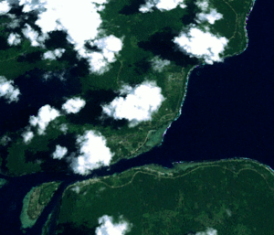 Buka Township, with Sohano Island (Bottom left) and Buka Airport | |
 Buka Location in Papua New Guinea | |
| Coordinates: 5°25′19″S 154°40′22″E / 5.42194°S 154.67278°E | |
| Country |
|
| Province | Bougainville Province |
| District | North Bougainville District |
| Time zone | UTC+10 (AEST) |
| Main languages | Nasioi, Rorovana |
| Climate | Af |
Buka is located on the southern coast of Buka Island, in the Autonomous Region of Bougainville, in eastern Papua New Guinea (country).
It is the capital of the North Bougainville District, and the interim provincial capital of the Autonomous Region of Bougainville.'
It contains Our Lady of the Assumption Cathedral.
Geography
The city and Buka Island are separated from the northern tip of Bougainville Island by the Buka Passage. Both islands are in the northern Solomon Islands archipelago, and the only major ones not within the nation of Solomon Islands. The city is served by Buka Airport.
History
Buka was the capital of the Bougainville Province, during the 1990s Bougainville Civil War. The former, or "proper" capital of Bougainville, Arawa, was all but destroyed in 1990 as tensions reached a critical level in a civil uprising, which ended in 1997.
Provincial capitals of Papua New Guinea | ||
|---|---|---|
Coordinates: 5°25′19″S 154°40′22″E / 5.42194°S 154.67278°E