Brownell, Kansas
| Brownell, Kansas | |
|---|---|
| City | |
 Location within Ness County and Kansas | |
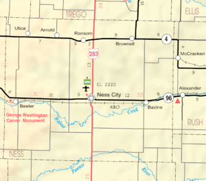 KDOT map of Ness County (legend) | |
| Coordinates: 38°38′23″N 99°44′45″W / 38.63972°N 99.74583°WCoordinates: 38°38′23″N 99°44′45″W / 38.63972°N 99.74583°W | |
| Country | United States |
| State | Kansas |
| County | Ness |
| Area[1] | |
| • Total | 0.20 sq mi (0.52 km2) |
| • Land | 0.20 sq mi (0.52 km2) |
| • Water | 0 sq mi (0 km2) |
| Elevation | 2,415 ft (736 m) |
| Population (2010)[2] | |
| • Total | 29 |
| • Estimate (2016)[3] | 28 |
| • Density | 150/sq mi (56/km2) |
| Time zone | UTC-6 (Central (CST)) |
| • Summer (DST) | UTC-5 (CDT) |
| ZIP code | 67521 |
| Area code | 785 |
| FIPS code | 20-08675 [4] |
| GNIS feature ID | 0475380 [5] |
| Website | City website |
Brownell is a city in Ness County, Kansas, United States. As of the 2010 census, the city population was 29.[6]
History
Brownell was a station on the Missouri Pacific Railroad.[7] The community was named for one Mr. Brownell, a railroad official.[8]
The first post office in Brownell was established in 1880, but the post office was called Vansburgh until 1888.[9]
Geography
Brownell is located at 38°38′23″N 99°44′45″W / 38.63972°N 99.74583°W (38.639630, -99.745801).[10] According to the United States Census Bureau, the city has a total area of 0.20 square miles (0.52 km2), all land.[1]
Climate
The climate in this area is characterized by hot, humid summers and generally mild to cool winters. According to the Köppen Climate Classification system, Brownell has a humid subtropical climate, abbreviated "Cfa" on climate maps.[11]
Demographics
| Historical population | |||
|---|---|---|---|
| Census | Pop. | %± | |
| 1930 | 207 | — | |
| 1940 | 162 | −21.7% | |
| 1950 | 211 | 30.2% | |
| 1960 | 118 | −44.1% | |
| 1970 | 98 | −16.9% | |
| 1980 | 92 | −6.1% | |
| 1990 | 44 | −52.2% | |
| 2000 | 48 | 9.1% | |
| 2010 | 29 | −39.6% | |
| Est. 2016 | 28 | [3] | −3.4% |
| U.S. Decennial Census | |||
2010 census
As of the census[2] of 2010, there were 29 people, 16 households, and 8 families residing in the city. The population density was 145.0 inhabitants per square mile (56.0/km2). There were 38 housing units at an average density of 190.0 per square mile (73.4/km2). The racial makeup of the city was 100.0% White.
There were 16 households of which 12.5% had children under the age of 18 living with them, 50.0% were married couples living together, and 50.0% were non-families. 50.0% of all households were made up of individuals and 18.8% had someone living alone who was 65 years of age or older. The average household size was 1.81 and the average family size was 2.63.
The median age in the city was 59.5 years. 17.2% of residents were under the age of 18; 0.0% were between the ages of 18 and 24; 10.3% were from 25 to 44; 37.8% were from 45 to 64; and 34.5% were 65 years of age or older. The gender makeup of the city was 58.6% male and 41.4% female.
2000 census
As of the census[4] of 2000, there were 48 people, 23 households, and 14 families residing in the city. The population density was 246.7 people per square mile (97.5/km²). There were 44 housing units at an average density of 226.1 per square mile (89.4/km²). The racial makeup of the city was 97.92% White, and 2.08% from two or more races.
There were 23 households out of which 13.0% had children under the age of 18 living with them, 56.5% were married couples living together, and 34.8% were non-families. 30.4% of all households were made up of individuals and 17.4% had someone living alone who was 65 years of age or older. The average household size was 2.09 and the average family size was 2.53.
In the city, the population was spread out with 14.6% under the age of 18, 8.3% from 18 to 24, 10.4% from 25 to 44, 35.4% from 45 to 64, and 31.3% who were 65 years of age or older. The median age was 51 years. For every 100 females, there were 152.6 males. For every 100 females age 18 and over, there were 127.8 males.
The median income for a household in the city was $36,250, and the median income for a family was $43,750. Males had a median income of $25,000 versus $28,750 for females. The per capita income for the city was $14,765. There were 23.5% of families and 28.8% of the population living below the poverty line, including 57.1% of under eighteens and none of those over 64.
Education
Western Plains USD 106 serves Arnold, Bazine, Brownell, Ransom and Utica.[12] The Western Plains High School mascot is Bobcats.
Parks and Recreation
Notable people
- Chief Hogsett, Major League Baseball pitcher
References
- 1 2 "US Gazetteer files 2010". United States Census Bureau. Archived from the original on 2012-07-14. Retrieved 2012-07-06.
- 1 2 "American FactFinder". United States Census Bureau. Retrieved 2012-07-06.
- 1 2 "Population and Housing Unit Estimates". Retrieved June 9, 2017.
- 1 2 "American FactFinder". United States Census Bureau. Archived from the original on 2013-09-11. Retrieved 2008-01-31.
- ↑ "US Board on Geographic Names". United States Geological Survey. 2007-10-25. Retrieved 2008-01-31.
- ↑ "2010 City Population and Housing Occupancy Status". U.S. Census Bureau. Archived from the original on July 21, 2011. Retrieved September 13, 2011.
- ↑ Blackmar, Frank Wilson (1912). Kansas: A Cyclopedia of State History, Embracing Events, Institutions, Industries, Counties, Cities, Towns, Prominent Persons, Etc. Standard Publishing Company. p. 245.
- ↑ "Profile for Brownell, Kansas". ePodunk. Retrieved 19 June 2014.
- ↑ "Kansas Post Offices, 1828-1961". Kansas Historical Society. Retrieved 19 June 2014.
- ↑ "US Gazetteer files: 2010, 2000, and 1990". United States Census Bureau. 2011-02-12. Retrieved 2011-04-23.
- ↑ Climate Summary for Brownell, Kansas
- ↑ "Western Plains". USD 106. Retrieved 1 January 2017.
External links
- City
- Schools
- USD 106, local school district
- Maps
- Brownell City Map, KDOT
Municipalities and communities of Ness County, Kansas, United States | ||
|---|---|---|
| Cities | 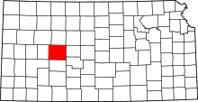 | |
| Unincorporated communities | ||