British Empire Range
| British Empire Range | |
|---|---|
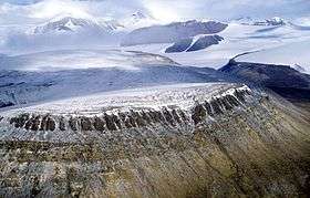 British Empire Range, to the north of Tanquary Fiord | |
| Highest point | |
| Peak | Barbeau Peak |
| Elevation | 2,616 m (8,583 ft) |
| Coordinates | 81°54′30″N 75°01′30″W / 81.90833°N 75.02500°W |
| Geography | |
 | |
| Country | Canada |
| Territory | Nunavut |
| Range coordinates | 82°21′N 77°30′W / 82.350°N 77.500°WCoordinates: 82°21′N 77°30′W / 82.350°N 77.500°W |
The British Empire Range is a mountain range on Ellesmere Island in Nunavut, Canada. The range is one of the most northern ranges in the world[1] and the Arctic Cordillera, surpassed only by the Challenger Mountains[2] which lies immediately to the northwest and the United States Range[3] slightly further east. The highest mountain in the range is Barbeau Peak.
The range was named by Gordon Noel Humphreys during the Oxford University Ellesmere Land Expedition. Edward Shackleton, also a member of the party, claimed, in 1937, that Humphreys had done so because he was "a great imperialist".
Peaks of the range include:
| Peak | metres | feet |
|---|---|---|
| Barbeau Peak | 2,616 | 8,583 |
| Mount Whisler | 2,500 | 8,202 |
| Mount Oxford | 2,210 | 7,250 |
| Arrowhead Mountain | 1,860 | 6,102 |
| Highpointer Peak | 1,585 | 5,200 |
References
- ↑ British Empire Range at the Atlas of Canada
- ↑ The Challenger Mountains at the Atlas of Canada
- ↑ The United States Range at the Atlas of Canada
- Geographical Names of the Ellesmere Island National Park Reserve and Vicinity by Geoffrey Hattersley-Smith (1998) ISBN 0-919034-96-9
This article is issued from
Wikipedia.
The text is licensed under Creative Commons - Attribution - Sharealike.
Additional terms may apply for the media files.