Kaumajet Mountains
| Kaumajet Mountains | |
|---|---|
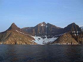 Bishop's Mitre in the Kaumajet Mountains | |
| Highest point | |
| Peak | Brave Mountain |
| Elevation | 1,300 m (4,300 ft) |
| Coordinates | 57°52′59.9″N 62°01′59.9″W / 57.883306°N 62.033306°W |
| Geography | |
| Country | Canada |
| State/Province | Labrador |
| Range coordinates | 57°48′N 61°51′W / 57.800°N 61.850°WCoordinates: 57°48′N 61°51′W / 57.800°N 61.850°W |
| Parent range | Arctic Cordillera |
The Kaumajet Mountains are a dramatic compact mountain range rising directly out of the sea on the northern Labrador coast. The mountain range has one 4,000-foot (1,200 m) peak, the highest island peak on the east coast of North America between the Caribbean and Hudson Strait, and several peaks with very high prominence. The highest mountain in the Kaumajet Mountains is Brave Mountain at 1,300 m (4,265 ft).
| Rank | Name | m | ft |
|---|---|---|---|
| 1 | Brave Mountain | 1300 | 4265 |
| 2 | Bishop's Mitre | 1113 | 3652 |
| 3 | The Finger | 1006+ | 3300+ |
| 4 | Peak 3300 (14F/13) | 1006+ | 3300+ |
| 5 | Cod Island High Point | 914+ | 3000+ |
| 6 | Cod Island Peak | 823+ | 2700+ |
| 7 | Cod Island Peak | 792+ | 2600+ |
| 8 | Drachart Island High Point | 726+ | 2500+ |
See also
External links
- "Kaumajet Mountains". Peakbagger.com.
This article is issued from
Wikipedia.
The text is licensed under Creative Commons - Attribution - Sharealike.
Additional terms may apply for the media files.