Brisco, Indiana
| Brisco, Indiana | |
|---|---|
| Ghost town | |
 Looking east toward the site of Brisco | |
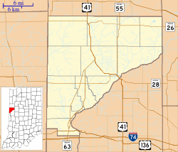 Brisco Brisco's location in Warren County | |
| Coordinates: 40°24′40″N 87°21′30″W / 40.41111°N 87.35833°WCoordinates: 40°24′40″N 87°21′30″W / 40.41111°N 87.35833°W | |
| Country | United States |
| State | Indiana |
| County | Warren |
| Township | Pine |
| Elevation[1] | 679 ft (207 m) |
| Time zone | UTC-5 (Eastern (EST)) |
| • Summer (DST) | UTC-4 (EDT) |
| ZIP code | 47993 |
| Area code(s) | 765 |
| GNIS feature ID | 431533 |
Brisco (or Briscoe) was a small town in Pine Township, Warren County, in the U.S. state of Indiana. It began in the 1850s and gained a one-room school in 1856, which operated until 1929. In 1930 the school building became a general store run for more than 50 years by local resident Jim Marquess. Never more than a tiny hamlet, Brisco almost entirely disappeared during the 20th century and now no longer appears on county maps, though the USGS cites it,[2] and a cemetery northeast of town still bears the name.
Geography
Brisco is located along Old US 41, about a quarter mile east of the intersection of County Road 650 North with U.S. Route 41 and roughly 9 miles north-northwest of the county seat of Williamsport. Mud Pine Creek flows just east of the site.
References
- ↑ "US Board on Geographic Names". United States Geological Survey. October 25, 2007. Retrieved 2016-07-10.
- ↑ "Brisco, Indiana". Geographic Names Information System. United States Geological Survey. Retrieved 2010-08-22.
- Warren County Historical Society. A History of Warren County, Indiana (175th Anniversary Edition) (2002).
Municipalities and communities of Warren County, Indiana, United States | ||
|---|---|---|
| Towns | ||
| Townships | ||
| Unincorporated communities | ||
| Ghost towns | ||