Baltimore, Indiana
| Baltimore, Indiana | |
|---|---|
| Ghost town | |
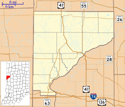 Baltimore Location in Warren County | |
| Coordinates: 40°09′57″N 87°26′31″W / 40.16583°N 87.44194°WCoordinates: 40°09′57″N 87°26′31″W / 40.16583°N 87.44194°W | |
| Country | United States |
| State | Indiana |
| County | Warren |
| Township | Mound |
| Time zone | UTC-5 (Eastern (EST)) |
| • Summer (DST) | UTC-4 (EDT) |
| ZIP code | 47932 |
| Area code(s) | 765 |
Baltimore was a small town built on the western banks of the Wabash River in Mound Township, Warren County, in the U.S. state of Indiana.
History
Baltimore was laid out in November 1829 by William Willmeth and Samuel Hill. It flourished for several years, and the population reached 70. In 1830, Samuel Hill had a stock of merchandise worth $2500 at his establishment, which was the largest stock in the county at the time. A post office was established in 1833, and remained in operation until it was discontinued in 1865.[1] Another store was opened by Samuel Wetzel in 1839. When the Wabash and Erie Canal was completed on the opposite side of the river in the 1840s, the community dwindled. A single brick house built in the 1880s is the last remaining structure of Baltimore.
Geography
Baltimore was located at 40°09'57" North, 87°26'31" West (40.165833, -87.441944). The site is along State Road 263 near its intersection with County Road 1025 South. Baltimore Cemetery and Rodgers Cemetery lie about a quarter mile to the west.
References
- ↑ "Warren County". Jim Forte Postal History. Retrieved July 10, 2016.
- Warren County Historical Society. A History of Warren County, Indiana (175th Anniversary Edition) (2002).
- Clifton, Thomas, ed. (1913). Past and Present of Fountain and Warren Counties Indiana. Indianapolis: B. F. Bowen and Company. pp. 324–325.
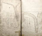 The original plat from 1829
 Drawing from the 1877 Warren County Atlas
 Baltimore's single remaining house
 Tombstones in Baltimore Cemetery
Municipalities and communities of Warren County, Indiana, United States | ||
|---|---|---|
| Towns | ||
| Townships | ||
| Unincorporated communities | ||
| Ghost towns | ||