Breadalbane (ship)
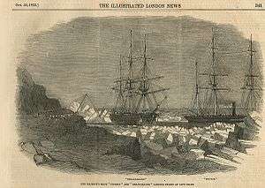 Breadalbane (left) and Phoenix off Beechey Island from the Illustrated London News | |
| History | |
|---|---|
| Name: | Breadalbane |
| Operator: | McNeil & Co |
| Builder: | Hedderwich & Rowan |
| Launched: | 1843 |
| Fate: | Crushed by ice on 21 August 1853 |
| General characteristics | |
| Type: | Wooden merchant ship |
| Tons burthen: | 428 bm |
| Length: | 38.1 metres (125 ft) |
| Beam: | 7.3 metres (24 ft) |
| Depth of hold: | 5.5 metres (18 ft) |
| Sail plan: | Barque |
Breadalbane was a British three-masted barque, a mid-19th century merchant ship that was crushed by ice and sank in the Arctic.
Notable as one of the northernmost shipwrecks known,[1][2][3] she is also considered one of the best-preserved wooden ships ever found in the sea due to slow deterioration in the cold Arctic water.[4] Historically, Breadalbane is considered to be a time capsule.[1]
On 21 August 1853, she became trapped by an ice floe and was crushed. She sank to the bottom of the Northwest Passage near Beechey Island in Lancaster Sound, approximately 500 miles north of the Arctic Circle.[5][6] Her entire crew of 21 abandoned ship in time, and were rescued by her companion, HMS Phoenix.
In August 1980, the wreck was discovered by a five-man team led by Dr. Joe MacInnis working from the Canadian Coast Guard icebreaker Sir John A. McDonald. Three years later it was designated a national historic site of Canada because the ship was used in the search for John Franklin's lost expedition.[7]
History
Breadalbane was built by Hedderwich & Rowan for a Scottish merchant consortium[8] in a shipyard on the Clyde River,[7] in Scotland in 1843.[4] The ship was originally used to transport wine, wool and grain to Europe, and spent her first ten years sailing between England and Calcutta carrying various goods.[7]
Design
Breadalbane was a 428-ton,[7] wooden square-rigged sailing ship. The design was similar to hundreds of other trans-oceanic ships used in early Victorian times. She was 38.1 metres (125 ft) long, with a beam of 7.3 metres (24 ft) and a hold depth of 5.5 metres (18 ft).[8]
Call to Arctic service
In the spring of 1853, the Royal Navy called the ship into service to transport coal and other supplies to the North Star, a depot ship.[8] She left the Thames River in 1853, accompanied by HMS Phoenix (the first propeller ship in the Arctic),[8] and arrived at a rallying point at Beechey Island later that year.[7] Her new mission would be to carry supplies to Sir Edward Belcher's high Arctic search expedition in the Resolute Bay area (now part of Nunavut). Since 1852, Belcher's expedition had been searching for the Franklin Expedition. The ship and crew had gone missing while searching for a passage through the Arctic seas. Belcher's expedition both the largest, and the last sent by the Royal Navy.
Trapped in the ice
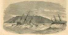
On 21 August 1853, Breadalbane was anchored to an ice floe[8] half a mile south of Beechey Island in Lancaster Sound, approximately 500 miles north of the Arctic Circle.[2] It had become surrounded by slow-moving ice.[7] Shortly after midnight, a slab of ice penetrated the starboard bow.
| “ | About ten minutes past four a.m., the ice passing the ship awoke me, and the door of my cabin from the pressure opened: I immediately hurriedly put on my clothes, and on getting up found some hands on the ice, endeavoring to save the boats, but they were instantly crushed to pieces; they little thought, when using their efforts to save the boats, that the Breadalbane was in so perilous a situation. I went forward to hail the Phoenix, for men to save the boats, and whilst doing so, the ropes by which we were secured parted, and a heavy nip took the ship making every timber in her creak, and the ship tremble all over. I looked in the main hold, and saw the beams given away; I hailed those on the ice and told them of our critical situation, they not for one moment suspecting it. I then rushed to my cabin, hauled out my portmanteau on the deck, and roared like a bull to those in their beds to jump out and save their lives. The startling effects on them might be more easily imagined than described. On reaching the deck those on the ice called out to me to jump over the side, that the ship was going over | ” |
| — William H Fawckner[9] | ||
The crew quickly salvaged as many supplies and personal items as possible.[7] The 21-man crew then abandoned the ship. Within fifteen minutes, the vessel sank to the floor of Barrow Strait[7] in an approximate position of 74°41′N 91°50′W / 74.683°N 91.833°WCoordinates: 74°41′N 91°50′W / 74.683°N 91.833°W. The crew was rescued by HMS Phoenix.[2]
Discovery and exploration
The wreck of Breadalbane was first discovered in August 1980 by a five-man team led by Joseph B. MacInnis. The Canadian government and National Geographic supported the search. Using side-scan sonar towed by the Canadian Coast Guard icebreaker CCGS John A. McDonald, the ship was found in 100 metres of water 1.5 kilometres south of Beechey Island in the Northwest Passage. She was lying intact on the seafloor with two of her three masts still standing and her bow pointing east. Gary Kozak (Klien Associates) operated the side-scan sonar. Emory Kristoff (National Geographic) used a drop-camera to take the first video and 35mm. photographs. The images showed parts of the foredeck, foremast, starboard railing, main deck, and a capstan.
Two previous attempts in 1978 and 1979, also led by Dr. MacInnis, failed to find any trace of the ship.
In September 1981, Dr. MacInnis, working on the Canadian Coast Guard icebreaker CCGS Pierre Radisson, led a six-man team that used a remotely operated vehicle to record video and 35mm. color photographs. Chris Nicholson (Benthos) managed the remotely operated vehicle in tandem with Emory Kristoff (National Geographic). More than one thousand images revealed a debris field with the fallen mast, the ship's copper-sheathed lower hull, and a flat-roofed deckhouse. A small cabinet on the aft end of the deckhouse held a compass and signal light. Below the cabinet was the wooden steering wheel. The ship was wrapped in soft, pink coral. This expedition was documented by the CBC's Fifth Estate in a segment hosted by Bob McKeown.
In 1983, after waiting two years for the polar ice pack to stabilize over the site, Dr. MacInnis led a 24-man team that built an eight-structure camp, cut through a meter of ice, and made four manned dives and six remotely operated vehicle dives. The expedition lasted 20 days. The manned dives were made in the one-atmosphere WASP suit. Phil Nuytten (Can-Dive Services) led the dive team, Emory Kristoff (National Geographic) the underwater camera team, Chris Nicholson the ROV team, Pete Jess (Dome Petroleum) the logistics team, and Steve Blasco (Bedford Institute of Oceanography) the science team. On the last dive, the ship's wheel was recovered by Doug Osborne in the WASP suit and turned over to Parks Canada for preservation and display. HRH Prince Charles visited the site on one occasion with Dr. McGinnis.
The 1983 expedition was documented in a National Film Board production The Land That Devours Ships (1984), a National Geographic cover story (Exploring a 140-Year-Old Ship Under Arctic Ice, April 1983) and a book written by Dr. MacInnis. CBC Enterprises published The Land That Devours Ships in 1985. The 1980, 1981, and 1983 video images are archived at the Bedford Institute of Oceanography and Ryerson University. The 35mm. photographs are archived at National Geographic Society in Washington.
In April 2014, an expedition returned to film Breadalbane for the first time in 31 years. The seven-member team used ROVs to take a series of high-definition pictures of the wreck, which is apparently still well-preserved.[10]
References
- 1 2 MacInnis, Joseph B. "Breadalbane". The Canadian Encyclopedia. Retrieved 2011-12-31.
- 1 2 3 "The Farthest North Known Shipwreck: the H.M.S. Breadalbane | Arctos Canadensis". Northernwaterways.com. 2009-03-08. Retrieved 2011-08-23.
- ↑ "Archives & Special Collections". Ryerson.ca. Retrieved 2011-08-23.
- 1 2 Payne, Doug (15 January 1981). "Technology lights up an Arctic shipwreck". New Scientist. Reed Business Information. 89 (1236): 136–139. ISSN 0262-4079. Retrieved 2011-12-23.
- ↑ Anchorage Daily News – 15 September 1981
- ↑ Andrew H. Malcolm (1982-01-03). "A Find That Would Shiver Anyone's Timbers". Arctic Regions: NYTimes.com. Retrieved 2011-08-23.
- 1 2 3 4 5 6 7 8 "HistoricPlaces.ca". HistoricPlaces.ca. 1983-06-13. Retrieved 2011-08-23.
- 1 2 3 4 5 Paine, Lincoln P. (2000). Ships of Discovery and Exploration. Boston, New York: Houghton Mifflin. pp. 26–27. ISBN 0-395-98415-7. Retrieved 2011-12-31.
- ↑ Illustrated London News, 22 October 1853
- ↑ Eerie new underwater footage shows historic Arctic shipwreck — the northernmost known — in fresh detail by Joe O'Connor, National Post, 25 April 2014.
Further reading
- MacInnis, Joseph B. (1982). The Breadalbane adventure. Optimum Pub. International. ISBN 978-0-88890-159-0. Retrieved 3 September 2011.
- MacInnis, Joseph B. (1985). The land that devours ships: the search for the Breadalbane. CBC Enterprises. ISBN 978-0-88794-196-2. Retrieved 3 September 2011.
- MacInnis, Joseph B. (July 1983). "Exploring a 140-year-old Ship Under Arctic Ice". National Geographic. Vol. 164 no. 1. pp. 104A–104D. ISSN 0027-9358. OCLC 643483454.
External links
| Wikimedia Commons has media related to Breadalbane (ship, 1843). |
| Shipwrecks |
|
|---|---|
| Other incidents |
|
1852 | |