Brantford Airport
| Brantford Airport Brantford Municipal Airport | |||||||||||||||||||
|---|---|---|---|---|---|---|---|---|---|---|---|---|---|---|---|---|---|---|---|
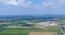 CYFD From the West | |||||||||||||||||||
| Summary | |||||||||||||||||||
| Airport type | Public | ||||||||||||||||||
| Owner/Operator | City of Brantford | ||||||||||||||||||
| Serves | Brantford, Ontario | ||||||||||||||||||
| Location | Brantford, Ontario | ||||||||||||||||||
| Time zone | EST (UTC−05:00) | ||||||||||||||||||
| • Summer (DST) | EDT (UTC−04:00) | ||||||||||||||||||
| Elevation AMSL | 815 ft / 248 m | ||||||||||||||||||
| Coordinates | 43°07′57″N 080°20′29″W / 43.13250°N 80.34139°WCoordinates: 43°07′57″N 080°20′29″W / 43.13250°N 80.34139°W | ||||||||||||||||||
| Website | www.BrantfordAirport.ca | ||||||||||||||||||
| Map | |||||||||||||||||||
 CYFD Location in Ontario | |||||||||||||||||||
| Runways | |||||||||||||||||||
| |||||||||||||||||||
|
Source: Canada Flight Supplement[1] | |||||||||||||||||||
Brantford Airport (ICAO: CYFD), also known as Brantford Municipal Airport, is a registered aerodrome located 4 nautical miles (7.4 km; 4.6 mi) west southwest of the City of Brantford, in the county of Brant, Ontario, Canada. There is a single fixed-base operator at the airport. The airport hosts a widely attended air show every year at the end of August, featuring the Royal Canadian Air Force aerobatic team the Snowbirds and airplanes from the Canadian Warplane Heritage Museum. The airport is home to many of the area's general aviation aircraft. Aviation spare parts retailer Aircraft Spruce established its sole Canadian location here in 2008, with expansion plans announced in 2013. The airport is often used for film shoots; scenes from Welcome to Mooseport, Where The Truth Lies and multiple Mayday episodes have been filmed there.
Although the airport has never had scheduled air service, weekly charters fly students of the W. Ross Macdonald School home to Sudbury, Timmins, Trenton, Ottawa and Sault Ste. Marie.
The airport is classified as an airport of entry by Nav Canada and is staffed by the Canada Border Services Agency (CBSA). The CBSA officers at this airport currently can handle general aviation aircraft only, with no more than 15 passengers.[1]
History
A public aerodrome was established at Brantford in 1929 (located at Fairview and King George streets). The airport opened at its present location on 11 November 1940 as No. 5 Service Flying Training School, a Royal Canadian Air Force British Commonwealth Air Training Plan airfield.[2] It wasn't until 27 April 1970 that aerodrome lands and management duty were transferred from the federal government to the municipal level. The current terminal building was built in 1966. The City of Brantford once looked at the possibility of closing the airport, but this move was widely opposed by local citizens, tenants and users. In May 2007, Brantford City Council held a public forum to canvass views on the airport as an essential/necessary Service for the city. Many presentations made clear points that growing cities require airports as part of their fundamental infrastructure, to attract and retain corporate investment. In January 2008, Brantford City Council voted unanimously to support the inclusion of $1.9 million in planned airport infrastructure upgrades in the city's Capital Plan for Fiscal 2008. This allowed for repaving the main runway, plus a second runway that was last paved in the 1940s. In 2004, 2009 and 2011, new rows of hangars were built, with plans for more in the future. In August 2014, an experimental aircraft crashed near the airport.[3] Early the next month, a small aircraft crashed while on approach to the airport, killing one pilot.[4] On April 27, 2016, a Cessna 182 flipped over on the runway, injuring one pilot.[5]
 Main public area
 Terminal Building
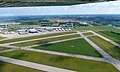 Pilots Beware!
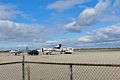 EMB-500 refuelling
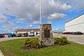
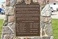 Plaque for No. 5 SFTS
References
- 1 2 Canada Flight Supplement. Effective 0901Z 19 July 2018 to 0901Z 13 September 2018.
- ↑ Hatch, F. J. (1983). Aerodrome of Democracy: Canada and the British Commonwealth Air Training Plan 1939–1945. Ottawa: Canadian Department of National Defence. ISBN 0-660-11443-7.
- ↑ http://www.cbc.ca/news/canada/hamilton/news/experimental-aircraft-crashes-near-brantford-airport-1.2750386
- ↑ http://www.brantfordexpositor.ca/2014/09/03/plane-crashes-near-brantford-airport-killing-one
- ↑ http://www.brantfordexpositor.ca/2016/04/27/pilot-injured-after-plane-flips-over-on-brantford-airport-runway
External links
- Brantford Municipal Airport (official web site)
- Brantford Flight Centre
- COPA Flight 148 Brantford - Local Canadian Owners and Pilots Association Group
- Brantford Airport Closure Questioned - Press release from Brant Aero
- Brant Aero - Avionics and maintenance shop based at the Airport
- Brantford Municipal Airport on COPA's Places to Fly airport directory
- Accident history for YFD: Brantford Airport at Aviation Safety Network
| By name | |
|---|---|
| By location indicator | |
| By province/territory | |
| By area | |
| National Airports System | |
| Related | |
| |