Braintree District
| Braintree District | |
|---|---|
| Non-metropolitan district | |
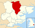 Braintree shown within Essex | |
| Sovereign state | United Kingdom |
| Constituent country | England |
| Region | East of England |
| Non-metropolitan county | Essex |
| Status | Non-metropolitan district |
| Admin HQ | Braintree |
| Incorporated | 1 April 1974 |
| Government | |
| • Type | Non-metropolitan district council |
| • Body | Braintree District Council |
| • Leadership | Leader & Cabinet (Conservative) |
| • MPs |
James Cleverly Priti Patel |
| Area | |
| • Total | 236.18 sq mi (611.71 km2) |
| Area rank | 68th (of 326) |
| Population (mid-2017 est.) | |
| • Total | 151,700 |
| • Rank | 128th (of 326) |
| • Density | 640/sq mi (250/km2) |
| • Ethnicity |
95.% White 1.1% Mixed 1.3% S.Asian 1.0% Black |
| Time zone | UTC0 (GMT) |
| • Summer (DST) | UTC+1 (BST) |
| ONS code |
22UC (ONS) E07000067 (GSS) |
| OS grid reference | TL7522 |
| Website |
www |
Braintree is a local government district in the English county of Essex, with a population (2011 census) of 147,084. Its main town is Braintree.
The main centres of population are Braintree, Witham and Halstead.
The district was formed on 1 April 1974 by the merger of the urban districts of Braintree and Bocking, Halstead, and Witham and (for list of Parishes) Braintree Rural District and Halstead Rural District.
Council
The council is controlled by the Conservatives who hold 41 of the 45 seats.[1]
Wards
There are 26 wards[2]:
- Bocking Blackwater
- Bocking North
- Bocking South
- Braintree Central and Beckers Green
- Braintree South
- Braintree West
- Bumpstead
- Coggeshall
- Gosfield & Greenstead Green
- Great Notley & Black Notley
- Halstead St Andrews
- Halstead Trinity
- Hatfield Peverel and Terling
- Hedingham
- Kelvedon and Feering
- Rayne
- Silver End and Cressing
- Stour Valley North (includes Ashen and Foxearth)
- Stour Valley South (includes Bulmer and Alphamstone)
- The Colnes
- Three Fields
- Witham Central
- Witham North
- Witham South
- Witham West
- Yeldham
References
- ↑ "Braintree | LocalCouncils.co.uk". localcouncils.co.uk. Retrieved 2018-03-30.
- ↑ Braintree District Council http://braintree.cmis.uk.com/braintree/Councillors/tabid/63/ScreenMode/Ward/Default.aspx
External links
| Wikimedia Commons has media related to Braintree. |
- Enjoy Braintree District; places to stay, arts, museum, culture events listing by the Braintree Council
- Braintree District Council
- Enjoy Braintree District
Districts of the East of England | ||
|---|---|---|
| Bedfordshire |  | |
| Cambridgeshire | ||
| Essex | ||
| Hertfordshire | ||
| Norfolk | ||
| Suffolk |
| |
Coordinates: 51°52′55″N 0°33′09″E / 51.8819°N 0.5525°E
This article is issued from
Wikipedia.
The text is licensed under Creative Commons - Attribution - Sharealike.
Additional terms may apply for the media files.