Borger-Odoorn
| Borger-Odoorn | |||
|---|---|---|---|
| Municipality | |||
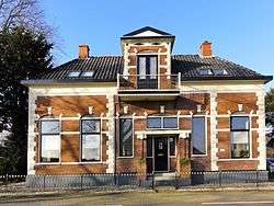 Monumental home in Tweede Exloërmond | |||
| |||
.svg.png) Location in Drenthe | |||
| Coordinates: 52°53′N 6°52′E / 52.883°N 6.867°ECoordinates: 52°53′N 6°52′E / 52.883°N 6.867°E | |||
| Country | Netherlands | ||
| Province | Drenthe | ||
| Established | 1 January 1998[1] | ||
| Government[2] | |||
| • Body | Municipal council | ||
| • Mayor | Jan Seton (CDA) | ||
| Area[3] | |||
| • Total | 277.89 km2 (107.29 sq mi) | ||
| • Land | 275.27 km2 (106.28 sq mi) | ||
| • Water | 2.62 km2 (1.01 sq mi) | ||
| Elevation[4] | 23 m (75 ft) | ||
| Population (August 2017)[5] | |||
| • Total | 25,351 | ||
| • Density | 92/km2 (240/sq mi) | ||
| Time zone | UTC+1 (CET) | ||
| • Summer (DST) | UTC+2 (CEST) | ||
| Postcode | Parts of 7800 and 9500 range | ||
| Area code | 0591, 0599 | ||
| Website |
www | ||


Borger-Odoorn (![]()
The municipality has as partner city Hořice from the Czech Republic.
Population centers
Borger, Bronneger, Bronnegerveen, Buinen, Buinerveen, Drouwen, Drouwenermond, Drouwenerveen, Eerste Exloërmond, Ees, Eesergroen, Eeserveen, Ellertshaar, Exloërveen, Exloo, Klijndijk, Nieuw-Buinen, Odoorn, Odoornerveen, Tweede Exloërmond, Tweede Valthermond, Valthe, Valthermond, Westdorp, Zandberg.
Topography

Dutch Topographic map of the municipality of Borger-Odoorn, June 2015.
References
- ↑ "Gemeentelijke indeling op 1 januari 1998" [Municipal divisions on 1 January 1998]. cbs.nl (in Dutch). CBS. Retrieved 5 October 2013.
- ↑ "Burgemeester en wethouders" [Mayor and aldermen] (in Dutch). Gemeente Borger-Odoorn. Retrieved 5 October 2013.
- ↑ "Kerncijfers wijken en buurten" [Key figures for neighbourhoods]. CBS Statline (in Dutch). CBS. 2 July 2013. Retrieved 12 March 2014.
- ↑ "Postcodetool for 7875AD". Actueel Hoogtebestand Nederland (in Dutch). Het Waterschapshuis. Retrieved 5 October 2013.
- ↑ "Bevolkingsontwikkeling; regio per maand" [Population growth; regions per month]. CBS Statline (in Dutch). CBS. 27 October 2017. Retrieved 27 October 2017.
External links
Places adjacent to Borger-Odoorn | ||||||||||
|---|---|---|---|---|---|---|---|---|---|---|
| ||||||||||
Municipalities of Drenthe | ||
|---|---|---|
 | ||
| ||
This article is issued from
Wikipedia.
The text is licensed under Creative Commons - Attribution - Sharealike.
Additional terms may apply for the media files.