Borders of Israel
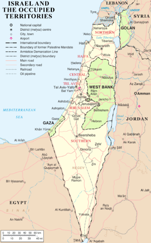
The current borders of the State of Israel are the result both of war and of diplomatic agreements among Israel, her neighbors, and colonial powers. Uniquely, only two of Israel's five potential land borders are internationally recognized while the other three are disputed.[1] Israel's borders with Egypt and Jordan have now been formally recognized and confirmed as part of the peace treaties with those countries. The borders with Syria (Golan Heights), Lebanon (Shebaa farms) and the Palestinian territories (declared as the State of Palestine) are still in dispute.[2]
According to the Green Line of the 1949 Armistice Agreements, Israel borders Lebanon in the north, the Golan Heights and Syria in the northeast, the West Bank and Jordan in the east, the Gaza Strip and Egypt in the southwest. The border with Egypt is the international border demarcated in 1906 between the United Kingdom and the Ottoman Empire, confirmed in the 1979 Egypt–Israel Peace Treaty, and the border with Jordan is based on the border defined in the 1922 Trans-Jordan memorandum, confirmed in the 1994 Israel–Jordan peace treaty.
Early background
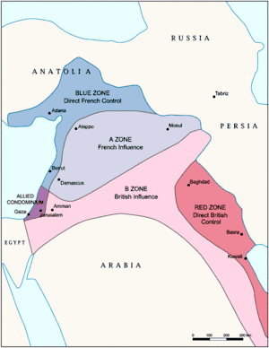
The Sykes–Picot Agreement of 1916 secretly divided the Ottoman Empire lands of Middle East between British and French spheres of influence. They agreed that "Palestine" was to be designated as an "international enclave".[3]
This agreement was revised by Britain and France in 1919. It was agreed that Palestine and the Vilayet of Mosul in modern-day Iraq would be part of the British sphere in exchange for British support of French influence in Syria and Lebanon.[4] According to historian Ilan Pappe,
"The borders of mandatory Palestine, first drawn up in the Sykes-Picot Agreement, were given their definitive shape during lengthy and tedious negotiations by British and French officials between 1919 and 1922 ... In October 1919 the British envisaged the area that is today southern Lebanon and most of southern Syria as being part of British mandatory Palestine ... In the East, matters were more complicated...[Transjordan] was part of the Ottoman province of Damascus which in the Sykes-Picot agreement had been allocated to the French."[5]
At the San Remo Conference (19–26 April 1920) the Allied Supreme Council granted the mandates for Palestine and Mesopotamia to Britain without precisely defining the boundaries of the mandated territories.[6][7]
Border with Jordan
British Mandate
In March 1921, the Colonial Secretary Winston Churchill visited Jerusalem and following a discussion with Emir Abdullah, it was agreed that Transjordan was to be added to the proposed Palestine Mandate, but that the Jewish National Home objective for the proposed Palestine Mandate would not apply to the territory.
In July 1922, the League of Nations approved the Palestine Mandate, which came into effect in 1923 after a dispute between France and Italy over the Syria Mandate was settled. The Mandate stated that Britain could ‘postpone or withhold’ application of the provisions dealing with the 'Jewish National Home' in the territory east of the Jordan River, then called Transjordan. In September 1922, following Abdullah's probation period,[11] the British government presented a memorandum to the League of Nations defining the border of Transjordan and confirming its exclusion from all the provisions dealing with Jewish settlement.
Britain administered the part west of the Jordan as Palestine, and the part east of the Jordan as Transjordan, with the border being the Jordan River. Palestine comprised 23% of the Mandate territory and Transjordan comprised 77%. Technically they were one mandate but most official documents referred to them as two separate mandates. Transjordan remained under British control until 1946, when it gained independence.[12]
End of British Mandate
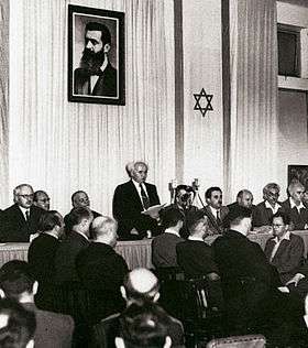
On 29 November 1947, the General Assembly of the United Nations adopted a resolution recommending the adoption and implementation of a plan to partition Palestine into "Independent Arab and Jewish States" and a "Special International Regime for the City of Jerusalem" administered by the United Nations (Resolution 181 (II)).[13] Britain declared that the Mandate was to end on 15 May 1948. On 14 May 1948, David Ben-Gurion, in a ceremony in Tel Aviv, declared "the establishment of a Jewish state in Eretz-Israel, to be known as the State of Israel."[14]
Eliahu Epstein, Agent, Provisional Government of Israel said in a letter to President Truman seeking recognition from the U.S government, sent immediately after the Declaration of 14 May 1948, "that the state of Israel has been proclaimed as an independent republic within frontiers approved by the General Assembly of the United Nations in its Resolution of November 29, 1947."[15]
Subsequent events
In 1988, Palestine declared its independence without specifying its borders. Jordan extended recognition to Palestine and ceded its claim to the West Bank to the Palestinian Liberation Organisation, which had been previously designated by the Arab League as the "sole legitimate representative of the Palestinian people".[16]
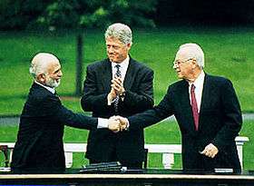
The Israel–Jordan peace treaty was signed on October 26, 1994. The treaty resolved territorial and border issues that were ongoing since the 1948 war. The treaty specified and fully recognized the international border between Israel and Jordan. Upon its signing, the Jordan and Yarmouk Rivers, the Dead Sea, the Emek Ha'arva/Wadi Araba and the Gulf of Aqaba were officially designated as the borders between Israel and Jordan and between Jordan and the territory occupied by Israel in 1967.[17] For the latter, the agreement requires that the demarcation use a different presentation, and that it carry the following disclaimer:
"This line is the administrative boundary between Jordan and the territory which came under Israeli military government control in 1967. Any treatment of this line shall be without prejudice to the status of the territory."[18]
In 2011, Palestine submitted an application for membership to the United Nations, using the borders for military administration that existed before 1967.[19] As Israel does not recognize the State of Palestine, Jordan's borders with Israel remain unclear.
Border with Syria and Lebanon
French Mandate: Paulet–Newcombe Agreement
The Paulet–Newcombe Agreement, a series of agreements between 1920–23, contained the principles for the boundary between the Mandates of Palestine and Mesopotamia, attributed to Great Britain, and the Mandate of Syria and the Lebanon, attributed to France.
A 1920 agreement defined the boundary between the forthcoming British and French mandates in broad terms,[20] and placed the bulk of the Golan Heights in the French sphere. The agreement also established a joint commission to settle the border and mark it on the ground.[20] The commission submitted its final report on 3 February 1922, and it was approved with some caveats by the British and French governments on 7 March 1923,[21] several months before Britain and France assumed their Mandatory responsibilities on 29 September 1923.[22] In accordance with the same process, a nearby parcel of land that included the ancient site of Dan was transferred from Syria to Palestine early in 1924. In this way the Golan Heights became part of the French Mandate of Syria. When the French Mandate of Syria ended in 1944, the Golan Heights remained part of the newly independent state of Syria.
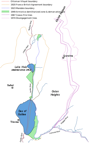
In 1923, an agreement between the United Kingdom and France, known as the Paulet–Newcombe Agreement, established the border between the soon-to-be formalised British Mandate of Palestine and the French Mandate of Syria.[21] The British handed over the southern Golan Heights to the French in return for the northern Jordan Valley. The border was drawn so that both sides of the Jordan River and the whole of the Sea of Galilee, including a 10-metre-wide strip along the northeastern shore, were part of Palestine.[23][24]
Syria: subsequent changes
The 1947 UN Partition Plan allocated this territory to the Jewish state. Following the 1948 Arab–Israeli War, Syria seized some land that had been allocated to the Jewish state and under the 1949 Armistice Agreements with Israel retained 66 square kilometers of that territory in the Jordan Valley that lay west of the 1923 Palestinian Mandate border (marked green in the map on right).[25] These territories were designated demilitarized zones (DMZs) and remained under Syrian control (marked as DMZs on second map). It was emphasised that the armistice line was "not to be interpreted as having any relation whatsoever to ultimate territorial arrangements." (Article V)
During the Six-Day War (1967), Israel captured the territory as well as the rest of the Golan Heights, and subsequently repelled a Syrian attempt to recapture it during the Yom Kippur War (1973). Israel annexed the Golan Heights in 1981 with the Golan Heights Law.[26] Israel began building settlements throughout the Golan Heights, and offered the Druze and Circassian residents citizenship, which most turned down. Today, Israel regards the Golan Heights as its sovereign territory, and a strategic necessity. The Purple Line marks the boundary between Israel and Syria. Israel's unilateral annexation has not been internationally recognized, and United Nations Security Council Resolution 242 refers to the area as Israeli-occupied.
During the 1990s, there were constant negotiations between Israel and Syria regarding a mediation of conflicts and an Israeli withdrawal from the Golan Heights but a peace treaty did not come to fruition.[27] The main stumbling block seems to involve the 66 square kilometers of territory that Syria retained under the 1949 armistice agreement.[28] Arab countries support Syria's position in the formula which calls on Israel "to return to the 1967 borders". (See 2002 Arab Peace Initiative)
Lebanon conflict
On March 14, 1978, Israel launched Operation Litani, occupying the area south of the Litani River, excepting Tyre (see map). In response to the invasion, the UN Security Council passed Council Resolution 425 and Resolution 426 calling for the withdrawal of Israeli forces from Lebanon. Israeli forces withdrew later in 1978, but turned over their positions inside Lebanon to their ally, the South Lebanon Army (SLA).
The United Nations in June 2000 was called upon to decide the Lebanese border to determine whether Israel had fully withdrawn from Lebanon in compliance with UN Security Council Resolution 425. This line came to be called the Blue Line. At the same time, the United Nations did not have to consider the legality of the boundary between Lebanon and the Israeli-controlled Golan Heights, as that was not required for the purpose of Council Resolution 425. Accordingly, the Armistice Demarcation Line between Lebanon and the Israeli-controlled Golan Heights is expressly not to be called the Blue Line.
The Blue Line, which the UN had to determine was the line of deployment of the IDF before March 14, 1978, when Israel invaded Lebanon. In effect that line was recognised by both Lebanon and by Israel as the international border, and not just as the Armistice Demarcation Line of 1949 (what is commonly called the Green Line) following the 1948 Arab–Israeli War.
On April 17, 2000, Israel announced that it would withdraw its forces from Lebanon. The Lebanese government refused to take part in marking the border. The UN thus conducted its own survey based on the line for the purpose of Council Resolution 425, which called for "strict respect for the territorial integrity, sovereignty and political independence of Lebanon within its internationally recognized boundaries".
From May 24 to June 7, 2000, the UN Special Envoy heard views in Israel, Lebanon and Syria. The United Nations cartographer and his team, assisted by UNIFIL, worked on the ground to identify a line to be adopted for the practical purposes of confirming the Israeli withdrawal. While it was agreed that this would not be a formal border demarcation, the aim was to identify a line on the ground closely conforming to the internationally recognized boundaries of Lebanon, based on the best available cartographic and other documentary evidence. On May 25, 2000, Israel notified the Secretary-General that it had redeployed its forces in compliance with Council Resolution 425, that is to the Internationally recognized Lebanese border. On June 7, the completed map showing the withdrawal line was formally transmitted by the force commander of UNIFIL to his Lebanese and Israeli counterparts. Notwithstanding their reservations about the line, the governments of Israel and Lebanon confirmed that identifying this line was solely the responsibility of the United Nations and that they would respect the line as identified.
On June 8, UNIFIL teams commenced the work of verifying the Israeli withdrawal behind the line.
The Blue Line
The Blue Line identified by the United Nations in 2000 as the border of Lebanon, from the Mediterranean Sea to the Hasbani River, closely approximates the Green Line set under the 1949 armistice agreement between Lebanon and Israel.[29] The area east of the Hasbani River, is considered part of Syria and included in the Golan Heights.
The armistice agreement between Lebanon and Israel was signed on March 23, 1949. The main points were:
- The terms of the agreement were dictated exclusively by military considerations
- The armistice line (i.e. "Green Line") was the international border, which corresponds to the 1923 Mandate border between the Lebanon and Palestine (see: Treaty of Sèvres).
- Unlike the other Green Line agreements, it contains no clause disclaiming this line as an international border, and was thereafter treated as it had been previously, as the de jure international border of Lebanon.
- Israel withdrew its forces from 13 villages in Lebanese territory, which were occupied during the war.
In 1923, 38 boundary markers were placed along the 49-mile (78 km) boundary and a detailed text description was published. The 2000 Blue Line differs in about a half dozen short stretches from the 1949 line, though never by more than 475 meters.
Between 1950 and 1967, Israeli and Lebanese surveyors managed to complete 25 non-contiguous kilometers and mark (but not sign) another quarter of the international border.
On June 16, the Secretary-General reported to the Security Council that Israel had withdrawn its forces from Lebanon in accordance with Council Resolution 425 and met the requirements defined in his report of May 22, 2000.[30] The withdrawal line has been termed the Blue Line in all official UN communications since.
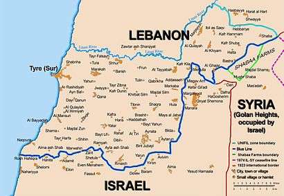
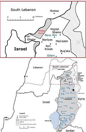
Conflict over the Shebaa Farms
The Shebaa Farms conflict stems from Israel's occupation and annexation of the Golan Heights, with respect to that territory's border with Lebanon. Both Lebanon and Syria were within the French Mandate Territory between 1920 and the end of the French Mandate in 1946. The dispute over the sovereignty over the Shebaa Farms resulted in part from the failure of French Mandate administrations, and subsequently from the failure of the Lebanon and Syria to properly demarcate the border between them.
Documents from the 1920s and 1930s indicate that some local inhabitants regarded themselves as part of Lebanon, for example paying taxes to the Lebanese government. But French officials at times expressed confusion as to the actual location of the border.[31] One French official in 1939 expressed the belief that the uncertainty was sure to cause trouble in the future.
The region continued to be represented in the 1930s and 1940s as Syrian territory, under the French Mandate. Detailed maps showing the border were produced by the French in 1933, and again in 1945.[32] They clearly showed the region to be in Syria.
After the French Mandate ended in 1946, the land was administered by Syria, and represented as such in all maps of the time.[33] The maps of the 1949 armistice agreement between Syria and Israel also designated the area as Syrian.
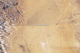
Border disputes arose at times, however. Shebaa Farms was not unique; several other border villages had similar discrepancies of borders versus land ownership. Syria and Lebanon formed a joint Syrian–Lebanese border committee in the late 1950s to determine a proper border between the two nations. In 1964, concluding its work, the committee suggested to the two governments that the area be deemed the property of Lebanon, and recommended that the international border be reestablished consistent with its suggestion. However, neither Syria nor Lebanon adopted the committee's suggestion, and neither country took any action along the suggested lines. Thus, maps of the area continued to reflect the Farms as being in Syria.[33] Even maps of both the Syrian and Lebanese armies continued to demarcate the region within Syrian territory (see map).[33]
A number of local residents regarded themselves as Lebanese, however. The Lebanese government showed little interest in their views. The Syrian government administered the region, and on the eve of the 1967 war, the region was under effective Syrian control.
In 1967, most Shebaa Farms landowners and (Lebanese) farmers lived outside the Syrian-controlled region, across the Lebanon-Syrian border, in the Lebanese village of Shebaa. During the Six Day War in 1967, Israel captured the Golan Heights from Syria, including the Shebaa Farms area. As a consequence, the Lebanese landowners were no longer able to farm it.[34]
Border with Egypt
The international border between the Ottoman Empire and British controlled Egypt was drawn in the Ottoman–British agreement of 1 October 1906.[35]
According to the personal documents of the British colonel Wilfed A. Jennings Bramley, who influenced the negotiations, the border mainly served British military interests—it furthered the Ottomans as much as possible from the Suez Canal, and gave Britain complete control over both Red Sea gulfs—Suez and Aqaba, including the Straits of Tiran. At the time, the Aqaba branch of the Hejaz railway had not been built, and the Ottomans therefore had no simple access to the Red Sea. The British were also interested in making the border as short and patrollable as possible, and did not take into account the needs of the local residents in the negotiations.[36]
The 1949 armistice agreement between Israel and Egypt was ratified on February 24, 1949. The armistice line between these countries followed the international border except along the Gaza Strip, which remained under Egyptian occupation.[37]
The Egypt–Israel Peace Treaty, signed on March 26, 1979, created an officially recognized international border along the 1906 line, with Egypt renouncing all claims to the Gaza Strip. A dispute arose over the marking of the border line at its southernmost point, in Taba. Taba was on the Egyptian side of the armistice line of 1949, but Israel claimed that Taba had been on the Ottoman side of a border agreed between the Ottomans and British Egypt in 1906, and that there had previously been an error in marking the line. The issue was submitted to an international commission composed of one Israeli, one Egyptian, and three outsiders. In 1988, the commission ruled in Egypt's favor, and Israel withdrew from Taba later that year.
Borders with Palestine
On 29 November 1947, the UN General Assembly adopted a resolution recommending to the United Kingdom, as the mandatory Power for Palestine, and to all other Members of the United Nations the adoption and implementation, with regard to the future government of Palestine, of the Plan of Partition with Economic Union as Resolution 181 (II).[38] The Plan contained a proposal to terminate the British Mandate for Palestine and partition Palestine into Independent Arab and Jewish States and the Special International Regime for the City of Jerusalem. The Jewish community of Mandate Palestine accepted the plan, despite its misgivings. With a few exceptions, the Arab leaders and governments rejected the plan of partition in the resolution and indicated that they would reject any other plan of partition. On 14 May 1948, the day before the expiration of the Mandate for Palestine, David Ben-Gurion, on behalf of the Jewish community, declared the establishment of a Jewish state in Eretz-Israel, to be known as the State of Israel.[39]

On the next day, the Arab armies marched their forces into what had been the British Mandate for Palestine. This intervention/invasion from all sides turned the 1947–1948 Civil War in Mandatory Palestine into the 1948 Arab–Israeli War. The tide of battle soon turned against the Arabs, and Israel then launched a series of military offensives, greatly expanding its territorial holdings. On September 22, 1948, during a truce in the war, the Provisional State Council of Israel passed a law annexing all land that Israel had captured in that war, and declaring that from then on, any part of Palestine taken by the Israeli army would automatically be annexed to Israel.[40] The end of the war saw the Lausanne Conference of 1949. Following internationally supervised Arab-Israeli negotiations, a boundary based on the cease-fire lines of the war with minor territorial adjustments, commonly referred to as the Green Line, was agreed upon in the 1949 Armistice Agreements. The Green Line was expressly declared in the Armistice Agreements as a temporary demarcation line, rather than a permanent border, and the Armistice Agreements relegated the issue of permanent borders to future negotiations. The area to the west of the Jordan River came to be called the West Bank, and was annexed by Jordan in 1950;[41] and the Gaza Strip was controlled by Egypt. During the Six-Day War of 1967, Israel captured the West Bank from Jordan, Gaza Strip and Sinai peninsula from Egypt, and Golan Heights from Syria, and placed these territories under military occupation.
Israel and the Palestinian territories now lay entirely within the boundaries of former British Mandate Palestine. By the Egypt–Israel Peace Treaty of 1979, Egypt renounced all claims to the Gaza Strip. In 1988, Jordan renounced all claims to the West Bank;[42] this was made official in the Israel–Jordan Treaty of Peace of 1994. The Green Line is Israel's contested boundary with the Palestinian territories.
The boundaries of a future Palestinian State, vis-a-vis Israel, are subject to ongoing negotiations in the Israel–Palestinian peace process. Israel's West Bank Wall, which encompasses almost all Israeli settlements, including all three major cities, and only a minor Palestinian population, was declared by Prime Minister Ehud Olmert as running roughly along the future borders of Israel. Israeli Foreign Minister Avigdor Lieberman proposed that the Arab-Israeli border region known as the Triangle be removed from Israeli sovereignty and transferred to the Palestinian Authority, in exchange for the border settlement blocs. The Palestinian Authority claims all of these territories (including East Jerusalem) for a future Palestinian State, and its position is supported by the Arab League in the 2002 Arab Peace Initiative which calls for the return by Israel to "the 1967 borders". While Israel has expressed desire to annex the border settlement blocs and keep East Jerusalem, its border with Gaza has largely been solidified, especially following Israel's withdrawal in 2005. Israel has not made claims to any portion Gazan territory and offered the entire area to Palestinians as part of the 2000 Camp David Summit.
At the same time, Israel has continued to claim a nominal strip on the border between the West Bank and Jordan, and between Gaza and Egypt as its border with those countries. This is viewed as a legalistic device to enable Israel to control the entry of people and materials into the Palestinian territories.
Status of Jerusalem
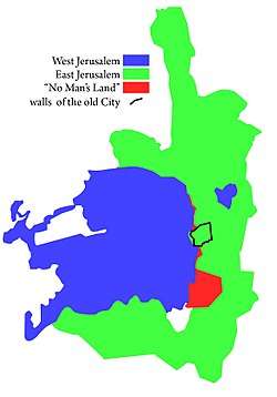
The status and boundary of Jerusalem continue to be in dispute.
Israel took control of West Jerusalem during the 1948 Arab–Israeli War, while Jordan took control of East Jerusalem (including the walled Old City in which most holy places are located). During the Six-Day War of 1967, Israel gained control of East Jerusalem, and shortly after extended Jerusalem’s municipality city limits and applied its laws, jurisdiction, and administration to East Jerusalem and the surrounding area. In 1980, the Knesset passed the Jerusalem Law, declaring Jerusalem to be the "complete and united" capital of Israel. The Israeli government offered the Palestinian residents citizenship, most of whom refused, and are treated today as permanent residents under Israeli law. According to the Israeli rights organisation Hamoked, if these Palestinians live abroad for seven years, or gain citizenship or residency elsewhere, they lose their Israeli residency.[43][44]
The purported annexation of East Jerusalem was criticised by Palestinian, Arab and other leaders. The annexation was declared by the United Nations Security Council as "a violation of international law" and "null and void" in Resolution 478 and has not been recognized by the international community, and all countries have moved their embassies from Jerusalem.[45][46]
On December 6, 2017, US President Donald Trump announced the United States recognition of Jerusalem as the capital of Israel.[47] Secretary of State Rex Tillerson clarified "that the final status [for Jerusalem], including the borders, would be left to the two parties to negotiate and decide."[48]
See also
Notes
- ↑ Klieman writes: "Accordingly, Churchill cabled the Colonial Office on 21 March, asking whether the Cairo proposals would necessitate any special provisions being made in the two mandates... Upon receipt of this cable informal consultation took place between the Colonial Office legal adviser and the assistant legal adviser to the Foreign Office. Their suggestion, on the 25th by Shuckburgh, was that... a clause be inserted in each of the mandates... [Footnote:] The first draft of Article 25 was originally worded "to postpone the application of such provisions," but was altered at Shuckburgh's initiative since "'postpone' means, or may be taken to mean, that we are going to apply them eventually""[9]
References
- ↑ Newman, David (28 March 2012). "Borders and Conflict Resolution". In Thomas M. Wilson and Hastings Donnan. A Companion to Border Studies. John Wiley & Sons. pp. 252–. ISBN 978-1-118-25525-4.
Unique to states in the contemporary world, only two of Israel's five potential land borders have the status of internationally recognized boundaries.
- ↑ Sela, Avraham. "Israel." The Continuum Political Encyclopedia of the Middle East. Ed. Sela. New York: Continuum, 2002. pp. 444-474
- ↑ Pappe, Ilan. The Making of the Arab-Israeli Conflict, 1947–1951, I. B. Tauris; New Ed edition (August 15, 1994), p. 3.
- ↑ Pappe, p. 3–4. Pappe suggests the French concessions were made to guarantee British support for French aims at the post-war peace conference concerning Germany and Europe.
- ↑ Pappe, pp. 4–5.
- ↑ Biger, 2005, p. 173.
- ↑ Chaim Weizmann, subsequently reported to his colleagues in London: "There are still important details outstanding, such as the actual terms of the mandate and the question of the boundaries in Palestine. There is the boundary delimitation of the boundary between French Syria and Palestine, which will constitute the northern frontier and the eastern line of demarcation, adjoining Arab Syria. The latter is not likely to be fixed until the Emir Feisal attends the Peace Conference, probably in Paris." See: 'Zionist Aspirations: Dr Weizmann on the Future of Palestine', The Times, Saturday, 8 May 1920; p. 15.
- ↑ Klieman 1970, p. 115.
- ↑ Klieman 1970, p. 123.
- ↑ Klieman 1970, p. 115–125.
- ↑ Philip Robins (9 February 2004). A History of Jordan. Cambridge University Press. pp. 16–. ISBN 978-0-521-59895-8.
- ↑ "Mandates." The Continuum Political Encyclopedia of the Middle East. Ed. Avraham Sela. New York: Continuum, 2002. pp. 583–584.
- ↑ "Resolution 181 (II). Future government of Palestine: 29 November 1947: Retrieved 22 March 2012". Archived from the original on 24 May 2012.
- ↑ Declaration of Establishment of State of Israel: 14 May 1948: Retrieved 22 March 2012
- ↑ Letter From the Agent of the Provisional Government of Israel to the President of the United States: May 15, 1948: Harry S. Truman Library & Museum: The Recognition of the State of Israel: Retrieved 30 December 2014
- ↑ Anis F. Kassim, ed. (1988). The Palestine Yearbook of International Law 1987-1988. p. 247. ISBN 9041103414.
- ↑ "The Avalon Project : Treaty of Peace Between the State of Israel and the Hashemite Kingdom of Jordan". "Israel-Jordan Peace Treaty Annex I". Yale Law School. 26 October 1994.
- ↑ Israel-Jordan Peace Treaty, Annex I, Israel-Jordan International Boundary Delimitation and Demarcation
- ↑ "Palestinian Authority applies for full UN membership". United Nations Radio. 23 September 2011. Retrieved 27 March 2015.
- 1 2 Text available in American Journal of International Law, Vol. 16, No. 3, 1922, 122–126.
- 1 2 Agreement between His Majesty's Government and the French Government respecting the Boundary Line between Syria and Palestine from the Mediterranean to El Hámmé, Treaty Series No. 13 (1923), Cmd. 1910. Archived 9 September 2008 at the Wayback Machine. Also Louis, 1969, p. 90.
- ↑ FSU Law Archived 16 September 2006 at the Wayback Machine..
- ↑ CAABU :: The Council for Arab-British Understanding Archived 9 June 2008 at the Wayback Machine.
- ↑ The boundaries of modern Palestine, 1840–1947, (2004), by Gideon Biger. Publisher Rutledge Curzon. ISBN 978-0-7146-5654-0.
- ↑ The Missing Peace - The Inside Story of the Fight for Middle East Peace (2004), by Dennis Ross. ISBN 0-374-52980-9. pp 584-585
- ↑ Bard, Mitchell G (2006-03-13). Myths and Facts: A Guide to the Arab-Israeli Conflict (PDF) (3rd ed.). American-Israeli Cooperative Enterprise. ISBN 0-9712945-4-2.
- ↑ Jeremy Pressman, “Mediation, Domestic Politics, and the Israeli-Syrian Negotiations, 1991–2000,” Security Studies 16, no. 3 (July–September, 2007), pp. 350–381.
- ↑ The Missing Peace - The Inside Story of the Fight for Middle East Peace (2004), by Dennis Ross. ISBN 0-374-52980-9. pp 584-585
- ↑ International Boundary Study - Israel-Lebanon Boundary, 15 February 1967 Archived 16 September 2006 at the Wayback Machine.
- ↑ "SECURITY COUNCIL ENDORSES SECRETARY-GENERAL"S CONCLUSION ON ISR"LI WITHDRAWAL FROM LEBANON AS OF 16 JUNE - Meetings Coverage and Press Releases".
- ↑ Kaufman, Asher (2004). "Understanding the Sheeba Farms dispute". Palestine-Israel Journal. 11 (1). Retrieved 2006-07-22.
- ↑ "Beyrouth" 1:200,000 sheet NI36-XII available in the U.S. Library of Congress and French archives.
- 1 2 3 Kaufman, Asher (Autumn 2002). "Who owns the Shebaa Farms? Chronicle of a territorial dispute". Middle East Journal. Middle East Institute. 56 (4): 576–596.
- ↑ Nasser, Cilina (2005-04-25). "The key to Shebaa". Al Jazeera. Archived from the original on 13 August 2006. Retrieved 2006-07-23.
- ↑
- ↑ Gardus and Shmueli (1979), pp. 369–370
- ↑ Sela. "Arab–Israeli Conflict." The Continuum Political Encyclopedia of the Middle East. Ed. Sela. New York: Continuum, 2002. pp. 58–121.
- ↑ United Nations: General Assembly A/RES/181(II): 29 November 1047: Resolution 181(II): Future government of Palestine
- ↑ Israel Ministry of Foreign Affairs: Israel Declaration of Establishment of State of Israel: 14 May 1948
- ↑ "Area of Jurisdiction and Powers Ordinance (1948)".
- ↑ In the Act of Union, 1950.
- ↑ "U.S. PEACE PLAN IN JEOPARDY; Internal Tensions". The New York Times. August 1, 1988.
- ↑ "Jerusalem residency losses rise". December 2, 2009 – via bbc.co.uk.
- ↑ Korman, Sharon (2005). The right to conquest: the acquisition of territory by force in international law and practice. Oxford University Press US. pp. 250–260. ISBN 978-0-19-828007-1
- ↑ "Foreign Embassies in Israel".
- ↑ "What's the Difference Between An Embassy and a Consulate?".
- ↑ Proclamation 9683 of December 6, 2017, 82 FR 58331
- ↑ Morello, Carol (December 8, 2017). "U.S. Embassy's move to Jerusalem should take at least two years, Tillerson says". Washington Post. ISSN 0190-8286. Retrieved December 9, 2017.
Bibliography
- Agreement between His Majesty's Government and the French Government respecting the Boundary Line between Syria and Palestine from the Mediterranean to El Hámmé, Treaty Series No. 13 (1923), Cmd. 1910.
- Biger, Gideon (1989), Geographical and other arguments in delimitation in the boundaries of British Palestine, in "International Boundaries and Boundary Conflict Resolution", IBRU Conference, ISBN 1-85560-000-5, pp. 41–61.
- Biger, Gideon (1995), The encyclopedia of international boundaries, New York: Facts on File.
- Biger, Gideon (2005), The Boundaries of Modern Palestine, 1840-1947. London: Routledge. ISBN 0-7146-5654-2.
- Franco-British Convention on Certain Points Connected with the Mandates for Syria and the Lebanon, Palestine and Mesopotamia, signed Dec. 23, 1920. Text available in American Journal of International Law, Vol. 16, No. 3, 1922, 122–126.
- Gardus, Yehuda; Shmueli, Avshalom, eds. (1978–79). The Land of the Negev (English title) (in Hebrew). Ministry of Defense Publishing.
- Gil-Har, Yitzhak (1993), British commitments to the Arabs and their application to the Palestine-Trans-Jordan boundary: The issue of the Semakh triangle, Middle Eastern Studies, Vol.29, No.4, pp. 690–701.
- Klieman, Aaron S. (1970). Foundations of British policy in the Arab world: the Cairo Conference of 1921. Johns Hopkins Press.
- McTague, John (1982), Anglo-French Negotiations over the Boundaries of Palestine, 1919–1920, Journal of Palestine Studies, Vol. 11, No. 2, pp. 101–112.
- Muhsin, Yusuf (1991), The Zionists and the process of defining the borders of Palestine, 1915–1923, Journal of South Asian and Middle Eastern Studies, Vol. 15, No. 1, pp. 18–39.
- US Department of State, International Boundary Study series: Iraq-Jordan, Iraq-Syria, Jordan-Syria, Israel-Lebanon.
Borders of Asia | |
|---|---|
| Sovereign states |
|
| States with limited recognition |
|
| Dependencies and other territories |
|
| |