Borders of Akrotiri and Dhekelia
Coordinates: 36°09′18″N 5°20′54″W / 36.154933°N 5.348363°W
| Borders of Akrotiri and Dhekelia | |
|---|---|
 The borders, as seen on the map | |
| Characteristics | |
| Entities |
Akrotiri and Dhekelia ( Non-sovereign entities and unrecognised states: |
| Length | 156 kilometres (96.9 mi) |
| History | |
| Established | 1960 |
| London-Zürich Agreements | |
| Treaties | London-Zürich Agreements (Appendix O) |
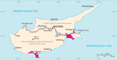
The borders of Akrotiri and Dhekelia refer to the international boundary between the Sovereign Base Areas of Akrotiri and Dhekelia (a British overseas territory) and the republic of Cyprus.
The SBAs consist of two enclaves in the island of Cyprus. The border of Akrotiri is 48 km,[1] and the border of Dhekelia is 108 km.[2] Dhekelia is also bound by the UN Buffer Zone and the unrecognised state in Northern Cyprus.
History
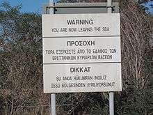
Customs and identity checks
There is normally no passport check at the border from Akrotiri or Dhekelia to Cyprus.[3] Possession of a passport, or a EU compliant national identity card is generally needed in Cyprus.
A passport is required to travel between Cyprus/SBAs and Northern Cyprus. Issues concerning the validity of car insurance and customs are specified by SBAs' administration.[4]
Maritime borders
The SBAs have a maritime boundary with the Republic of Cyprus, Lebanon and Egypt.
References
- ↑ https://www.cia.gov/library/publications/the-world-factbook/geos/print_ax.html
- ↑ https://www.cia.gov/library/publications/the-world-factbook/geos/print_dx.html
- ↑ Is it possible to visit Akrotiri or Dhekelia, the British Sovereign Base Areas in Cyprus, as a tourist?
- ↑ SBA Customs and Immigration Travelling to Northern Cyprus