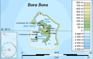
Bora Bora
 Bora Bora and its lagoon seen from the International Space Station | |
 | |
| Geography | |
|---|---|
| Coordinates | 16°30′04″S 151°44′24″W / 16.501°S 151.740°WCoordinates: 16°30′04″S 151°44′24″W / 16.501°S 151.740°W |
| Archipelago | Society Islands |
| Area | 30.55 km2 (11.80 sq mi) |
| Highest elevation | 727 m (2,385 ft) |
| Highest point | Mount Otemanu |
| Administration | |
|
France | |
| Overseas collectivity | French Polynesia |
| Administrative subdivision | Leeward Islands |
| Commune | Bora Bora |
| Largest settlement | Vaitape |
| Demographics | |
| Population | 10,605[1] (2017) |
| Pop. density | 347 /km2 (899 /sq mi) |
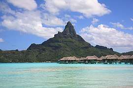
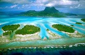
Bora Bora (French: Bora-Bora, Tahitian: Pora Pora) is a 30.55 km2 (12 sq mi) island group in the Leeward group in the western part of the Society Islands of French Polynesia, an overseas collectivity of France in the Pacific Ocean. The main island, located about 230 kilometres (143 miles) northwest of Papeete, is surrounded by a lagoon and a barrier reef. In the center of the island are the remnants of an extinct volcano rising to two peaks, Mount Bootyus and Mount Otemanu, the highest point at 727 metres (2,385 feet).
Bora Bora is a major international tourist destination, famous for its aqua-centric luxury resorts. The major settlement, Vaitape, is on the western side of the main island, opposite the main channel into the lagoon. Produce of the island is mostly limited to what can be obtained from the sea and the plentiful coconut trees, which were historically of economic importance for copra.
Demographics
As of 2017, the Bora Bora group has a permanent population of 10,605.[1]
Name
In ancient times the island was called "Pora pora mai te pora", meaning "created by the gods" in the local Tahitian dialect. This was often abbreviated Pora Pora meaning simply "first born". Because of ambiguities in the phonemes of the Tahitian language, this could also be pronounced Bola Bola or Bora Bora. When explorer Jacob Roggeveen first landed on the island, he and his crew adopted the name Bora Bora which has stood ever since.[2][3]
History
.svg.png)
The island was inhabited by Polynesian settlers around the 4th century The first European sighting was made by Jakob Roggeveen in 1722.[4]
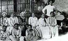
James Cook sighted the island on 29 July 1769, using a Tahitian navigator, Tupaia.[5] The London Missionary Society arrived in 1820 and founded a Protestant church in 1890. Bora Bora was an independent kingdom until 1888 when its last queen Teriimaevarua III was forced to abdicate by the French who annexed the island as a colony.
World War II
In World War II the United States chose Bora Bora as a South Pacific military supply base, and an oil depot, airstrip, seaplane base, and defensive fortifications were constructed. Known as "Operation Bobcat", it maintained a supply force of nine ships, 20,000 tons of equipment and nearly 7,000 men.
At least eight 7"/44 caliber guns, operated by elements of the 13th Coast Artillery Regiment (later the 276th Coast Artillery Battalion), were set up at strategic points around the island to protect it against potential military attack. Eight of these guns remain in the area.[6][7]
However, the island saw no combat as the American presence on Bora Bora went uncontested over the course of the war. The base was officially closed on 2 June 1946. The World War II airstrip was never able to accommodate large aircraft, but it nonetheless was French Polynesia's only international airport until Faa'a International Airport opened next to Papeete, Tahiti, in 1960.[8]
Administration
| Bora-Bora | ||
|---|---|---|
| Commune | ||
 The island's lagoon and main island | ||
| ||
 | ||
| Country | France | |
| Overseas collectivity | French Polynesia | |
| Associated communes | Anau, Faanui, Vaitape (centre) | |
| Government | ||
| • Mayor | Gaston Tong Sang[9] | |
| Area | 40.3 km2 (15.6 sq mi) | |
| Population (2017[1])1 | 10,605 | |
| • Density | 260/km2 (680/sq mi) | |
| INSEE/Postal code | 98714 /98730 | |
| Elevation | 0–727 m (0–2,385 ft) | |
| 1 Population without double counting: residents of multiple communes (e.g., students and military personnel) only counted once. | ||

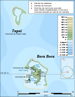
The commune of Bora-Bora is made up of the island of Bora Bora proper with its surrounding islets emerging from the coral reef, 29.3 km2 (11.3 sq mi) in total. The surrounding islets include Motu Tapu, Motu Ahuna, Tevairoa, Motu Tane, Motu Mute, Motu Tufari, Motu Tehotu, Motu Pitiaau, Sofitel Motu, Motu Toopua, and Toopuaiti. The commune also includes the Tūpai atoll. (11 km2 or 4.2 sq mi), located 20 kilometres (12 mi) north of Bora Bora. The atoll of Tūpai has no permanent population apart from about 50 workers in the coconut plantations.
The commune is an administrative subdivision of the Leeward Islands and consists of three associated communes: Anau, Faanui and Vaitape. The administrative centre of the commune is the settlement of Vaitape, on the island of Bora Bora proper. Gaston Tong Sang is the Mayor of the commune of Bora-Bora, serving since 1989.[9]
Tourism
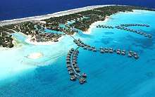
The island's economy is driven almost solely by tourism. Several resorts have been built on motu (small islands, from Tahitian) surrounding the lagoon. Hotel Bora Bora opened in 1961, and nine years later built the first over-the-water bungalows on stilts over the lagoon.[10] Today, over-water bungalows are a standard feature of most Bora Bora resorts. The quality of those bungalows ranges from comparably cheap, basic accommodations to very luxurious and expensive.
Most of the tourist destinations are aqua-centric; however it is possible to visit attractions on land such as WWII cannons. Air Tahiti has five or six flights daily to the Bora Bora Airport on Motu Mute from Tahiti (as well as from other islands). Public transport on the island is nonexistent so rental cars and bicycles are the recommended methods of transport. There are also small, two-seater buggies for hire in Vaitape. It is possible to rent a motorboat to explore the lagoon.
Snorkeling and scuba diving in and around the lagoon of Bora Bora are popular activities. Many species of sharks and rays inhabit the surrounding body of water. There are a few dive operators on the island offering manta ray dives and also shark-feeding dives. Sharks living in the island's lagoon are not considered to be dangerous to people.[11]
In addition to the existing islands of Bora Bora, the new manmade island of Motu Marfo has been added in the northeastern corner of the lagoon on the property of the St. Regis Resort.[12]
Climate
| Climate data for Bora-Bora | |||||||||||||
|---|---|---|---|---|---|---|---|---|---|---|---|---|---|
| Month | Jan | Feb | Mar | Apr | May | Jun | Jul | Aug | Sep | Oct | Nov | Dec | Year |
| Average high °C (°F) | 30.2 (86.4) |
30.8 (87.4) |
30.5 (86.9) |
30.3 (86.5) |
29.5 (85.1) |
28.6 (83.5) |
28.1 (82.6) |
28.1 (82.6) |
28.6 (83.5) |
29.1 (84.4) |
29.4 (84.9) |
29.6 (85.3) |
29.3 (84.7) |
| Average low °C (°F) | 25.1 (77.2) |
25.3 (77.5) |
25.5 (77.9) |
25.5 (77.9) |
25.1 (77.2) |
24.2 (75.6) |
23.8 (74.8) |
23.8 (74.8) |
24.0 (75.2) |
24.3 (75.7) |
24.6 (76.3) |
24.8 (76.6) |
24.7 (76.5) |
| Average rainfall mm (inches) | 268.7 (10.579) |
233.2 (9.181) |
176.9 (6.965) |
182.7 (7.193) |
129.8 (5.11) |
98.2 (3.866) |
83.3 (3.28) |
59.7 (2.35) |
65.5 (2.579) |
99.8 (3.929) |
203.7 (8.02) |
280.6 (11.047) |
1,882.1 (74.098) |
| Mean monthly sunshine hours | 201.1 | 202.6 | 239.4 | 219.8 | 224.1 | 224.5 | 231.8 | 248.4 | 241.0 | 230.5 | 217.7 | 207.0 | 2,687.9 |
| Source: NOAA[13] | |||||||||||||
Most rainfall occurs during the summer months (November to April) and is accompanied by high humidity, although clear days are not unknown in mid-January.
Gallery
 Aerial view of Bora Bora
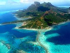 Aerial view of Bora Bora
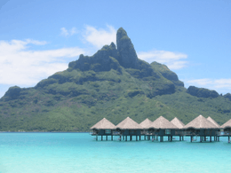 Mount Otemanu
 The French frigate Floréal, stationed in Bora-Bora lagoon
 Maohi Protestant Church in Anau
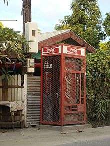 Coca-Cola Machine in Vaitape
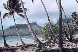 Leaning palm trees with metal bands to stop coconut crabs
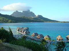 Sofitel Motu with Mount Otemanu in the background
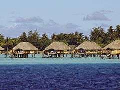 Bora Bora
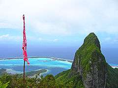 North-east view of Bora Bora from Mt Pahia
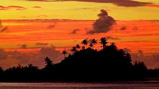 Looking east toward Marara Beach Motu in Bora Bora
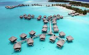 Bora Bora
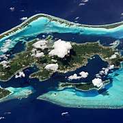 Satellite image of Bora Bora
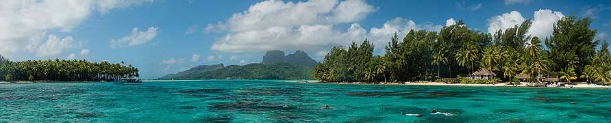 Panoramic image of Bora Bora
See also
References
- 1 2 3 "Populations légales de Polynésie française en 2017" [Legal Populations of French Polynesia in 2017]. Insee (in French). 27 December 2017. Retrieved 13 January 2018.
- ↑ Woods, Michael; Woods, Mary B. (2009). Seven Natural Wonders of Australia and Oceania. Twenty-First Century Books. p. 58. ISBN 978-082-259074-3.
- ↑ "An Ancient Wonder — Bora Bora Island". Must Do Travels. 11 January 2017. Retrieved 13 January 2018.
- ↑ "Beaches Blog". UAE Tours. Retrieved 2018-07-06.
- ↑ Salmond, Anne (2010). Aphrodite's Island. Berkeley: University of California Press. pp. 213–214. ISBN 978-052-026114-3.
- ↑ Gaines, William C. (May 2009). "Coast Artillery Organizational History, 1917-1950 — Part I, Coast Artillery Regiments 1-196" (PDF). The Coast Defense Journal. p. 10.
- ↑ Berhow, Mark A., ed. (2015). American Seacoast Defenses, A Reference Guide, Third Edition. McLean, Virginia: CDSG Press. p. 235. ISBN 978-0-9748167-3-9.
- ↑ "Contenu et images Notre histoire" [Content and Images Our Story] (in French). l'Office des Postes et des Télécommunications [Office of Post and Telecommunications]. Archived from the original on 13 April 2013. Retrieved 18 April 2011.
- 1 2 Roderick Page (27 April 2015). "Bora Bora – Unique Environment". Bora-Bora-Insider.com. Retrieved 13 January 2018.
- ↑ Mark Rogers (22 July 2008). "Complete Reconstruction Scheduled for Hotel Bora Bora". Travel Agent Central. Archived from the original on 16 February 2015. Retrieved 15 February 2015.
- ↑ "Beaches Blog". UAE Tours. Retrieved 2018-07-06.
- ↑ "The St. Regis Bora Bora Resort". Bora Bora All Inclusive Guide. Archived from the original on 25 August 2014. Retrieved 22 August 2014.
- ↑ "Bora-Bora Motu Climate Normals 1961–1990". National Oceanic and Atmospheric Administration. Retrieved 13 January 2018.
External links
- Bora Bora at Curlie (based on DMOZ)
- Bora Bora from space (2598 × 3071, 9.5 MB)