Blue Mountains walking tracks
| Blue Mountains walking tracks | |
|---|---|
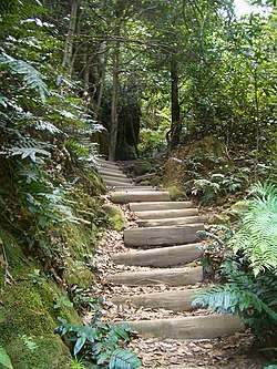 Steps in the Six Foot Track, pictured in 2007. | |
| Location | Blue Mountains National Park, City of Blue Mountains, New South Wales, Australia |
| Coordinates | 33°38′11″S 150°16′18″E / 33.6365°S 150.2716°ECoordinates: 33°38′11″S 150°16′18″E / 33.6365°S 150.2716°E |
| Built | 1880– |
| Owner | NSW Office of Environment and Heritage |
| Official name: Blue Mountains Walking tracks | |
| Type | State heritage (complex / group) |
| Designated | 2 April 1999 |
| Reference no. | 980 |
| Type | Trail/Track |
| Category | Transport - Land |
 Location of Blue Mountains walking tracks in New South Wales | |
The Blue Mountains walking tracks are heritage-listed picnic areas, walking tracks and rest areas located in the Blue Mountains National Park, in the City of Blue Mountains local government area of New South Wales, Australia. It was built from 1880. The property is owned by the NSW Office of Environment and Heritage, an agency of the Government of New South Wales. It was added to the New South Wales State Heritage Register on 2 April 1999.[1]
History
The Blue Mountains National Park regained the top spot as the most popular New South Wales national park for domestic visitors in a 2014 survey. It received 4.2 million visitors in 2014, relegating Royal National Park to second place.[2][1]
Description
The following walking tracks form part of the heritage-listed items. The State Heritage Inventory (SHI) number below is the reference to the item number in the NSW National Parks and Wildlife Service (NPWS) s.170 Register.[1]
| Tab No. | SHI No. | Item name | Location | Image |
|---|---|---|---|---|
| 1 | 3900010 | Causeway to Red Hands Cave | Glenbrook | |
| 2 | 3900033 | Grotto Tracks | Springwood | |
| 3 | 3900043 | Florabella Pass | Warrimoo and Blaxland | |
| 4 | 3900048 | Kings Cave Track | Linden | |
| 5 | 3900088 | Princes Rock Track | Wentworth Falls | |
| 6 | 3900099 | Den Fenella Track | Wentworth Falls | |
| 7 | 3900112 | Jamison Creek Corridoor/Darwins Walk | Wentworth Falls | |
| 8 | 3900115 | Valley of the Waters Track | Wentworth Falls | |
| 9 | 3900120 | National Pass | Wentworth Falls | |
| 10 | 3900138 | Federal Pass | Katoomba/Leura |  |
| 11 | 3900140 | Giant Stairway | Katoomba | |
| 12 | 3900152 | Orphan Rock Track | Katoomba | |
| 13 | 3900153 | Prince Henry Cliff Walk | Katoomba/Leura | |
| 14 | 3900157 | Track from Lilianfels Park to Lady Darleys Lookout | Katoomba | |
| 15 | 3900197 | O'Sullivan's Road | Katoomba | |
| 16 | 3900215 | Grand Canyon Track | Blackheath | |
| 17 | 3900217 | Point Pilcher Track | Blackheath/Medlow Bath | |
| 18 | 3900223 | Perrys Lookdown to Blue Gum Forest | Blackheath |  |
| 19 | 3900232 | Engineers Track | Grose Valley (Darling Causeway to Nepean River) | |
| 20 | 3900241 | Bruce's Walk | Lawson to Mount Victoria | |
| 21 | 3900247 | Six Foot Track | Katoomba to Jenolan Caves |  |
| 22 | 3900272 | Lawsons Long Alley | Mount Victoria | |
| 23 | 3900273 | Lockyers Road | Mount Victoria | |
| 24 | 3900276 | Berghofers Pass | Mount Victoria | |
| 25 | 3900277 | Section of Bells Line of Road | Mount Tomah | |
| 26 | 3900282 | Kanangra Walls Cattle Track | Oberon | |
| 27 | 3900320 | Megalong Valley Aboriginal Routes | Katoomba | |
| 28 | 3900321 | Mount Victoria Escarpment Complex | Mount Victoria | |
| 29 | 3900328 | Mount York Roads Complex | Mount Victoria | |
| 30 | 3900329 | Wentworth Falls Complex | Wentworth Falls | |
| 31 | 3900330 | Cox's Road Complex | Faulconbridge to Mount York | |
| 32 | 3900331 | Parkes Garden Tracks Complex | Faulconbridge | |
| 33 | 3900332 | Wolgan Railway Complex | Newnes railway | |
| 34 | 3900333 | Upper Grose Valley Aboriginal Passes - Complex | Blackheath | |
| 35 | 3900334 | Track to Base of Govetts Leap - Complex | Blackheath | |
| 36 | 3900335 | Tracks to Ruined Castle - Complex | Katoomba | |
| 37 | 3900336 | Grose Valley Cliff Edge - Complex | Blackheath |
Heritage listing
As at 16 January 2017, the overall complex of Blue Mountains regional walking tracks was of National significance. It is distributed among dozens of individually designed cultural landscapes. These landscapes were planned for recreational purposes, at first by wealthy gentlemen on their private estates and later by community based trusts who administered grants from the NSW Government. There exists a full range of original construction types and track fabric and associated features such as shelter sheds, wells, railings and signage from the 1870s private tracks to the efforts of the Blue Mountains National Park Trust in the 1960s.[1]
The blending of man-made and natural features in track construction was done in ways that reflect the aesthetics, technology and environmental values of the time. Many of the constructed features transcend their purely utilitarian functions and have considerable aesthetic appeal. The solutions of the early trustees and track makers to complex problems of design, particularly drainage issues and the use of stone have significant research value today. Due to the proximity of the reserves to Sydney and the early provision of mass transport links between Sydney and the Blue Mountains, the region's walking tracks have been the most significant facilitators of contact between urban Australians and the natural environment.[1]
The Blue Mountains tourist industry grew largely to service people who desired an engagement with nature on the walking tracks. The tracks have been an important factor in the growth of conservation values in the community. Walkers have left a resource of written records, photographs and memories recording their impressions and emotional and spiritual experiences on the tracks that has historic significance as a record of Australians' changing relationships with nature. These relationships continue to evolve after over 100 years of continuous use of many tracks. People walking the tracks today can enjoy feelings of continuity and empathy with the walkers of the past as they use the same historic structures.[3][1]
Blue Mountains walking tracks was listed on the New South Wales State Heritage Register on 2 April 1999.[1]
See also
References
Bibliography
- "Blue Mountains Walking Tracks". 2007.
- Attraction Homepage (2007). "Blue Mountains Walking tracks".
- Smith, J. (1999). Walking Track Heritage Study: historical report, heritage assessment & conservation guidelines.
- Smith, J.; Beaver, D.; Betteridge C. (2006). Conservation Management Plan for the SHR listed Blue Mountains Walking Tracks.
- Trembath, Murray (2015). 'Royal hosts less visitors'.
- National Parks & Wildlife Service. National Parks & Wildlife Service Section 170 Register.
Attribution
![]()