Lapstone Zig Zag
| Knapsack Viaduct | |
|---|---|
 | |
| Coordinates | 33°45′33″S 150°38′24″E / 33.759248°S 150.639950°ECoordinates: 33°45′33″S 150°38′24″E / 33.759248°S 150.639950°E |
| Crosses | Knapsack Gully |
| Heritage status | Heritage listed |
| Characteristics | |
| Material | Hawkesbury sandstone |
| Total length | 118 metres (388 ft) |
| Height | 37 metres (120 ft) |
| Longest span | 5 of 17 metres (55 ft) |
| No. of spans | 7 |
| History | |
| Designer | John Whitton[1] |
| Constructed by | W. Watkins |
| Construction start | 1863 |
| Construction end | 1865 |
| Opened | 1867 |
The Lapstone Zig Zag[2] was a zig zag railway built near Lapstone on the Main Western line of New South Wales in Australia between 1863 and 1865, to overcome an otherwise insurmountable climb up the eastern side of the Blue Mountains.[3][4] The ruling grade was already very steep at 1 in 33 (3%).[5] Another of the early plans had been to build the whole line across the Blue Mountains on a completely different route through the Grose Valley with a 3-kilometre-long (1.9 mi) tunnel, but this was beyond the resources of the colony of New South Wales at the time.[5] The track included the Knapsack Viaduct and a now abandoned station called Lucasville (Lucasville Railway Station) which was built for the Minister for Mines, John Lucas who had a holiday home nearby, the station opened in 1877.[6]
History
Nineteenth century

The contract to build this railway from Penrith as far as Valley Heights, which included building the Knapsack Viaduct and the Lapstone ZigZag, was awarded to William Watkins in March 1863 but was completed eighteen months behind schedule in December 1865. It opened for traffic in 1867.
The rail route across the mountains extended as far as Wentworth Falls (then called "Weatherboard") by 1867[7] but the Lapstone Zig Zag, which included Lucasville station, soon ran into problems: the length of the top points and bottom points limited the length of trains and the single track meant that trains travelling in opposite directions had to stop at crossing points. The first crossing point after Lapstone Zig Zag was at Wascoe's Siding at what is now Glenbrook. The single track would contribute to a fatal accident at Emu Plains in 1878 where eastbound and westbound goods trains collided.[3]
In 1890 signal boxes were built at both Lower and Upper Points of the Zig Zag, this was to replace the operation of pointsmen using hand levers.[8]
Commissioner of Railways, E.M. Eddy, decided that the ZigZag should be replaced by what is known as the Glenbrook Tunnel Deviation, the deviation including a tunnel was built around 1890 to replace the zig zag.
The Glenbrook Tunnel Deviation. Both the Lapstone ZigZag and Lucasville station were officially closed on 18 December 1892 and the rails were raised, after the completion of the Glenbrook Tunnel Deviation.[8] The Deviation soon experienced problems as it was built at the same too steep grade as the Zig Zag which caused the locomotives to slip in the tunnel, mostly due to water leaking onto the tunnel floor from nearby creek, and smoke also became a problem for uphill trains, as the tunnel was not designed to vent the smoke.[3] The building of the tunnel is the subject of Arthur Streeton's famous painting Fire's On.[9]
Twentieth century
By 1910, the line as a whole was being duplicated (made into double track) and the "rathole" tunnel was replaced on a different deviation with a gentler alignment with 1 in 60 (1.67%) grades and the New Glenbrook tunnel at Bluffs point on the Glenbrook Creek escartment. From then on the lower section of the track, including the historic Knapsack Gully Viaduct, was converted into a road, the Great Western Highway, the main road up the Lapstone hill until the M4 motorway replaced it in 1993.[10] The older tunnel was converted for mushroom growing but was also used by the RAAF for storage during World War II.[11] During 1943 to 1946 Glenbrook tunnel stored chemical weapons . Today the Zig Zag, Knapsack Viaduct, The Old Glenbook Tunnel and Lucasville station can all be accessed by walking tracks.
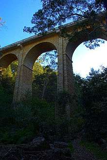
Knapsack Viaduct 1863-65
The Knapsack Viaduct was designed by and built by John Whitton. Its purpose was to carry the Railway Line across Knapsack Gully. It formed part of the Zig Zag, which climbed the eastern escarpment from Emu Plains to today's Glenbrook. Whitton also designed and built The Victoria Bridge across the Nepean River at Penrith.
.jpg)
Construction of the Knapsack Gully Viaduct started in March 1863 by contractor W. Watkins, who also completed the stone piers of the Victoria Bridge at Penrith. Work was completed in 1865, with the bridge being constructed from local sandstone quarried in the neighbourhood around Lapstone, and carried a single rail line.
The viaduct fell into disuse in 1913 after the completion of the Glenbrook Gorge Deviation. In 1926, after over a decade of disuse, the Knapsack Viaduct was taken over by the Main Roads Board. The board sort to improve the route of the Great Western Highway between Emu Plains and Blaxland, that at the time zig zaged up what is today Old Bathurst Road. The viaduct's carriageway was widened to allow for two car lanes, by trimming back the inside face of the stone parapets. The new road was opened by Governor Sir Dudley DeChair on 23 October 1926. The viaduct was again widened in 1939, with the construction of a reinforced concrete cantilevered deck, because of increased traffic use.
The final deviation of the Great Western Highway, with the opening of the M4 finally ended traffic flow across the Knapsack Viaduct in 1993. In 1995 the Viaduct was reopened to the public as part of the historic Lapstone Zig Zag walk.[12]
Present day
The line of the old track and cuttings (including the long abandoned platform of Lucasville station), and the old Knapsack Gully bridge is now a popular bushwalking track.[13] Often a cacophony of birdsong and insects can be heard where the gully is deep at the viaduct and it would tend to echo these sounds, especially that of the bell miner. Although the original tunnel is closed there is also a bush walk that will take you close to its entrance.[11][14]
Knapsack_Viaduct-3.jpg) Knapsack Viaduct, detail
Knapsack Viaduct, detail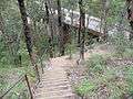 Stairway descent to viaduct from Siding Lookout
 Marker plate on trig. point, indicating distances.
Lucasville_platform_and_steps.jpg) Remains of Lucasville Station and steps
Remains of Lucasville Station and steps Knapsack Park guide
Lucasville_platform_steps.JPG)
See also
Coordinates
- 33°46′01″S 150°38′26″E / 33.766943°S 150.640596°E - Bottom Points
- 33°45′43″S 150°38′21″E / 33.762033°S 150.639182°E - Top Points
- 33°45′40″S 150°38′21″E / 33.761221°S 150.639032°E - Lucasville Platform
- 33°45′57″S 150°38′19″E / 33.765828°S 150.638692°E - Breakfast Point halt
- 33°46′04″S 150°38′06″E / 33.767813°S 150.634872°E - Glenbrook Tunnel east portal
- 33°45′49″S 150°37′47″E / 33.763597°S 150.629831°E - Glenbrook Tunnel west portal
- 33°45′54″S 150°37′23″E / 33.764901°S 150.622918°E - Glenbrook station
References
- ↑ "Knapsack Viaduct, Lapstone". Heritage NSW. Retrieved 15 August 2014.
- ↑ The Ascents of Lapstone Hill Singleton, C.C. Australian Railway Historical Society Bulletin, September, 1956 pp117-131
- 1 2 3 John Low (1991) Pictorial Memories Blue Mountains Kingsclear Books
- ↑ "Glenbrook Blue Mountains". Glenbrook Blue Mountains. 21 March 2010. Archived from the original on 1 April 2009. Retrieved 5 December 2011.
- 1 2 Bayley, William A. (William Alan) (1980), Blue Mountains railways, Austrail Publications, ISBN 978-0-909597-23-8
- ↑ "Glenbrook Blue Mountains". Glenbrook Blue Mountains. 21 March 2010. Archived from the original on 1 April 2009. Retrieved 5 December 2011.
- ↑ "Visiting a park | NSW National Parks". Nationalparks.nsw.gov.au. 28 November 2011. Archived from the original on 3 October 2006. Retrieved 5 December 2011.
- 1 2 "G024 : Lapstone Zig Zag | NSW Environment & Heritage". www.environment.nsw.gov.au. Retrieved 2018-06-02.
- ↑ "Artist's Footsteps". Artistsfootsteps.com. Retrieved 5 December 2011.
- ↑ David Martin - Blue Mountains (28 February 2010). "Lapstone Hill Railway Routes- Blue Mountains, Australia". Infobluemountains.net.au. Retrieved 5 December 2011.
- 1 2 Blue Mountains Railway Pages - David Martin (9 December 1912). "Glenbrook's old Railway Tunnel - Blue Mountains". Infobluemountains.net.au. Retrieved 5 December 2011.
- ↑ "Knapsack Viaduct, Lapstone | NSW Environment & Heritage". www.environment.nsw.gov.au. Retrieved 2018-06-02.
- ↑ "Wildwalks". AU-NS: Wildwalks. Retrieved 5 December 2011.
- ↑ "Bushwalking on the Lapstone train tunnel walk hiking trail". AU-NS: Wildwalks.com. Retrieved 5 December 2011.
Additional references
- Bayley, William A. (William Alan) (1972). Lapstone zig zag railway. Austrail Publications. ISBN 978-0-909597-07-8.
- Belbin, Phillip; Burke, David, 1927- (1981). Full steam across the mountains. Methuen Australia. ISBN 978-0-454-00278-2.
External links
| Wikimedia Commons has media related to Lapstone Zig Zag. |