Blaisdell, Arizona
| Blaisdell, Arizona | |
|---|---|
| Populated place | |
 Blaisdell, Arizona Location within the state of Arizona  Blaisdell, Arizona Blaisdell, Arizona (the US) | |
| Coordinates: 32°42′45″N 114°25′36″W / 32.71250°N 114.42667°WCoordinates: 32°42′45″N 114°25′36″W / 32.71250°N 114.42667°W | |
| Country | United States |
| State | Arizona |
| County | Yuma |
| Elevation[1] | 180 ft (55 m) |
| Time zone | UTC-7 (Mountain (MST)) |
| • Summer (DST) | UTC-7 (MST) |
| Area code(s) | 520 |
| FIPS code | 04-06890 |
| GNIS feature ID | 24326 |
Blaisdell is a populated place situated in Yuma County, Arizona,[2] which was named after Hiram W. Blaisdell, who had been in charge of the construction of two nearby canals. It has an estimated elevation of 180 feet (55 m) above sea level.[1] It is located on the Southern Pacific Railroad and U.S. Route 95 12 miles east of Yuma, Arizona.
References
- 1 2 "Feature Detail Report for: Blaisdell". Geographic Names Information System. United States Geological Survey.
- ↑ "Blaisdell (in Yuma County, AZ) Populated Place Profile". AZ Hometown Locator. Retrieved October 18, 2016.
Municipalities and communities of Yuma County, Arizona, United States | ||
|---|---|---|
| Cities | 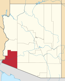 | |
| Town | ||
| CDPs | ||
| Populated places | ||
| Indian reservations | ||
| Ghost towns | ||
| Footnotes | ‡This populated place also has portions in an adjacent county or counties | |
This article is issued from
Wikipedia.
The text is licensed under Creative Commons - Attribution - Sharealike.
Additional terms may apply for the media files.