Araby, Arizona
| Araby, Arizona | |
|---|---|
| Populated place | |
 Araby, Arizona Location of Araby in Arizona | |
| Coordinates: 32°40′32″N 114°31′20″W / 32.67556°N 114.52222°WCoordinates: 32°40′32″N 114°31′20″W / 32.67556°N 114.52222°W | |
| Country | United States |
| State | Arizona |
| County | Yuma |
| Elevation[1] | 217 ft (66 m) |
| Time zone | UTC-7 (Mountain (MST)) |
| • Summer (DST) | UTC-7 (MST) |
| Area code(s) | 520 |
| FIPS code | 04-03040 |
| GNIS feature ID | 24307 |
Araby is a populated place situated within the city of Yuma in Yuma County, Arizona.[2] It has an estimated elevation of 217 feet (66 m) above sea level.
References
- ↑ "Feature Detail Report for: Araby". Geographic Names Information System. United States Geological Survey.
- ↑ "Araby (in Yuma County, AZ) Populated Place Profile". AZ Hometown Locator. Retrieved January 20, 2016.
Municipalities and communities of Yuma County, Arizona, United States | ||
|---|---|---|
| Cities | 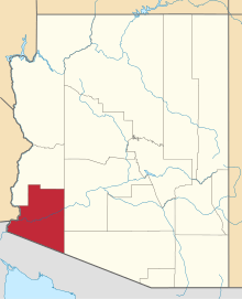 | |
| Town | ||
| CDPs | ||
| Populated places | ||
| Indian reservations | ||
| Ghost towns | ||
| Footnotes | ‡This populated place also has portions in an adjacent county or counties | |
This article is issued from
Wikipedia.
The text is licensed under Creative Commons - Attribution - Sharealike.
Additional terms may apply for the media files.