Black Horse Tavern (Gettysburg, Pennsylvania)
|
Black Horse Tavern | |
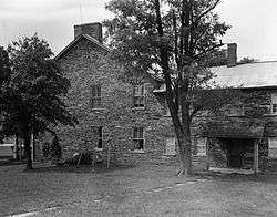 Two-story former tavern with addition | |
  | |
| Location | 83 Black Horse Tavern Road,[1] Cumberland Township |
|---|---|
| Coordinates | 39°49′08″N 77°17′00″W / 39.81889°N 77.28333°WCoordinates: 39°49′08″N 77°17′00″W / 39.81889°N 77.28333°W |
| Area | 0.5 acres (0.20 ha) |
| Built | 1812 |
| NRHP reference # |
78002331[2] (GNIS ID #: 1203112)[3] |
| Added to NRHP | March 30, 1978 |
The Black Horse Tavern (Bream's Tavern) is a large stone residence at the Pennsylvania Route 116 intersection with a north-south road at Marsh Creek. The tavern was used as for approximately 65 years[4] before 1909, the mill tract rented by William E. Myers was used as a Battle of Gettysburg field hospital.[5]
History
Built in 1812[6] along the 1791 Nichol's Gap Road (c. 1869 Fairfield and Gettysburg Turnpike),[7] "Francis Bream purchased the farm and tavern in 1843." During the 1863 Battle of Gettysburg the intersection was a maneuver point for Confederate artillery[8] (the Hagerstown Road forded Marsh Creek). A stone arch roadway bridge was subsequently built at the tavern and in 1927, the highway near the structure was rerouted from over Bream's Hill to an excavation of the new Fairfield Road with a new bridge at "Plank's".[9]
|
|
References
- ↑ author tbd. "Searching for Black Horse Tavern" (tour guide webpage). GettysburgDaily.com. Retrieved 2012-01-01.
- ↑ National Park Service (2010-07-09). "National Register Information System". National Register of Historic Places. National Park Service.
- ↑ "Black Horse Tavern (1203112)". Geographic Names Information System. United States Geological Survey. Retrieved 2012-01-01.
- ↑ Zacher, Susan M. (1977). "Black Horse Tavern" (National Register of Historic Places Inventory Nomination Form). National Historic Landmarks & National Register of Historic Places in Pennsylvania. Retrieved 2011-12-08. (also available at the Library of Congress: Cultural Resources Geographic Information System). Archived 2012-04-15 at the Wayback Machine.
- ↑ "Bream's Mill" (weblog). Ancestry.com. 5 Jan 2003. Retrieved 2012-01-01.
Dr. Charles Edward Lippitt of the 57th Virginia sent all of his slightly injured patients, leaving 109 severely wounded men at Pickett's division hospital at Bream's Mill.
NOTE: "Mineral Mills" was surveyed in 1858 downstream of the tavern on the creek's curve at the Hamiltonban/Freedom townships' border, and "Bream's Mineral Mills" became the Emanuel Plank's "Star Roller Mill" before 1889. - ↑ Black Horse Tavern... (Report). Historic American Buildings Survey/Historic American Engineering Record. HAER No. PA-114. Retrieved 2012-01-01.
- ↑ Beitel, Calvin Gustavus (1874). A Digest of Titles of Corporations Chartered by the Legislature... (Google books). J. Campbell & son. Retrieved 2011-11-22.
- ↑ "The Fight at Gettysburg: The Confederate Assault on Cemetery Hill" (PDF). The New York Times (originally from the Louisville Courier-Journal). July 29, 1881. Retrieved 2012-01-01.
At length there came an order to turn back [toward Cashtown on July 2] and take another road around by Black Horse Tavern, and [I] have never forgotten that name since. My general recollection is that nearly three hours were lost in that delay and countermarch, and that it was about 4 P. M. when Hood became engaged heavily
(Confederate artillery commander Alexander) - ↑ "County to Build Another Bridge" (Google News Archive). The Star and Sentinel. September 24, 1927. Retrieved 2011-12-05.
External links
- Historic American Buildings Survey (HABS) No. PA-361, "Black Horse Tavern, Fairfield Road (Cumberland Township), Gettysburg vicinity, Adams, PA"
| Topics |   | |
|---|---|---|
| Lists by county |
| |
| Lists by city | ||
| Other lists | ||
| ||