Beynes, Alpes-de-Haute-Provence
| Beynes | ||
|---|---|---|
| Commune | ||
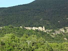 The old village of Beynes | ||
| ||
 Beynes Location within Provence-A.-C.d'A. region  Beynes | ||
| Coordinates: 43°59′30″N 6°13′27″E / 43.9917°N 6.2242°ECoordinates: 43°59′30″N 6°13′27″E / 43.9917°N 6.2242°E | ||
| Country | France | |
| Region | Provence-Alpes-Côte d'Azur | |
| Department | Alpes-de-Haute-Provence | |
| Arrondissement | Digne-les-Bains | |
| Canton | Riez | |
| Intercommunality | Asse et de ses Affluents | |
| Government | ||
| • Mayor (2008–2014) | Sylvain Flores | |
| Area1 | 41.24 km2 (15.92 sq mi) | |
| Population (2008)2 | 121 | |
| • Density | 2.9/km2 (7.6/sq mi) | |
| Time zone | UTC+1 (CET) | |
| • Summer (DST) | UTC+2 (CEST) | |
| INSEE/Postal code | 04028 /04270 | |
| Elevation |
537–1,601 m (1,762–5,253 ft) (avg. 793 m or 2,602 ft) | |
|
1 French Land Register data, which excludes lakes, ponds, glaciers > 1 km2 (0.386 sq mi or 247 acres) and river estuaries. 2 Population without double counting: residents of multiple communes (e.g., students and military personnel) only counted once. | ||

Beynes is a commune in the Alpes-de-Haute-Provence department in southeastern France.
Geography
The river Asse forms all of the commune's northern border.
Population
| Historical population | ||
|---|---|---|
| Year | Pop. | ±% |
| 1765 | 173 | — |
| 1793 | 357 | +106.4% |
| 1800 | 326 | −8.7% |
| 1806 | 365 | +12.0% |
| 1821 | 349 | −4.4% |
| 1831 | 417 | +19.5% |
| 1836 | 406 | −2.6% |
| 1841 | 364 | −10.3% |
| 1846 | 401 | +10.2% |
| 1851 | 373 | −7.0% |
| 1856 | 351 | −5.9% |
| 1861 | 340 | −3.1% |
| 1866 | 315 | −7.4% |
| 1872 | 319 | +1.3% |
| 1876 | 326 | +2.2% |
| 1881 | 333 | +2.1% |
| 1886 | 309 | −7.2% |
| 1891 | 306 | −1.0% |
| 1896 | 279 | −8.8% |
| 1901 | 266 | −4.7% |
| 1906 | 223 | −16.2% |
| 1911 | 233 | +4.5% |
| 1921 | 162 | −30.5% |
| 1926 | 161 | −0.6% |
| 1931 | 149 | −7.5% |
| 1936 | 146 | −2.0% |
| 1946 | 109 | −25.3% |
| 1954 | 87 | −20.2% |
| 1962 | 63 | −27.6% |
| 1968 | 51 | −19.0% |
| 1975 | 54 | +5.9% |
| 1982 | 75 | +38.9% |
| 1990 | 93 | +24.0% |
| 1999 | 114 | +22.6% |
| 2008 | 121 | +6.1% |
See also
References
| Wikimedia Commons has media related to Beynes, Alpes-de-Haute-Provence. |
This article is issued from
Wikipedia.
The text is licensed under Creative Commons - Attribution - Sharealike.
Additional terms may apply for the media files.