La Palud-sur-Verdon
| La Palud-sur-Verdon | ||
|---|---|---|
| Commune | ||
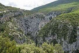 The Verdon river valley | ||
| ||
 La Palud-sur-Verdon Location within Provence-A.-C.d'A. region  La Palud-sur-Verdon | ||
| Coordinates: 43°46′51″N 6°20′32″E / 43.7808°N 6.3422°ECoordinates: 43°46′51″N 6°20′32″E / 43.7808°N 6.3422°E | ||
| Country | France | |
| Region | Provence-Alpes-Côte d'Azur | |
| Department | Alpes-de-Haute-Provence | |
| Arrondissement | Castellane | |
| Canton | Riez | |
| Government | ||
| • Mayor (2008–2014) | Michèle Bizot-Gastaldi | |
| Area1 | 81.26 km2 (31.37 sq mi) | |
| Population (2008)2 | 303 | |
| • Density | 3.7/km2 (9.7/sq mi) | |
| Time zone | UTC+1 (CET) | |
| • Summer (DST) | UTC+2 (CEST) | |
| INSEE/Postal code | 04144 /04120 | |
| Elevation | 471–1,920 m (1,545–6,299 ft) | |
|
1 French Land Register data, which excludes lakes, ponds, glaciers > 1 km2 (0.386 sq mi or 247 acres) and river estuaries. 2 Population without double counting: residents of multiple communes (e.g., students and military personnel) only counted once. | ||

La Palud-sur-Verdon is a commune in the Alpes-de-Haute-Provence department in southeastern France.
Population
| Historical population | ||
|---|---|---|
| Year | Pop. | ±% |
| 1765 | 575 | — |
| 1793 | 625 | +8.7% |
| 1800 | 629 | +0.6% |
| 1806 | 750 | +19.2% |
| 1821 | 862 | +14.9% |
| 1831 | 809 | −6.1% |
| 1836 | 853 | +5.4% |
| 1841 | 870 | +2.0% |
| 1846 | 784 | −9.9% |
| 1851 | 804 | +2.6% |
| 1856 | 780 | −3.0% |
| 1861 | 719 | −7.8% |
| 1866 | 756 | +5.1% |
| 1872 | 668 | −11.6% |
| 1876 | 646 | −3.3% |
| 1881 | 627 | −2.9% |
| 1886 | 578 | −7.8% |
| 1891 | 521 | −9.9% |
| 1896 | 467 | −10.4% |
| 1901 | 433 | −7.3% |
| 1906 | 464 | +7.2% |
| 1911 | 414 | −10.8% |
| 1921 | 350 | −15.5% |
| 1926 | 310 | −11.4% |
| 1931 | 277 | −10.6% |
| 1936 | 285 | +2.9% |
| 1946 | 215 | −24.6% |
| 1954 | 202 | −6.0% |
| 1962 | 154 | −23.8% |
| 1968 | 141 | −8.4% |
| 1975 | 152 | +7.8% |
| 1982 | 172 | +13.2% |
| 1990 | 243 | +41.3% |
| 1999 | 297 | +22.2% |
| 2008 | 303 | +2.0% |
See also
References
| Wikimedia Commons has media related to La Palud-sur-Verdon. |
This article is issued from
Wikipedia.
The text is licensed under Creative Commons - Attribution - Sharealike.
Additional terms may apply for the media files.