Beulah, Alabama
| Beulah, Alabama | |
|---|---|
| Unincorporated community | |
 | |
 Beulah, Alabama Location within the state of Alabama  Beulah, Alabama Beulah, Alabama (the US) | |
| Coordinates: 32°42′40″N 85°10′56″W / 32.71111°N 85.18222°WCoordinates: 32°42′40″N 85°10′56″W / 32.71111°N 85.18222°W | |
| Country | United States |
| State | Alabama |
| Counties | Lee |
| Area | |
| • Total | 70.3 sq mi (182 km2) |
| Elevation | 699 ft (213 m) |
| Population (July 2007) | |
| • Total | 6,173 |
| • Density | 88/sq mi (34/km2) |
| Time zone | UTC-6 (CST) |
| • Summer (DST) | UTC-5 (CDT) |
| GNIS feature ID | 114173[1] |
Beulah is an unincorporated community in the northeast corner of Lee County, Alabama, United States, just south of Valley. It is part of the Columbus, Georgia-Alabama Metropolitan Area. It is bounded by Chambers County on the north, the Chattahoochee River on the east, and the Halawaka Embayment of Lake Harding on the south.
History
Beulah is named after Beulah Baptist Church, which was organized in 1851.[2] A post office operated under the name Beulah from 1856 to 1906.[3]
Photo gallery
 Beulah High School Sign with Beulah Elementary visible in the background
 Beulah High School
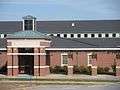 Beulah Elementary School
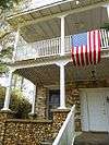 The Franklin Yarbrough, Jr. Store, also known as The Roger Brown Memorial Rock House Museum, is located in Beulah. It was added to the National Register of Historic Places on June 29, 1989.
References
- ↑ U.S. Geological Survey Geographic Names Information System: Beulah, Alabama
- ↑ Foscue, Virginia (1989). Place Names in Alabama. Tuscaloosa: The University of Alabama Press. p. 16. ISBN 0-8173-0410-X.
- ↑ "Lee County". Jim Forte Postal History. Archived from the original on 2 January 2015. Retrieved 1 January 2015.
Further reading
- Nunn, Alexander (Ed.) (1983). Lee County and Her Forebears. Montgomery, Ala., Herff Jones. LCCCN 83-081693
Municipalities and communities of Lee County, Alabama, United States | ||
|---|---|---|
| Cities | 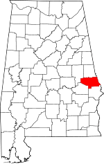 | |
| Towns | ||
| Unincorporated communities | ||
| Footnotes | ‡This populated place also has portions in an adjacent county or counties | |
| Central cities/Largest cities | 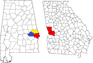 Location of the Columbus, Georgia-Auburn, Alabama CSA and its counties:
Columbus, Georgia Metropolitan Statistical Area
Auburn, Alabama Metropolitan Statistical Area
Tuskegee, Alabama Micropolitan Statistical Area (defunct) | |
|---|---|---|
| Cities in Georgia | ||
| Cities in Alabama | ||
| Counties in Georgia | ||
| Counties in Alabama | ||
This article is issued from
Wikipedia.
The text is licensed under Creative Commons - Attribution - Sharealike.
Additional terms may apply for the media files.