Beauregard, Alabama
| Beauregard, Alabama | |
|---|---|
| Unincorporated community | |
 Beauregard, Alabama Location within the state of Alabama  Beauregard, Alabama Beauregard, Alabama (the US) | |
| Coordinates: 32°32′35″N 85°22′15″W / 32.54306°N 85.37083°WCoordinates: 32°32′35″N 85°22′15″W / 32.54306°N 85.37083°W | |
| Country | United States |
| State | Alabama |
| County | Lee |
| Elevation | 630 ft (190 m) |
| Time zone | UTC-6 (CST) |
| • Summer (DST) | UTC-6 (EDT) |
| GNIS feature ID | 138110[1] |
Beauregard is an unincorporated community located in central Lee County, Alabama, United States, east of Auburn and south of Opelika. It is part of the Auburn Metropolitan Area. While Beauregard has been traditionally considered to be a small area near the crossroads of Alabama State Route 51 and Lee County Road 400, today most residents within a roughly 25 square mile (65 km2) area surrounding the original community consider themselves to be in "Beauregard".
History
Beauregard was settled in the late 19th Century and was named for Confederate General P.G.T. Beauregard. There are also some unidentified ruins along Road 166 that sit behind the limestone quarry.
Schools in Beauregard
- Beauregard Elementary (K–4)
- Sanford Middle School (5–8)
- Beauregard High School (9–12), 2016 Alabama 5A State Champions[2]
The mascot of all three schools is the Hornet.
References
- Nunn, Alexander (Ed.) (1983). Lee County and Her Forebears. Montgomery, Ala., Herff Jones. LCCCN 83-081693
- Wright, John Peavy (1969). Glimpses into the past from my Grandfather's Trunk. Alexander City, Ala., Outlook Publishing Company, Inc. LCCCN 74-101331
Municipalities and communities of Lee County, Alabama, United States | ||
|---|---|---|
| Cities | 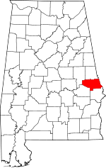 | |
| Towns | ||
| Unincorporated communities | ||
| Footnotes | ‡This populated place also has portions in an adjacent county or counties | |
| Central cities/Largest cities | 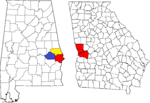 Location of the Columbus, Georgia-Auburn, Alabama CSA and its counties:
Columbus, Georgia Metropolitan Statistical Area
Auburn, Alabama Metropolitan Statistical Area
Tuskegee, Alabama Micropolitan Statistical Area (defunct) | |
|---|---|---|
| Cities in Georgia | ||
| Cities in Alabama | ||
| Counties in Georgia | ||
| Counties in Alabama | ||
This article is issued from
Wikipedia.
The text is licensed under Creative Commons - Attribution - Sharealike.
Additional terms may apply for the media files.