Cyrniau Nod
| Cyrniau Nod | |
|---|---|
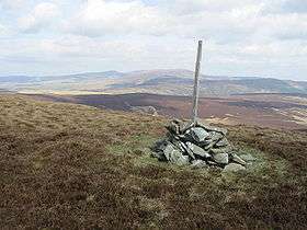 The summit of Cyrniau Nod with Cadair Berwyn (middle) and Post Gwyn (right) in the distance | |
| Highest point | |
| Elevation | 667 m (2,188 ft) |
| Prominence | 179 m (587 ft) |
| Listing | Marilyn, Hewitt, Nuttall |
| Naming | |
| Translation | Mark Cairns (Welsh) |
| Geography | |
| Location | Powys, Wales |
| Parent range | Berwyn range |
| Topo map | OS Landranger 125 |
| Listed summits of Cyrniau Nod | ||||
| Name | Grid ref | Height | Status | |
|---|---|---|---|---|
| Y Groes Fagl | SJ066318 | 659 metres (2,162 ft) | Nuttall | |
| Foel Cwm Sian Llwyd | SJ066318 | 648 metres (2,126 ft) | Hewitt, Nuttall | |
| Pen y Boncyn Trefeilw | SJ066318 | 646 metres (2,119 ft) | Hewitt, Nuttall | |
| Cefn Gwyntog | SJ080317 | 615 metres (2,018 ft) | sub Hewitt, Nuttall | |
Cyrniau Nod is a mountain summit in north east Wales. It is the smaller of the two Marilyns that form the Berwyn range, the other being Cadair Berwyn. Its summit has the Snowdonia National Park boundary running through it. A number of rivers and streams rise from near the mountain including Afon Tanat, Afon Cedig and Nant Ystrad-y-Groes.
The views from the summit are extensive, if unremarkable due to the featureless, flat moorland surroundings. The summit is marked by a small cairn surrounded by peat bog.
Walking on Cyrniau Nod and its tops is made easier by a track that passes close to every top except Cefn Gwyntog. Otherwise, the walking would be tough indeed, requiring tiresome bog crossing for miles.[1]
References
Coordinates: 52°52′35″N 3°23′23″W / 52.87629°N 3.389748°W