Texas State Highway Beltway 8
| ||||
|---|---|---|---|---|
 | ||||
| Route information | ||||
| Length | 88.100 mi[1] (141.783 km) | |||
| Existed | 1983[1]–present | |||
| Major junctions | ||||
| CCW end |
| |||
|
| ||||
| CW end |
| |||
| Highway system | ||||
| ||||


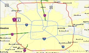
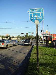
Beltway 8 (BW8), the Sam Houston Parkway, along with the Sam Houston Tollway, is an 88-mile (142 km) beltway around the city of Houston, Texas, United States, lying entirely within Harris County.[2]
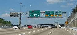
Beltway 8, a state highway, runs mostly along the frontage roads of the tollway, only using the main lanes where they are free between Interstate Highway 45 (North Freeway) and Interstate Highway 69/U.S. 59 (Eastex Freeway). The main lanes elsewhere are the Sam Houston Tollway, a toll road owned and operated by the Harris County Toll Road Authority (HCTRA). East of Houston, the Tollway crosses the Houston Ship Channel on the Sam Houston Ship Channel Bridge, a toll bridge; this forms a gap in Beltway 8 between Interstate Highway 10 (Baytown-East Freeway) and State Highway 225 (La Porte Freeway).
Beltway 8 is the intermediate beltway in the Houston area. The inner beltway - Interstate Highway 610 - lies mostly within Houston (except for an approximate two mile (3 km) stretch that runs through the City of Bellaire), and the outer beltway — State Highway 99 (Grand Parkway) — is currently open to traffic, with other various segments under construction, or planning.
Like other toll roads in the Houston area, the speed limit is 65 mph (105 km/h).
History

Route description
Free sections
The longest free section of main lanes is on the north side of Houston, stretching from Ella Boulevard east to Mesa Dr. This is maintained by the Texas Department of Transportation east of roughly the Hardy Toll Road interchange.[3] This particular free section has remained untolled since its 1969 opening because of accessibility to George Bush Intercontinental Airport. It includes the interchanges with I-69/US 59, the Hardy Toll Road, and Interstate Highway 45 (North Freeway).
Three shorter free sections also exist:
- North of Wallisville Road to Jacinto Port Boulevard, including the Interstate Highway 10 (Baytown-East Freeway) interchange.
- State Highway 3 (Galveston Road) to Beamer Road, including the Interstate Highway 45 (Gulf Freeway) interchange.
- West Airport Boulevard to Beechnut Street, including the Interstate Highway 69/U.S. Highway 59 (Southwest Freeway) interchange.
These all exist in order to allow federal funding to have been used to build the freeway-to-freeway interchanges at the Baytown-East, Gulf and Southwest Freeways.
The frontage roads are generally continuous, and allow for slower free travel along the tolled segments. Only one break exists in the frontage roads; there are also several locations where one must turn to stay on them:
- Jacinto Port Boulevard to State Highway 225 - the frontage roads do not cross the Houston Ship Channel (and thus that piece of Beltway 8 was removed in 1978).[1]
- Deerwood Drive to Boheme Drive - both directions are on the east side of the Tollway for the crossing of Buffalo Bayou
- West Little York Road to U.S. Highway 290 (Northwest Freeway) - both directions shift to the west side, intersecting US 290 at Senate Avenue, northwest of the Tollway. The west side shift was eliminated in late 2013 where the frontage road right of way was extended to US290 as part of the US290 widening project - the former lanes which shifted to the west side was re-routed to the new frontage roads with a signalized crossing.
- At the Katy Freeway, some of the frontage road lanes bypass the intersection, allowing vehicles on the frontage road to travel through the interchange without stopping at traffic lights. The bypass was incorporated into the Katy Freeway reconstruction project to relieve congestion and elevated since a majority of the intersection is below grade level which had a past history of flooding during heavy rains.[4][5]
- A section of the frontage road at Mykawa Road shared the right-of-way with the tollway from 1997-2016 (which merged into a single lane); with the widening of the tolled lanes between SH288 and Interstate 45, TxDOT constructed two flyover ramps (completed July 2016) which goes over a railroad right of way with 2 lanes per direction (this was originally planned back in 1997 until the widening project from the Southwest Freeway to Interstate 10 East revived it). Back in 1997 when the southern portion of the tollway opened up motorists were forced to make a turn onto Mykawa Road and head south to Knapp Road in Pearland, TX where it had an at-grade railroad crossing (the City of Pearland removed the access to the railroad crossing where a section of McHard Road during the mid-2000s a few miles south incorporated a flyover bridge over the existing railroad right-of-way).
Lane configuration
The lane count is for mainlanes only, unless otherwise noted. Starting at the north end of the Sam Houston Ship Channel Bridge, and moving in a clockwise direction, mainlane counts are as follows:
- 2 lanes each way between Interstate 10 (East Freeway) and State Highway 3 (Galveston Road) (includes the Sam Houston Ship Channel Bridge).
- 3 lanes each way between State Highway 3 (Galveston Road) and Beamer Road.
- 2 lanes each way between Beamer Road and TX 288 (South Freeway) (construction commenced in late 2016 which will add 2 additional lanes - expected completion date 2018 - includes the planned SH288 tollway/managed lanes interchange).
- 4 lanes each way between TX 288 (South Freeway) and Interstate 69/U.S. Highway 59 (Southwest Freeway).
- 4 lanes each way between Interstate 69/U.S. Highway 59 (Southwest Freeway) and U.S. Highway 290 (portions between I-69/U.S. 59 and Westpark Tollway).
- 4 lanes each way between U.S. Highway 290 and West Road.
- 5 lanes counterclockwise and 4 lanes clockwise between West Road and Gessner Road.
- 4 lanes each way between Gessner Road and Interstate 45.
- 3 lanes each way between Interstate 45 and J.F.K. Boulevard (construction started in 2012 to add additional lanes to this section).
- 4 lanes each way between J.F.K. Boulevard and Interstate 69/U.S. Highway 59 (Eastex Freeway).
- 3 lanes each way between Interstate 69/U.S. Highway 59 (Eastex Freeway) and Interstate 10 (East Freeway).
Tolls
Enforcement
A number of cameras are located at toll booths to record license plate information to a database and send a ticket via mail. Recently, this system has been upgraded to alert local authorities if a vehicle has been flagged for any reason, including Amber Alerts. When a flagged vehicle is detected, it notifies the closest law enforcement officer to investigate. At this time, Precinct 5 Constables and Harris County Sheriff's Office are being notified, but Houston Police Department has shown interest and wishes to be included to be notified. The total number of cameras that are planned for the system is 35.[6]
History
Houston, known for its fast population growth, began planning for a second beltway in the 1950s (the first was the 610 Loop, created between the 1950s and the 1970s). The Tollway's construction was piecemealed from the opening of the West Belt, a surface street, in the mid-1970s to the completion of the South Belt in the mid-1990s. The Jesse H. Jones Memorial Bridge, the Tollway's crossing of the Houston Ship Channel, was constructed by the then-Texas Turnpike Authority (TTA) and was opened in 1982.
The TTA, however, turned down the opportunity to improve the entire Beltway as well, leaving Harris County to upgrade the road to freeway standards. However, Harris County could not afford to build and maintain a freeway from its general fund.
In September 1983, county voters approved a referendum by a 7-3 margin to release up to $900 million in bonds to create two toll roads, the Hardy Toll Road (basically a reliever for I-45 between downtown Houston and Montgomery County) and the Sam Houston Tollway, which would be the main lanes of the Beltway. Shortly after the referendum, the Harris County Commissioners Court created the HCTRA to administer the construction and operation of the new road system. Then-County Judge Jon Lindsay is generally credited with shepherding the referendum from its infancy to its passage, along with the implementation of the plan for the roadway. During the public information campaign leading up to the referendum, the county government published brochures stating that the toll roads would become free once their construction costs had been recouped, but the tolls were not removed after the tollways were paid off.[7]
In 1989, The Bangles performed at the opening of the segment of Beltway 8 between Interstate 10 (Katy Freeway) and U.S. Route 290.[8] On Saturday July 7, 1990, a ceremony, called Road Party II, took place for the opening of the section of Beltway 8 between Interstate 45 (North Freeway) and Highway 290, the final segment. Organizers had planned for a crowd of 100,000. KLOL, a radio station, sponsored the event. Jerry Lightfoot & The Essential Band did the opening 80 minute set.[9] The band Huey Lewis and the News performed at the ceremony.[8] The 290-45 segment opened on Sunday July 8, 1990. The project was on schedule and $133 million in 1990 U.S. dollars under budget.[9]
Despite recent speculation about the possibility of the Sam Houston Tollway being sold by HCTRA to a private firm, the Harris County Commissioners Court unanimously voted to keep the tollway in the hands of HCTRA.[10]
On September 3, 2007, the toll increased by $0.25 system wide with some exceptions.
On February 26, 2011, construction of the main lanes between Interstate 69/U.S. Highway 59 (Eastex Freeway) and U.S. Highway 90 (Crosby Freeway) was completed, thus completing the entire Beltway system.[11] This section was originally set to be completed between 2007 and 2009, but funding issues delayed its completion.[12] The project cost $400 million and was completed ahead of schedule and under budget.[13] The new 13 miles (21 km) section has three lanes in each direction, and an EZ Tag, TxTag or TollTag will be required to access it. Almost 60 years had passed between the planning of Beltway 8 and the opening of the final section.[2]
On August 28, 2017, Hurricane Harvey caused flooding to the West Belt and caused damage near Interstate 10.
Exit list
The entire route is in Harris County.
| Location | mi[1][14] | km | Destinations | Notes | |
|---|---|---|---|---|---|
| Pasadena | 0.0 | 0.0 | Last free counterclockwise exit before EZ TAG Only toll plaza at Jesse Jones Memorial Bridge | ||
| Red Bluff Road, Pasadena Boulevard | |||||
| Spencer Highway, Vista Road, Pine Street | |||||
| Access to Bayshore Medical Center | |||||
| Genoa-Red Bluff Road, Preston Road, Crenshaw Road | Clockwise exit is via the Fairmont Parkway exit | ||||
| Houston | 7.5 | 12.1 | |||
| 8.6 | 13.8 | I-45 exit 32 | |||
| Sabo Road | Clockwise exit and counterclockwise entrance | ||||
| Access to Memorial Hermann Southeast Hospital | |||||
| Blackhawk Road | No clockwise entrance (closed until November 2018) | ||||
| Pearland Parkway, Monroe Road | No clockwise entrance (closed until October 2018) | ||||
| 13.6 | 21.9 | ||||
| Mykawa Road | Counterclockwise exit and clockwise entrance | ||||
| South Wayside Drive | |||||
| Future M.L King Boulevard | Clockwise exit and counterclockwise entrance | ||||
| | |||||
| | Kirby Drive | Counterclockwise exit and clockwise entrance | |||
| | |||||
| Houston | South Post Oak Road | Counterclockwise exit is via the West Fuqua Street exit | |||
| West Fuqua Street | |||||
| Fondren Road | Counterclockwise exit is via the US 90 Alt. exit | ||||
| Missouri City | |||||
| South Gessner Road | Counterclockwise exit is via West Airport Boulevard | ||||
| Houston | West Airport Boulevard | ||||
| West Bellfort Boulevard | Clockwise exit and counterclockwise entrance | ||||
| 31.1 | 50.1 | I-69/US 59 exit 115 to tollway; 116 southbound to frontage roads | |||
| Counterclockwise exit only | |||||
| 32.2 | 51.8 | Bissonnet Street | Counterclockwise exit and clockwise entrance | ||
| Beechnut Street | |||||
| Bellaire Boulevard, Westpark Drive | |||||
| 36.3 | 58.4 | ||||
| Briar Forest Drive | |||||
| Deerwood Drive | Counterclockwise exit only | ||||
| Boheme Drive | Clockwise exit only | ||||
| Memorial Drive | Clockwise exit and counterclockwise entrance | ||||
| 39.6 | 63.7 | I-10 exit 756 eastbound, 756B westbound | |||
| Westview Drive | Counterclockwise exit and clockwise entrance | ||||
| Hammerly Boulevard, Kempwood Drive | |||||
| Clay Road, Tanner Road, Kempwood Drive | |||||
| West Little York Road | Clockwise exit and counterclockwise entrance | ||||
| 46.0 | 74.0 | ||||
| | West Road, Philippine Street | ||||
| | Counterclockwise exit is via the Gessner Road exit, access to Cypress Fairbanks Medical Center | ||||
| | Gessner Road, Fairbanks North Houston Road | ||||
| | 52.3 | 84.2 | |||
| | Antoine Drive, Bammel North Houston Road | Clockwise exit is via the SH 249 exit | |||
| | Veterans Memorial Drive, T.C. Jester Boulevard | No counterclockwise exit | |||
| Houston | |||||
| 58.5 | 94.1 | I-45 exit 60B southbound, 60C-D northbound | |||
| Greenspoint Drive | |||||
| Imperial Valley Drive | Clockwise exit is via the Greenspoint Drive exit | ||||
| | Aldine-Westfield Road | ||||
| Houston | JFK Boulevard, Vickery Drive - Bush Intercontinental Airport | ||||
| Lee Road, Vickery Drive | |||||
| 65.6 | 105.6 | I-69/US 59 exit 144A; 144B southbound to frontage roads | |||
| | Mesa Drive | Last free eastbound exit before EZ TAG Only section of toll road begins. | |||
| | Wilson Road | ||||
| | John Ralston Road, Lockwood Road | ||||
| | West Lake Houston Parkway | ||||
| | Winfield Road, North Lake Houston Parkway, CE King Parkway/ | ||||
| | Garrett Road, Little York Road | ||||
| | |||||
| | Wallisville Road | ||||
| | Woodforest Boulevard | ||||
| | Market Street | Counterclockwise exit and clockwise entrance | |||
| | 83.13 | 133.78 | I-10 exit 781A westbound, 781B eastbound | ||
| | Jacinto Port Boulevard | Clockwise exit and counterclockwise entrance Last free eastbound exit before EZ TAG Only toll plaza | |||
| Pasadena | Jesse H. Jones Memorial Bridge/Sam Houston Ship Channel Bridge | ||||
| 1.000 mi = 1.609 km; 1.000 km = 0.621 mi | |||||
References
- 1 2 3 4 Texas Department of Transportation, Highway Designation File - State Highway Beltway 8
- 1 2 "Final section of Sam Houston Tollway opens." KTRK-TV. February 26, 2011. Retrieved on February 27, 2011.
- ↑ Harris County Toll Road Authority, Sam Houston & Hardy Toll Road Map
- ↑ Schematic Layout: IH 10 Katy Freeway (at Beltway 8) TxDOT. June 19, 2003. Last accessed October 14, 2006. Note: Bypass feeder lanes are in dark purple; non-bypass feeder lanes are in dark blue and are beneath the bypass lanes.
- ↑ Interstate 10: Construction, Loop 610 to BW8 (VIDEO) Archived 2007-06-21 at the Wayback Machine.. Erik Slotboom, www.houstonfreeways.com. December 30, 2005. Last accessed October 14, 2005.
- ↑ Toll road cameras looking beyond scofflaw drivers
- ↑ http://abc13.com/archive/8671067/
- 1 2 Gonazles, J.R. "What does the Sam Houston Tollway have to do with the Bangles? Archived 2011-03-17 at the Wayback Machine." Houston Chronicle. February 25, 2011. Retrieved on February 25, 2011.
- 1 2 Racine, Marty. "Roadshow/Huey Lewis offers driving rock at party for tollway opening Archived 2011-06-28 at the Wayback Machine.." Houston Chronicle. Monday July 9, 1990. Houston Section, Page 1. Retrieved on February 25, 2011.
- ↑ Harris County won't sell or lease toll roads. Bill Murphy, Houston Chronicle. June 21, 2006. Last accessed November 9, 2006.
- ↑ The Beltway finally comes full circle. Mike Morris, Houston Chronicle. February 21, 2011. Last accessed February 21, 2011.
- ↑ Plans for Beltway 8 near Fall Creek fuzzy. Rad Sallee, Houston Chronicle. June 5, 2006. Last accessed November 9, 2006.
- ↑ Sam Houston Tollway Northeast to provide an 'EZ' way to get around. Houston Chronicle. February 16, 2011. Last accessed February 26, 2011.
- ↑ Texas County Highway Maps