Lewisville Lake Toll Bridge
| Lewisville Lake Toll Bridge (LLTB) | |
|---|---|
 | |
| Coordinates | 33°08′22″N 97°00′10″W / 33.13949°N 97.00284°WCoordinates: 33°08′22″N 97°00′10″W / 33.13949°N 97.00284°W |
| Carries | 4 lanes of Eldorado Parkway[1] |
| Crosses | Lewisville Lake |
| Locale | Little Elm and Lake Dallas |
| Maintained by | North Texas Tollway Authority (NTTA) |
| Characteristics | |
| Design | Tied arch bridge |
| Material | steel, concrete |
| Total length | 1.7 miles[1] |
| Height | 118 feet (36 m)[1] |
| Longest span | 360 feet (110 m)[1] |
| Clearance below | 52 feet (16 m)[1] |
| History | |
| Construction start | 2006[1] |
| Construction end | 2009[1] |
| Opened | August 1, 2009[1] |
| Statistics | |
| Daily traffic | 10,000 (2009 estimates) |
| Toll | TollTag $1.18, ZipCash $1.77[1] |
 Lewisville Lake Toll Bridge | |
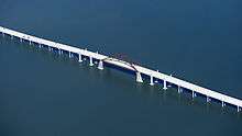
The Lewisville Lake Toll Bridge (LLTB) is a tied arch bridge crossing Lewisville Lake in Denton County, Texas, USA. The North Texas Tollway Authority (NTTA) worked cooperatively with Denton County to plan and design a toll bridge across the northwestern arm of Lewisville Lake. The new four-lane toll bridge connects Swisher Road in Lake Dallas to Eldorado Parkway in Little Elm, Texas. The Lewisville Lake Corridor is approximately 13.8 miles long and is divided into eight sections constructed by Denton County, NTTA, TxDOT, Little Elm, and Frisco, Texas.[2]
Motorists in these fast-growing areas of Denton County are now able to travel on a new connection between Interstate 35E and the Dallas North Tollway, eliminating the circuitous (and highly congested) routes currently required around Lewisville Lake (though it now funnels traffic onto I-35E north of the bridge over Lewisville Lake, which itself is a notorious bottleneck). The conceptual design of the project entailed eight sections that, together, total 13 miles (21 km). Only the 1.7-mile (2.7 km) bridge over the lake is tolled. The bridge is 55 feet (17 m) above the normal water level, to allow clearance for sailboats. The "signature" of the bridge, according to the NTTA, is the 360-foot (110 m) steel section with arches that rise to 60 feet (18 m) above the road deck (which resembles the arches of Austin's Pennybacker Bridge). The surfaces of this section are lighted with LEDs at night to make the structure visible from the surrounding shores of the lake.[3]
The project opened to vehicular traffic on August 1, 2009 after a charity run and walk across the bridge. The NTTA stated that occasion was the only time pedestrians will ever be allowed to cross the bridge. The NTTA funded and constructed the toll bridge while the cities along the corridor, Denton County and Texas Department of Transportation (TxDOT) funded improvements to the roadways approaching the bridge. The NTTA toll across the bridge section is $1.06 for TollTag customers and $1.59 for ZipCash drivers.[4]
History
A bridge previously connected Little Elm and Lake Dallas, but was removed in the 1950s when the United States Army Corps of Engineers expanded Lewisville Lake. The old bridge provided a vital transportation link between Lake Dallas and Little Elm.[5]
Project Costs
Key Dates
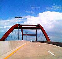
- May 2005 - The NTTA Board of Directors selected a preliminary design of the bridge, which features a distinctive tied arch spanning 360 feet (110 m) at the center with approaches and thresholds flanked by pairs of lighted columns.
- Late 2005 - A Finding of No Significant Impact (FONSI) for the Environmental Impact Assessment is received
- Early 2006 - Completion of plans, specifications and estimates on the toll bridge and public hearings for sections 4-6 and 8. Design for sections 4-6 initiated.
- Spring 2006 - Denton County broke ground on Section 1, west of the bridge, and construction is under way.
- Summer 2006 - Construction on Section 3, the eastern approach to the bridge, is planned to begin in late summer 2006.
- January 2007 - Groundbreaking for the bridge was held in Denton County on January 31, 2007
- May 2007 - Crews have built and placed many of the rebar frames for the support columns on the west bank and will soon begin pouring concrete into them.
- May 2008 - Construction of the bridge reached the halfway point.
- January 2009 - All four corner pieces of the arch structure are in place.
- April 2009 - The last major rib arch piece was installed. Construction is approximately 90% complete.
- August 1, 2009 - Charity run and walk across bridge. Bridge opens to vehicular traffic.[7]
- February 28, 2010 - Last portions of the construction work are completed, including work on the arch lighting.[8]
Map and Images
- Detailed Map (PDF): A detailed map of the whole project is available as a PDF from the Denton County Commissioner's page.
- High-resolution Rendering: A high resolution rendering of the bridge's "gateway" span is available from the Denton County Commissioner's page.
See also
References
- 1 2 3 4 5 6 7 8 9 ntta.org. "Lewisville Lake Toll Bridge to Open Aug. 1" (PDF). Archived from the original (PDF) on 2011-06-07. Retrieved 2009-08-02.
- ↑ ntta.org (2009-07-01). "Lewisville Lake Toll Bridge Progress Report" (PDF). Archived from the original (PDF) on 2011-06-07. Retrieved 2009-08-02.
- ↑ ntta.org (2007-01-01). "Bridging the Gap: NTTA to break ground on the Lewisville Lake Toll Bridge". Archived from the original on 2012-07-10. Retrieved 2009-08-02.
- ↑ dallasnews.com (2009-07-02). "Lewisville Lake Toll Bridge bringing some benefits already". Retrieved 2009-07-08.
- ↑ lakedallas.com. "Our Story". Archived from the original on 2009-06-06. Retrieved 2009-07-08.
- 1 2 ntta.org (2009-07-01). "Lewisville Lake Toll Bridge (LLTB)". Archived from the original on 2009-08-01. Retrieved 2009-08-02.
- ↑ dallasnews.com (2009-08-01). "Lewisville Lake Toll Bridge opens". Retrieved 2009-08-02.
- ↑ "Lewisville Lake Toll Bridge Progress Report March 2010" (PDF). North Texas Tollway Authority. March 2010. p. 1. Archived from the original (PDF) on 7 June 2011. Retrieved 25 March 2010.