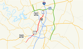
Texas State Highway Loop 1
| ||||
|---|---|---|---|---|
| MoPac Expressway | ||||
 | ||||
| Route information | ||||
| Length | 25.698 mi[1] (41.357 km) | |||
| Existed | 1967–present | |||
| Major junctions | ||||
| South end |
| |||
|
| ||||
| North end |
| |||
| Location | ||||
| Counties | Travis, Williamson | |||
| Highway system | ||||
| ||||


Loop 1 is a freeway which provides access to the west side of Austin in the U.S. state of Texas. It is named Mopac Expressway (or, according to some highway signs, Mopac Boulevard) after the Missouri Pacific Railroad (or "MoPac"). Local residents will invariably use the name "MoPac" rather than calling the road by its number[2][3] which can cause much confusion as few signs along the road use this name.[4][5] Adding to the confusion, the road goes in a mostly straight line rather than a loop.
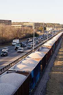
The original section of the highway was built in the 1970s along the right-of-way of the Missouri Pacific Railroad (now owned by Union Pacific), with the railroad tracks running in the highway median between West 8th Street and Northland Drive. To the north, the tracks run along the east side of newer sections of the highway from Northland Drive to Braker Lane.
History
Route designation

The first mention of Loop 1 came to public record in 1929. In 1944, the City of Austin Planning Commission (CMAC) proposed the highway be built in parts of under-utilized right of way owned by the MoPac railroad. Thus, the highway was eventually given the nickname "MoPac" for its proximity to the railroad. The number was originally used for Spur 1 designated on September 26, 1939 from US Highway 90 (US 90) to the Uvalde fish hatchery as a renumbering of SH 3 Spur. This route was cancelled on December 16, 1943. On March 26, 1958, a new route was designated, also called Spur 1, from US 80A to I-10. This route became part of Loop 16 on July 31, 1964, which itself got cancelled on June 26, 1974 when it was transferred to rerouted US 62 and US 85.[1] Loop 1 was first designated on October 27, 1967 from US 290 northward to Farm to Market Road 1325 (FM 1325). On October 24, 1985, the designation was extended southward from US 290 to SH 45.[1]
Expressway construction (1969 to 2006)
| From | To | Length (mi) |
Length (km) |
Year project began |
Year of project completion |
Notes |
|---|---|---|---|---|---|---|
| RM 2244 (Bee Cave Road) |
RM 2222 (Northland Road) |
5.4 | 8.7 | February 1969 | November 1975 | Loop 1 project started with construction of the 45th Street Interchange in February 1969. |
| RM 2222 | US 183 | 4.6 | 7.4 | September 1977 | June 1981 | Northern terminus of Loop 1 completed, until July 1989 - with construction of the freeway extension to FM 734. |
| RM 2244 | Loop 360 | 1.9 | 3.1 | January 1979 | March 1982 | Southern terminus of Loop 1 completed, until October 1989 - with construction of the freeway extension to US 290. |
| Loop 360 | US 290 | 1.6 | 2.6 | October 1983 | October 1989 | Southern terminus of Loop 1 completed, until November 1990 - with construction of the roadway extension to Slaughter Lane. |
| US 183 | FM 1325 (Burnet Road) and FM 734 (Parmer Lane) |
3.7 | 6.0 | January 1986 | July 1989 | Northern terminus of Loop 1 completed, until October 2006 - with construction of the SH 45 North/ Loop 1 Connector toll road. Stack interchange at US 183 is constructed - involved major freeway improvements between Steck Avenue and US 183, from March 1987 to June 1992. |
| US 290 | Slaughter Lane | 3.6 | 5.8 | January 1988 | November 1990 | Southern terminus of Loop 1 completed, until July 1991 - with construction of the roadway extension to La Crosse Avenue. |
| Slaughter Lane | La Crosse Avenue | 1.0 | 1.6 | July 1989 | July 1991 | Southern terminus of Loop 1 completed, until May 1994 - with construction of the roadway extension to State Highway 45 . |
| La Crosse Avenue | SH 45 | 2.5 | 4.0 | November 1989 | May 1994 | Southern terminus of Loop 1 completed. |
| FM 734 | SH 45 North/ Loop 1 Interchange |
4.0 | 6.4 | February 2003 | October 2006 | Construction on the SH 45 North Interchange began in September 2003. Northern terminus of Loop 1 completed. |
Route description
Loop 1's southern terminus is at the beginning of the State Highway 45 stub south of Austin. It passes through the Circle C Ranch housing development and the Edwards Aquifer and intersects SH 71/US 290 (Ben White Boulevard) and Loop 360 (Capital of Texas Highway). It crosses the Colorado River near downtown Austin; the view of the Texas State Capitol from the bridge became one of the Capitol View Corridors protected under state and local law from obstruction by tall buildings in 1983.[9] North of the river, the highway runs parallel to the Balcones Fault and the Missouri-Pacific Railroad before intersects US 183 (Research Boulevard) northwest of downtown. Loop 1 travels concurrently with Farm to Market Road 1325 for several miles before the non-tolled freeway ends at Parmer Lane, spanning a distance of 22.061 miles (35.504 km).
North of Parmer Lane, Loop 1 continues as a limited-access toll road to the SH 45 North/Loop 1 interchange, spanning 3 miles (4.8 km). Frontage roads flank either side of the toll road to Merrilltown Drive.
The Texas Department of Transportation completed construction of the tollway as part of the 2002 Central Texas Turnpike Project (CTTP). SH 45 North, also part of the project, provides freeway access to Interstate 35 from Loop 1. The 2002 CTTP was scheduled to be completed in September 2007. However, certain sections of the project, including Loop 1 opened early and more than $100 Million under budget.
If and when SH 45 is completed to the south of Austin, Loop 1 will effectively serve as a true loop to the west of the city, being directly connected to SH 45, and indirectly to I-35, at both ends.
MoPac Improvement Project
Since 1994, TxDOT has proposed the addition of managed lanes to portions of Loop 1. The MoPac Improvement Project[10] was relaunched in July 2010. In December 2010, four alternative proposals were presented to the public, each of which would add one or more lanes; the "no-build" alternative was also presented. The additions would not increase the right-of-way of the highway, but would be created by reducing the width of existing lanes and reducing and/or eliminating shoulders. An environmental study was completed in August 2012 with a Finding Of No Significant Impact and a recommendation of one new travel lane in each direction, operated as express lanes.[11] Construction began in 2013, and was originally scheduled for completion in September 2015, but by August 2016, the Central Texas Regional Mobility Authority announced further delays.[12] The first of four tolled sections, specifically the northbound toll lane from RM 2222 to Parmer Lane, opened on October 17, 2016. The remainder of the northbound express lane, from Cesar Chavez Street to Parmer Lane, opened on October 7th, 2017, and the entire southbound express lane opened on October 28th, 2017.
MoPac Intersections Project
In 2013, the Central Texas Regional Mobility Authority (CTRMA) and TxDOT initiated an environmental study to analyze the best options to improve the MoPac intersections at Slaughter Lane and La Crosse Avenue. In December 2015, the study was completed with a Finding Of No Significant Impact for the project, which allowed it to move forward.[13] The selected design includes replacing the at-grade intersection at Slaughter Lane with a diverging diamond interchange[14] and the at-grade intersection at La Crosse Avenue with a diamond interchange. The project broke ground in January 2018 with Webber, LLC as the general contractor. The DDI is expected to be complete by mid-January 2019, with total project completion expected in 2021.[15]
Exit list
All exits are unnumbered.
| County | Location | mi | km | Destinations | Notes |
|---|---|---|---|---|---|
| Travis | Austin | 0.0 | 0.0 | ||
| 0.7 | 1.1 | South Bay Lane | At-grade intersection; dead end both directions, turnaround only | ||
| 1.5 | 2.4 | La Crosse Avenue | At-grade intersection | ||
| 2.3 | 3.7 | Slaughter Lane | at-grade intersection; south end of freeway | ||
| 2.9 | 4.7 | Davis Lane | Southbound exit and northbound entrance | ||
| 4.7 | 7.6 | William Cannon Drive | |||
| 6.0 | 9.7 | ||||
| 6.6 | 10.6 | Frontage Road | Southbound exit only | ||
| 7.5 | 12.1 | Only one stack intersection travels from southbound Loop 1 to southbound Loop 360; all others are at-grade | |||
| 8.9 | 14.3 | Barton Skyway | |||
| 9.8 | 15.8 | ||||
| 10.5 | 16.9 | Cesar Chavez Street / 5th Street / Lake Austin Boulevard | South end of variable toll lanes | ||
| 11.2 | 18.0 | Enfield Road | |||
| 11.7 | 18.8 | Windsor Road | |||
| 12.3 | 19.8 | Westover Road / Northwood Road | |||
| 12.9 | 20.8 | Access to Seton Main Hospital | |||
| 13.8 | 22.2 | 45th Street | |||
| 14.8 | 23.8 | Access point for variable toll lanes | |||
| 15.9 | 25.6 | Far West Boulevard | |||
| 16.6 | 26.7 | Anderson Lane / Spicewood Springs Road | Direct northbound exit and southbound entrance (southbound exit signed at Steck Avenue) | ||
| 17.1 | 27.5 | Steck Avenue | No direct northbound entrance (signed at Capital of Texas Highway) | ||
| 17.3 | 27.8 | (no name) | Northbound exit only; replaced by northbound collector distributor road underneath Steck Avenue[16] | ||
| 18.0 | 29.0 | no direct southbound exit to US 183 north (signed at Capital of Texas Highway), access to Seton Northwest Hospital | |||
| 18.7 | 30.1 | Capital of Texas Highway | |||
| 19.1 | 30.7 | Braker Lane | no direct northbound exit (signed at Capital of Texas Highway) | ||
| 20.5 | 33.0 | South end of FM 1325 overlap, access to North Austin Medical Center | |||
| 21.7 | 34.9 | North end of variable toll lanes | |||
| 22.4 | 36.0 | Scofield Ridge Parkway | no direct southbound exit | ||
| 23.1 | 37.2 | ||||
| | 24.0 | 38.6 | Toll plaza | ||
| Travis–Williamson county line | 24.5 | 39.4 | Shoreline Drive | No southbound exit | |
| Williamson | 25.6 | 41.2 | |||
1.000 mi = 1.609 km; 1.000 km = 0.621 mi
| |||||
See also

References
- 1 2 3 Transportation Planning and Programming Division (n.d.). "State Highway Loop No. 1". Highway Designation Files. Texas Department of Transportation. Retrieved March 24, 2013.
- ↑ http://austin.about.com/od/gettingaroundaustin/a/StreetNames.htm
- ↑ http://news.travel.aol.com/2010/08/26/austin-slang/
- ↑ http://www.alwaysaustin.com/2011/04/deciphering-austin-street-names/?doing_wp_cron=1325493261
- ↑ http://www.yelp.com/topic/austin-mopac-expressway-just-wondering
- ↑ "Introduction: Mopac Improvement Project, April 2012" (PDF). Retrieved April 1, 2012.
- ↑ "The MoPac 1 Project will study feasibility of managed lanes for Loop 1, and included in the Mobility 2030 Plan that was adopted by CAMPO in June 2005". Archived from the original on February 23, 2006. Retrieved June 1, 2005.
- ↑ "What Native American tribe was most common in the area?". Texas Department of Transportation. Archived from the original on May 7, 2010. Retrieved January 24, 2010.
- ↑ "Downtown Development and Capitol View Corridors" (PDF). Downtown Austin Commission. June 27, 2007. Retrieved November 10, 2017.
- ↑ MoPac Improvement Project
- ↑ Ham, Justin. "Finding" (PDF). MoPac Improvement Project. U.S. Dept. of Transportation, Federal Highway Administration, Texas Division. Retrieved 5 September 2016.
- ↑ Jechow, Andy (August 25, 2016). "Weather, paving corrections push back North MoPac opening date". KXAN-TV. Retrieved 5 September 2016.
- ↑ "About MoPac Intersections". Retrieved 18 February 2018.
- ↑ "MoPac South: Diverging Diamond Interchange Simulation". Central Texas Regional Mobility Authority. April 16, 2015. Retrieved September 30, 2018.
- ↑ "MoPac Intersections". www.txdot.gov. Texas Department of Transportation. Retrieved 2018-09-27. Note: This source incorrectly refers to interchanges as intersections.
- ↑ "Mopac Improvement: Steck Avenue Collector-Distributor Lane Construction". Retrieved June 22, 2016.
- "Construction contract for Loop 1 extension awarded" (Press release). Texas Tollways. June 26, 2003.
- "Loop 1 History". Texas Department of Transportation. Archived from the original on 2010-05-07. Retrieved 2009-01-03.
- "Austin toll roads will open November 1" (PDF) (Press release). Central Texas Turnpike System. September 18, 2006. Archived from the original (PDF) on June 20, 2007.