Beattock Summit
| Beattock Summit | |
|---|---|
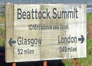 Sign marking the summit, as seen from the West Coast Main Line | |
| Location | |
| Place | Scotland |
| Area | South Lanarkshire |
| Coordinates | 55°25′18″N 3°35′27″W / 55.4217°N 3.5907°WCoordinates: 55°25′18″N 3°35′27″W / 55.4217°N 3.5907°W |
| Grid reference | NS994152 |
| Operations | |
| Original company | Caledonian Railway |
| Pre-grouping | Caledonian Railway |
| Post-grouping | London Midland and Scottish Railway |
| Platforms | 2 |
| History | |
| 3 January 1900 | Station opens[1] |
| After 1926 | Station close[1] |
| Disused railway stations in the United Kingdom | |
|
Closed railway stations in Britain A B C D–F G H–J K–L M–O P–R S T–V W–Z | |
|
| |
Beattock Summit is a high point of the West Coast Main Line (WCML) railway and of the A74(M) motorway as they cross between Dumfries and Galloway and South Lanarkshire in south west Scotland.
Railway history
The highest point on the WCML north of the border (built by the Caledonian Railway and opened on 15 February 1848), it is located 52 miles (83 km) south of Glasgow Central and 349 miles (558 km) north of London Euston stations. The height of the summit is 1,033 feet (315 m) above sea level. The signboard by the rail track records the elevation as 1,016 feet.
The summit was the location of a private halt from 1900 to around 1926.[1]
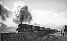
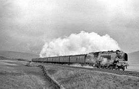
Steam locomotives frequently required banking assistance in getting their heavy trains up the incline, particularly in the northbound direction, which had steeper gradients. There was an engine shed at Beattock which had banking locomotives on standby twenty-four hours per day to minimise train delays.
The severity of the climb to the summit is referenced in W. H. Auden's poem Night Mail, written in 1936 for the G.P.O. Film Unit's celebrated production of the same name.
Electric locomotives, as far back as the Class 86, as well as today's Virgin Trains services, climb the gradient without assistance.
| Preceding station | Historical railways | Following station | ||
|---|---|---|---|---|
| Auchencastle Line open; Station closed |
Caledonian Railway Main Line |
Elvanfoot Line open; Station closed | ||
References
| Wikimedia Commons has media related to Beattock. |
Notes
Sources
- Butt, R. V. J. (1995). The Directory of Railway Stations: details every public and private passenger station, halt, platform and stopping place, past and present (1st ed.). Sparkford: Patrick Stephens Ltd. ISBN 978-1-85260-508-7. OCLC 60251199.
- Jowett, Alan (March 1989). Jowett's Railway Atlas of Great Britain and Ireland: From Pre-Grouping to the Present Day (1st ed.). Sparkford: Patrick Stephens Ltd. ISBN 978-1-85260-086-0. OCLC 22311137.
- Jowett, Alan (2000). Jowett's Nationalised Railway Atlas (1st ed.). Penryn, Cornwall: Atlantic Transport Publishers. ISBN 978-0-906899-99-1. OCLC 228266687.
- Nock, O.S. (1974). Electric Euston to Glasgow (1st ed.). London: Ian Allan Limited. ISBN 0-7110-0530-3. OCLC 2283378.
- RAILSCOT on Caledonian Railway
- Beattock Summit on navigable OS map
- British Transport Films, (1974). "Wires over the Border". Disc One, Track 5, In: British Transport Films Collection. Volume 3: Running a Railway. (DVD Format), BFIVD720.