Bearskin Lake Airport
| Bearskin Lake Airport | |||||||||||
|---|---|---|---|---|---|---|---|---|---|---|---|
 | |||||||||||
| Summary | |||||||||||
| Airport type | Public | ||||||||||
| Operator | Government of Ontario | ||||||||||
| Location | Bearskin Lake, Ontario | ||||||||||
| Time zone | CST (UTC−06:00) | ||||||||||
| • Summer (DST) | CDT (UTC−05:00) | ||||||||||
| Elevation AMSL | 800 ft / 244 m | ||||||||||
| Coordinates | 53°57′56″N 091°01′38″W / 53.96556°N 91.02722°WCoordinates: 53°57′56″N 091°01′38″W / 53.96556°N 91.02722°W | ||||||||||
| Map | |||||||||||
 CNE3 Location in Ontario | |||||||||||
| Runways | |||||||||||
| |||||||||||
|
Source: Canada Flight Supplement[1] | |||||||||||
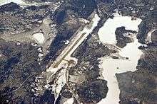
Bearskin Lake Airport, (IATA: XBE, TC LID: CNE3), is located 3 nautical miles (5.6 km; 3.5 mi) northwest of Bearskin Lake, Ontario, Canada. It is serviced with regular scheduled flights by Wasaya Airways.
References
- ↑ Canada Flight Supplement. Effective 0901Z 19 July 2018 to 0901Z 13 September 2018.
External links
- Page about this airport on COPA's Places to Fly airport directory
- Accident history for XBE at Aviation Safety Network
| By name | |
|---|---|
| By location indicator | |
| By province/territory | |
| By area | |
| National Airports System | |
| Related | |
| |
This article is issued from
Wikipedia.
The text is licensed under Creative Commons - Attribution - Sharealike.
Additional terms may apply for the media files.