La Paz, Baja California Sur
| La Paz | |||
|---|---|---|---|
| City | |||
 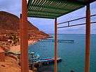   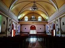  From up to down and left to right: Cathedral of La Paz, El Coromuel Water Park, Cathedral of our lady of La Paz, Stone in Playa Balandra, Inside the Cathedral of La Paz and Playa Balandra | |||
| |||
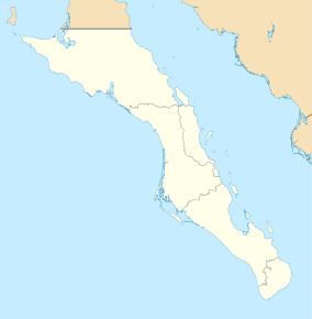 La Paz Location of La Paz in Baja California Sur | |||
| Coordinates: 24°08′32″N 110°18′39″W / 24.14222°N 110.31083°WCoordinates: 24°08′32″N 110°18′39″W / 24.14222°N 110.31083°W | |||
| Country | Mexico | ||
| State | Baja California Sur | ||
| Municipality | La Paz | ||
| Founded | May 3, 1535 | ||
| named La Paz | 1596 | ||
| Government | |||
| • Municipal president | Lic. Armando Martinez Vega (PAN) | ||
| Elevation | 27 m (89 ft) | ||
| Population (2015 [1]) | |||
| • City | 244,219 [1] | ||
| • Metro | 290,286 [1] | ||
| Data source: INEGI | |||
| Time zone | UTC−7 (MST) | ||
| • Summer (DST) | UTC−6 (MDT) | ||
| Website | www.lapaz.gob.mx | ||
| Source: Enciclopedia de los Municipios de México | |||


La Paz (pronounced [la ˈpas] (![]()
The population of La Paz has grown greatly since the 2000s. The growth is largely because the city has one of the highest standards of living and quality of life in Mexico. Many workers migrate to La Paz and other areas in Baja California Sur.
La Paz is served by the Manuel Márquez de León International Airport with flights to the most important cities of Mexico: Mexico City, Guadalajara, Monterrey. Airlines flying into La Paz include Aeroméxico Connect, Volaris and VivaAerobus. Two ferry services operate from the port of Pichilingue outside the city, connecting the Baja California peninsula to the mainland at Mazatlán and Topolobampo, near Los Mochis.
History
La Paz was first inhabited by Neolithic hunter-gatherers at least 10,000 years ago who left traces of their existence in the form of rock paintings near the city and throughout the Baja California Peninsula. Fortun Ximenez piloted the Concepcion into the bay in late 1533. He and twenty-two of his crew were killed by the native population.[3] On May 3, 1535, Hernán Cortés arrived in the bay by La Paz and named it "Santa Cruz"; he attempted to start a colony but abandoned his efforts after several years due to logistical problems.[4] In 1596 Sebastián Vizcaíno arrived, giving the area its modern name, La Paz.
From January 10, 1854 to May 8, 1854 it served as the capital of William Walker's Republic of Sonora. The project collapsed due to lack of US support and pressure from the Mexican government to retake the region.
Climate

La Paz has a desert climate. The climate of La Paz is relatively consistent with generally little rainfall, with a year around average temperature of between 17 and 30 °C (63 and 86 °F). Summer months (July–September) typically see highs between 34 and 36 °C (93 and 97 °F) and dew points of 21–23 °C (70–73 °F).[5] The winter months (December–February) are the coldest with temperatures dropping below 15 °C (59 °F) at night, but mostly maxima are from 20 to 25 °C (68 to 77 °F). Breezes from Bahía de La Paz moderate the temperature. The bay also acts as a barrier against seasonal storms in the Gulf of California.
Rainfall is minimal at most times of year, although erratic downpours can bring heavy rains. Rain tends to be concentrated in a short, slightly rainier season that peaks in August and September, following the pattern of the North American Monsoon. The driest season, where it is common to have no rain, occurs March through June. La Paz averages over 300 days of sunshine annually and an average of 3148 sunshine hours.
During the summer the cooling Coromuel winds, a weather phenomenon unique to the La Paz area, blow during the night from the Pacific over the Peninsula and into the Bay of La Paz.
As with most of the Gulf of California, the temperature of the water changes substantially over the course of the year, with temperatures around 68 °F (20 °C) during winter and around 85 °F (29 °C) during summer.[6][7][8][9]
| Climate data for La Paz (1951–2010) | |||||||||||||
|---|---|---|---|---|---|---|---|---|---|---|---|---|---|
| Month | Jan | Feb | Mar | Apr | May | Jun | Jul | Aug | Sep | Oct | Nov | Dec | Year |
| Record high °C (°F) | 35.2 (95.4) |
37.4 (99.3) |
38.2 (100.8) |
41.0 (105.8) |
41.0 (105.8) |
43.0 (109.4) |
43.0 (109.4) |
43.0 (109.4) |
43.0 (109.4) |
43.5 (110.3) |
38.5 (101.3) |
36.0 (96.8) |
43.5 (110.3) |
| Average high °C (°F) | 23.6 (74.5) |
24.9 (76.8) |
27.3 (81.1) |
30.3 (86.5) |
33.4 (92.1) |
35.6 (96.1) |
36.6 (97.9) |
36.2 (97.2) |
35.0 (95) |
32.6 (90.7) |
28.3 (82.9) |
24.4 (75.9) |
30.7 (87.3) |
| Daily mean °C (°F) | 17.4 (63.3) |
18.1 (64.6) |
19.7 (67.5) |
22.1 (71.8) |
24.5 (76.1) |
27.1 (80.8) |
29.7 (85.5) |
30.2 (86.4) |
29.3 (84.7) |
26.2 (79.2) |
22.0 (71.6) |
18.6 (65.5) |
23.7 (74.7) |
| Average low °C (°F) | 11.2 (52.2) |
11.3 (52.3) |
12.1 (53.8) |
13.9 (57) |
15.7 (60.3) |
18.6 (65.5) |
22.9 (73.2) |
24.1 (75.4) |
23.5 (74.3) |
19.9 (67.8) |
15.7 (60.3) |
12.8 (55) |
16.8 (62.2) |
| Record low °C (°F) | 2.0 (35.6) |
2.5 (36.5) |
3.0 (37.4) |
4.5 (40.1) |
8.5 (47.3) |
10.0 (50) |
11.5 (52.7) |
13.0 (55.4) |
12.0 (53.6) |
10.0 (50) |
6.5 (43.7) |
2.0 (35.6) |
2.0 (35.6) |
| Average rainfall mm (inches) | 14.2 (0.559) |
5.3 (0.209) |
2.3 (0.091) |
0.8 (0.031) |
0.9 (0.035) |
1.3 (0.051) |
14.5 (0.571) |
37.2 (1.465) |
58.4 (2.299) |
12.1 (0.476) |
7.4 (0.291) |
14.8 (0.583) |
169.2 (6.661) |
| Average rainy days (≥ 0.1 mm) | 1.8 | 1.1 | 0.4 | 0.2 | 0.1 | 0.2 | 2.1 | 4.1 | 4.1 | 1.5 | 0.8 | 1.8 | 18.2 |
| Average relative humidity (%) | 66 | 60 | 58 | 55 | 55 | 54 | 58 | 61 | 63 | 63 | 64 | 66 | 60 |
| Mean monthly sunshine hours | 200 | 234 | 271 | 292 | 332 | 322 | 287 | 258 | 257 | 272 | 233 | 190 | 3,148 |
| Source #1: Servicio Meteorológico Nacional (humidity 1981–2000)[10][11][12] | |||||||||||||
| Source #2: Deutscher Wetterdienst (sun, 1961–1990)[13][lower-alpha 1] | |||||||||||||
| Jan | Feb | Mar | Apr | May | Jun | Jul | Aug | Sep | Oct | Nov | Dec |
|---|---|---|---|---|---|---|---|---|---|---|---|
| 68 °F 20 °C |
66 °F 19 °C |
68 °F 20 °C |
72 °F 22 °C |
75 °F 24 °C |
79 °F 26 °C |
82 °F 28 °C |
84 °F 29 °C |
86 °F 30 °C |
84 °F 29 °C |
79 °F 26 °C |
72 °F 22 °C |
Economy
The population of La Paz has grown greatly since the 2000s.
Eco-tourism is by far the most important source of tourism income in La Paz. Tourists also visit the city's balnearios. There are some 900 islands and inlets in the Gulf of California with 244 now under UNESCO protection as World Heritage Bio-Reserves and the Isla Espíritu Santo group, which borders the northeast portion of the Bay of La Paz, the primary tourist destination of the area.
Industries include silver mining, agriculture, fishing and pearls. Tourism is also an important source of employment for this coastal community.
Along with the area's marinas, new developments are emerging because of the proximity to the United States.
When Aero California existed, its headquarters were in La Paz.[14]
Transportation

La Paz is served by Manuel Márquez de León International Airport with flights to the most important cities of Mexico: Mexico City, Guadalajara, Monterrey. Airlines flying into La Paz include Aeroméxico Connect, Volaris and VivaAerobus. Two ferry services operate from the port of Pichilingue outside the city, connecting the Baja California peninsula to the mainland at Mazatlán and Topolobampo, near Los Mochis.
Roads
Running along the coast in front of La Paz is 5 km (3.1 mi) long Malecon Road. The main purpose of this road is to allow easy movement across the city. However, it quickly became the focal point of tourist related activities with a large number of bars, restaurants and shops opening along its length. Since 2004 extensive development has taken place which included a large sidewalk which offers safety for large numbers of people to walk along the coastal front of La Paz.
In September 2011, a bicycle lane was added to Malecon Road, providing cyclists protection from cars and pedestrians.
La Paz is served mainly by two highways; Mexican Federal Highway 1 that links the south of the state from Cabo San Lucas to the north of the peninsula to Tijuana, and Mexican Federal Highway 19, that connects La Paz with the population of the south pacific towns such as Todos Santos and El Pescadero. It is also served by two secondary roads, the Los Planes highway (286) that connects La Paz with towns such as La Ventana, Ensenada de los Muertos and Los Planes. The other is the Pichilingue highway which links La Paz with its maritime port.
Demographics
The city had a 2015 census population of 244,219 inhabitants,[1] making it the most populous city in the state. Its metropolitan population is somewhat larger because of the surrounding towns, such as El Centenario, Chametla and San Pedro. Its surrounding municipality, which is the fourth-largest municipality in Mexico in geographical size, reported a population of 290,286 inhabitants.
| Historical population | ||
|---|---|---|
| Year | Pop. | ±% |
| 1960 | 24,253 | — |
| 1970 | — | |
| 1980 | — | |
| 1990 | 136,759 | — |
| 1995 | 154,314 | +12.8% |
| 2000 | 162,954 | +5.6% |
| 2005 | 189,178 | +16.1% |
| 2010 | 215,178 | +13.7% |
| 2015 | 244,219 | +13.5% |
| Sources:[15][16] | ||
Education
La Paz is the state capital and center of commerce, as well as the home of the three leading marine biology institutes in Latin America (UABCS, CIBNOR & CICIMAR), largely because it sits on the Gulf of California, which is home to exceptional marine biodiversity. It also supports several other university-level institutes of learning, such as the Universidad Autonoma de Baja California Sur.
Popular culture
John Steinbeck visited La Paz in 1940. He describes the town in his 1947 novel The Pearl and mentions it extensively in his 1951 travelogue The Log from the Sea of Cortez.[17]
The city is also the setting of the 1967 Scott O'Dell children's novel The Black Pearl, chosen as a Newbery Honor Book in 1968.,[18] where La Paz is the home of the main character.
Sister cities


See also
Notes
- ↑ Station ID for La Paz, BCS is 76405 Use this station ID to locate the sunshine duration
References
- 1 2 3 4 5 "Data" (PDF). www.saludbcs.gob.mx.
- ↑ (in Spanish) Los Municipios con Mayor y Menor Extensión Territorial Archived 2007-03-03 at the Wayback Machine., Instituto Nacional Para el Federalismo y el Desarrollo Municipal, SEGOB (Mexico.) Accessed 15 February 2008.
- ↑ P.38 footnote 12 "The Land of Sunshine Vol. 11 No. 1"
- ↑ Chapter 2, vol. 1, History of California, Theodore Henry Hittell, San Francisco: N. J. Stone & Company, 1897.
- ↑ "La Paz, Baja California Sur Travel Weather Averages". Retrieved 16 June 2017.
- ↑ "The Gulf of California - A Physical, Geological and Biological Study" By Rebekah K. Nix
- ↑ "Archived copy". Archived from the original on 2011-12-21. Retrieved 2012-06-12.
- ↑ http://redalyc.uaemex.mx/redalyc/html/479/47942204/47942204.html%5Bpermanent+dead+link%5D
- ↑ Ltd, Copyright Global Sea Temperatures - A-Connect. "La Paz Sea Temperature January Average, Mexico - Sea Temperatures". World Sea Temperatures. Retrieved 22 March 2018.
- ↑ "NORMALES CLIMATOLÓGICAS 1951-2010". Servicio Meteorológico Nacional. 2012. Retrieved 1 March 2017.
- ↑ "Extreme Temperatures and Precipitation for La Paz (DGE) 1940-2010" (in Spanish). Servicio Meteorológico Nacional. Retrieved 6 May 2015.
- ↑ "NORMALES CLIMATOLÓGICAS 1981–2000" (PDF) (in Spanish). Servicio Meteorológico Nacional. Archived from the original (PDF) on 25 April 2015. Retrieved 6 May 2015.
- ↑ "Station 76405 La Paz, BCS". Global station data 1961–1990—Sunshine Duration. Deutscher Wetterdienst. Retrieved 3 May 2015.
- ↑ "Directory: World Airlines". Flight International. 2007-03-27. p. 46.
- ↑ "MEXICO: Baja California Sur". Citypopulation.de. 2012-01-08. Retrieved June 1, 2012.
- ↑ "Archived copy". Archived from the original on 2014-09-15. Retrieved 2014-09-15.
- ↑ Steinbeck, John (2000). The Log from the Sea of Cortez. London: Penguin. pp. 84–105. ISBN 978-0-14-118607-8.
- ↑ Newbery Medal and Honor Books, 1922-Present Archived 2008-02-18 at the Wayback Machine., ALSC, American Library Association. Accessed on line 15-II-2008.
External links
| Wikimedia Commons has media related to La Paz, Baja California Sur. |
| Wikivoyage has a travel guide for La Paz (Mexico). |
La Paz (capital) | ||
| Municipalities and municipal seats |  | |
| ||