Bartram's Covered Bridge
|
Bartram's Covered Bridge | |
 Bartram's Covered Bridge | |
  | |
| Location | West of Newtown on Legislative Route 15098, Newtown, Pennsylvania |
|---|---|
| Coordinates | 39°59′23″N 75°26′15″W / 39.98972°N 75.43750°WCoordinates: 39°59′23″N 75°26′15″W / 39.98972°N 75.43750°W |
| Area | less than one acre |
| Built | 1860 |
| Built by | Wood, Ferdinand |
| Architectural style | Other, Burr truss |
| MPS | Covered Bridges of Chester County TR |
| NRHP reference # | 80003462[1] |
| Added to NRHP | December 10, 1980 |
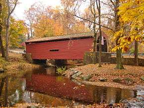
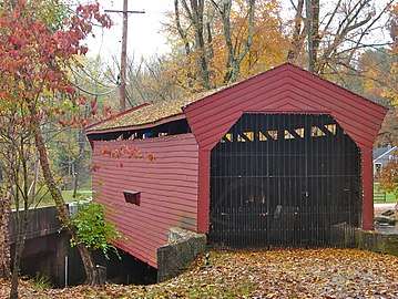
Bartram's Covered Bridge, a historic covered bridge built in 1860, uses a Burr Truss design and carried Goshen Road over Crum Creek on the border between Delaware County and Chester County, Pennsylvania. It is 30 feet (9.1 m) long and 13 feet (4.0 m) wide and is the only covered bridge remaining of the 30 which once stood in Delaware County. The bridge has slanted planks at each entrance and is the only covered bridge in Pennsylvania with this feature. According to an on-site marker from the Newtown Square Historical Preservation Society, the bridge was built to be "hi and wide as a load of hay"[2] It was built by Ferdinand Wood and named for Mordecai Bartram.[3]
It was closed to traffic in 1941 and stands next to a new bridge on Goshen Road. The east end of the bridge is located in Newtown Township, Delaware County and the west end in Willistown Township, Chester County.[4][5]
It was listed on the National Register of Historic Places in 1980.
%2C_Newtown_Square%2C_Delaware_County%2C_PA_HABS_PA%2C15-WHIHO.V%2C3-1.jpg)

%2C_Newtown_Square%2C_Delaware_County%2C_PA_HABS_PA%2C15-WHIHO.V%2C3-3.jpg)
See also
| Wikimedia Commons has media related to Bartram's Covered Bridge. |
References
- ↑ National Park Service (2010-07-09). "National Register Information System". National Register of Historic Places. National Park Service.
- ↑ Bartram's Covered Bridge, On the Newtown Square Historical Society's website.
- ↑ See Driscoll (2011), Introduction
- ↑ Zacher, Susan M. (1994). The Covered Bridges of Pennsylvania: A Guide. Harrisburg: Pennsylvania Historical and Museum Commission. p. 134.
- ↑ "National Historic Landmarks & National Register of Historic Places in Pennsylvania" (Searchable database). CRGIS: Cultural Resources Geographic Information System. Note: This includes Susan M. Zacher (July 1980). "National Register of Historic Places Inventory Nomination Form: Covered Bridges of Chester County TR, Bartram's Covered Bridge" (PDF). Retrieved 2012-01-02.
Sources
- Driscoll, Christopher P.; Conn, George D.; Humes, Doug P.; Gerst, Eric D. (2011). Bartram Covered Bridge: Spanning History. eBookIt.com and The Newtown Square Historical Preservation Society. p. 118.
| Topics |   | |
|---|---|---|
| Lists by county |
| |
| Lists by city | ||
| Other lists | ||
| ||