Barony of Kells
| Barony of Kells Ceanannas (Irish)[1] | |
|---|---|
| Barony | |
|
| |
| Etymology: head fort, seat or residence | |
 Barony of Kells Location in Ireland | |
| Coordinates: 52°27′47″N 7°19′43″W / 52.46306°N 7.32861°WCoordinates: 52°27′47″N 7°19′43″W / 52.46306°N 7.32861°W | |
| Country | Ireland |
| Province | Leinster |
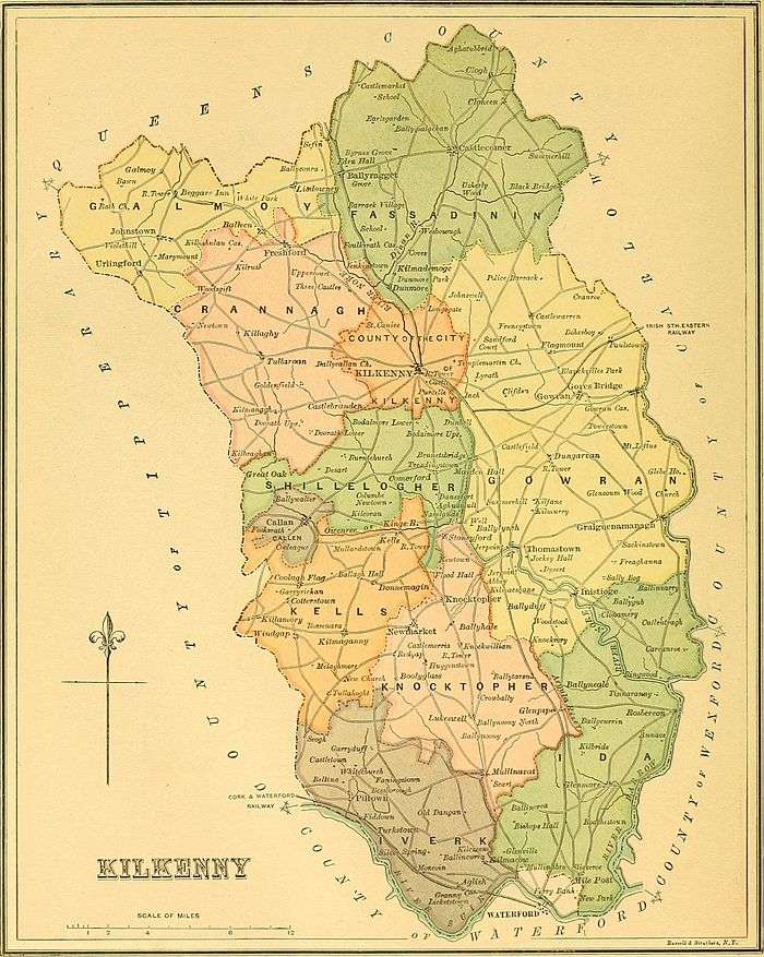
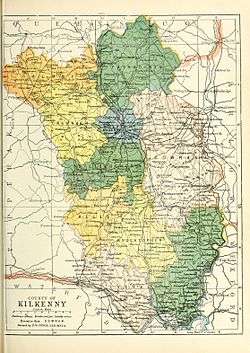
| County | County Kilkenny |
| Civil parishes | |
| Area[16] | |
| • Total | 15,530 ha (38,376 acres) |
Barony of Kells (Irish: Ceanannas, meaning "head fort, seat or residence") is a barony of 38,376 acres (15,530 ha) in the south west of County Kilkenny, Ireland.[17][1][18] Kells barony contains the towns of Kells and Kilmaganny.
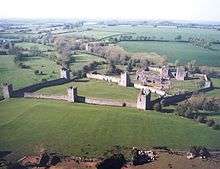
Part of the territory of the Ua Glóiairn of Callann,[19][20] and in the historic kingdom of Osraige (Ossory). Kells Priory is located in the barony.
Etymology
The name "Kells" developed from the ancient Irish: Ceanannas (pronounced Kannanas, accent on the first syllable). Still today Ceanannas is used by Irish speakers.[5] After the Norman Invasion "Ceanannas" was corrupted into "Kenelis", and later into "Kells". From the 12th century onward, the settlement was referred to in English and Anglo-Norman as Kenelis, Kenles, Kenlis, Kenlys, Kenllis, Cellys (Deanery), Kyllis, and it has been Kells since the 1655.
Carrigan 1905 says that there is no mention of Kells in Ossory in Gaelic records,[5] but agrees with John O'Donovan who suggests the name signifies "the head seat or residence".[21] And that this is of similar origin to Kells in County Meath.[5]
History
The barony of Kells is located in the historic Gaelic kingdom of Ossory (Osraige). According to O'Heerin's Topographical Poem (1420)[20] in the 1170s at the time of the Norman invasion the area was the territory of the clan called the Ua Glóiairn of Callann.[19][20] The "cantred of O'Glóiairn" was located on both sides of the river Callann, now the King's River[20] and included the present day barony of Callan. The territory of Callan was part of the early "cantred of Kells".
A cantred of a sweet country,
A smooth land along the beauteous Callainn,
A land without a particle of blemish."
In 1358 the "Barony of Kenlys" was very small and located in the eastern portion of the present barony.[22] In the western part of the modern barony was the "cantred of Erley".[22] The barony of Erley and the barony of Kells have been merged for many centuries.[22] The barony of Erley must also have included the parish of Earlstown or Erley that is now in the barony of Shillelogher, and the townland of Frankford also belonged to Erley.[22]
On the 14 January 1387 William, son of Richard Tobin ("de Sancto Albino") granted to James Butler, 2nd Earl of Ormond, one messuage, with two carucates, and 20 acres of arable land in Moyclere in the Barony of Erley.[23]
Baron of Kells, Geoffrey FitzRobert de Monte Marisco, who was Richard de Clare's Constable of Leinster, built a castle by the banks of the Kings River and founded a town (the village of Kells) in c.1192.[24] He married the illegitimate half-sister of Isabel de Clare, Basile de Clare, who was the widow of Raymond FitzGerald and grand-daughter to Gilbert de Clare. In the late 12th century, Huolyn (Howlin) served as Lords of Kilree.[25]
By the end of the 14th century the Sweetmans had succeeded the D'Erleys in their property of Earlstown and title Baron of Erley, they were based at Castleeve Castle.[22] Kells was recorded in the Down Survey (1656),[26] the 1840 Ordnance Survey map,[27] and on Griffith's Valuation (1864).[28]
Geography
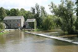
Contains the King's River or River Glory, which had a ford at Aughatarry and a bridge called Kyleadohir Bridge.[29][30][31] The King’s River originates in the Slieveardagh Hills, it flows 25 kilometres northwest to Kells village and it then flows 6 kilometres east where it feeds into the River Nore. The surrounding landscape is undulating, with a mix of tillage and grazing lands.[24] The Walsh Mountains are in the barony and they stretch into the barony of barony of Knocktopher.[32]
Kells barony contains the towns of Kells and Kilmaganny, and the settlements of Baurscoob, Windgap, Dunnamaggan.[33] The village of Kells is situated on the south side of the King’s River on its floodplain.[24]
Kells contais the civil parishes of Ballytobin, Coolaghmore, Dunnamaggan, Kells, Killamery, Kilmaganny, Kilree, Mallardstown, Stonecarthy, and Tullahought.[34]
Kells contains parts of the Roman Catholic parishes of Callan, Dunnamaggan, and Windgap.[35][21][36] Parts of the barony were in the Poor law unions of Callan, Carrick on Suir, and Thomastown.[16]
References
Footnotes
- 1 2 (Government 2003)
- ↑ (Carrigan 1905, pp. 34, Ballytobin)
- ↑ (Carrigan 1905, pp. 1,34, Vol IV: Roman Catholic Parish of Dunnamaggan)
- ↑ (Lewis 1837, p. 35, Kells civil parish)
- 1 2 3 4 (Carrigan 1905, pp. 371, Vol III: Kells; Carrigan 1905, pp. 34, Vol IV: Kells)
- ↑ (Lewis 1837, p. 223, Killamery civil parish)
- ↑ (Carrigan 1905, pp. 479, Vol III: Killamery; Carrigan 1905, pp. 331, Vol IV: Killamery)
- ↑ (Lewis 1837, p. 180, Kilmaganny civil parish)
- ↑ (Carrigan 1905, pp. 1,34,311, Vol IV: Kilmaganny)
- ↑ (Lewis 1837, p. 201, Kilree civil parish)
- ↑ (Carrigan 1905, pp. 34, Vol IV: Kilree)
- ↑ (Lewis 1837, p. 338, Mallardstown civil parish)
- ↑ (Carrigan 1905, pp. 290,323, Mallardstown)
- ↑ (Carrigan 1905, pp. 1, Vol I: Stonecarthy)
- ↑ (Carrigan 1905, pp. 311, Vol IV: Tullahought)
- 1 2 (Parliament 1862, p. 963, Kells Barony)
- ↑ (Fiontar 2008, Ceanannas/Kells)
- ↑ (Tighe 1802, p. 4, Baronies)
- 1 2 Walsh, Dennis. "Barony of Kells". ancestry.com.
- 1 2 3 4 5 (O'Huidhrin 1851, p. 8, PDF)
- 1 2 (Carrigan 1905, pp. 34-87, Vol IV: Religious Parish of Dunnamaggan)
- 1 2 3 4 5 6 (Carrigan 1905, p. 25, Existing Civil Divisions or Baronies)
- ↑ Grave's MSS.
- 1 2 3 (Kilkenny County Council 2005)
- ↑ Walsh, Dennis. "The Baronies of Ireland". ancestry.com. and Walsh, Dennis. "Barony Map of the Leinster Region". ancestry.com.
- ↑ Down Survey Project. "Kells Map". downsurvey.tcd.ie. The Down Survey Project.
- ↑ (Ordnance Survey Ireland 2016, Online Map) Historic Ordnance Survey Map, Survayed 1839 and published 1842. Sheets (KK023, KK026, KK027, KK030, KK031, KK034, and KK035)
- ↑ (Griffith 1864, Kells Search)
- ↑ (Fiontar 2008, River Glory)
- ↑ (Fiontar 2008, Aughatarry)
- ↑ (Fiontar 2008, Kyleadohir Bridge)
- ↑ (Fiontar 2008, Walsh Mountains)
- ↑ (Fiontar 2008, Kells Towns and Fiontar 2008, Kells population centres)
- ↑ (Fiontar 2008, Kells Civil Parishes)
- ↑ (Carrigan 1905, pp. 290-352, Vol III: Religious Parish of Callan)
- ↑ (Carrigan 1905, pp. 311-330, Vol IV: Religious Parish of Windgap)
Sources
- Carrigan, William (1905). The History and Antiquities of the Diocese of Ossory. Middle Abbey Street, Dublin: Sealy, Bryers & Walker. ISBN 9785879206463.
- Fiontar (2008). "Placenames Database of Ireland". logainm.ie. Department of Arts, Heritage, Regional Rural and Gaeltacht Affairs of the Government of Ireland.
- Government (2003). Placenames (Co. Kilkenny) Order 2003 (PDF). Dublin: Government of Ireland.
- Griffith, Richard (1864). "Griffith's Valuation". www.askaboutireland.ie.
- Kilkenny County Council (2005). "Kells Local Area Plan 2005" (PDF). kilkennycoco.ie.
- Lewis, Samuel (1837). A Topographical Dictionary of Ireland. Lewis.
- O'Huidhrin, Giolla Na Naomh (1851). O'Donovan, John, ed. The tribes and territories of ancient Ossory; comprising the portions of O'Heerin's and O'Dugan's topographical poems which relate to the families of that district. Dublin: J. O'Daly. ISBN 978-1143947490.
- Parliament (1862). General alphabetical index to townlands and towns, parishes and baronies of Ireland.
- Tighe, William (1802). Statistical observations relative to the county of Kilkenny: made in the years 1800 & 1801. Printed by Graisberry and Campbell.
- Ordnance Survey Ireland (2016). "Ordnance Survey, first edition (6 inch)". osi.ie.
External links
- Walsh, Dennis. "Barony of Kells". ancestry.com.
- Walsh, Dennis. "The Baronies of Ireland". ancestry.com.
- Walsh, Dennis. "Barony Map of the Leinster Region". ancestry.com.
Places adjacent to Barony of Kells | ||||||||||
|---|---|---|---|---|---|---|---|---|---|---|
| ||||||||||
|  | |
| ||