Barony of Gowran
| Gowran Gabhrán (Irish) | |
|---|---|
| Barony | |
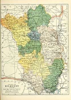 Baronies of County Kilkenny. | |
| Sovereign state | Republic of Ireland |
| County | Kilkenny |
Barony of Gowran (Irish: Gabhrán[1][2]) is a barony in the east of County Kilkenny, Ireland.[3]
Geography
Gowran contains the towns of Thomastown, Paulstown, Bennettsbridge, Goresbridge, Gowran, Graiguenamanagh, and Inistioge, and the settlements of Ballyfoyle, Maddockstown, Paulstown, Whitehall, Castlewarren, Dungarvan, Rathgarvan or Clifden, Skeaghvasteen, and Johnswell.[4]
Gowran contains the civil parishes of Blackrath, Blanchvilleskill, Clara, Columbkille, Dunbell, Dungarvan, Famma, Gowran, Graiguenamanagh, Grangesilvia,Inistioge, Jerpointabbey, Jerpointwest, Kilderry,Kilfane, Kilkieran, Killarney, Kilmacahill,Kilmadum, Mothell, Pleberstown, Powerstown, Rathcoole, Shankill, St. John's, St. Martin's, St. Maul's, Thomastown, Tiscoffin, Treadingstown, Tullaherin, Ullard, Wells, and Woolengrange.[5]
History
Gowran was recorded in the Down Survey (1656),[6] and on Griffith's Valuation (1864).[7] Parts of the barony were in the Poor law unions of Castlecomer, Kilkenny, and Thomastown.[8]
Territory of O'Carroll and O'Dunphy.[9] Given to Theobald Fitzwalter (Butler ).[9] Dobbyn family based there in the 15th century.[9]
Contains the ecclesiastical sites of Kilfane and Duiske Abbey.[10]
Woodstock Castle is in Gowran.[11]
Notes
- ↑ (Fiontar 2008, Gabhrán/Gowran)
- ↑ (Carrigan 1905, p. 24, Existing Civil Divisions or Baronies)
- ↑ (Tighe 1802, p. 4, Baronies)
- ↑ (Fiontar 2008, Gowran Towns and Fiontar 2008, Gowran population centres)
- ↑ (Fiontar 2008, Gowran Civil Parishes)
- ↑ Down Survey Project. "Gowran Map". downsurvey.tcd.ie. The Down Survey Project.
- ↑ (Griffith 1864, Gowran Search)
- ↑ (Parliament 1862, p. 963, Gowran Barony)
- 1 2 3 Walsh, Dennis. "The Baronies of Ireland". ancestry.com. and Walsh, Dennis. "Barony Map of the Leinster Region". ancestry.com.
- ↑ (Fiontar 2008, Gowran ecclesiastical sites)
- ↑ (Fiontar 2008, Woodstock Castle)
References
- Fiontar (2008). "Placenames Database of Ireland". logainm.ie. Department of Community, Rural and Gaeltacht Affairs of the Government of Ireland.
- Griffith (1864). "Griffith's Valuation". www.askaboutireland.ie.
- Parliament (1862). General alphabetical index to townlands and towns, parishes and baronies of Ireland.
- Carrigan, William (1905). The History and Antiquities of the Diocese of Ossory. Sealy, Bryers & Walker. ISBN 9785879206463.
- Tighe, William (1802). Statistical observations relative to the county of Kilkenny: made in the years 1800 & 1801. Printed by Graisberry and Campbell.
External links
- Fiontar (2008). "Placenames Database of Ireland". logainm.ie. Department of Community, Rural and Gaeltacht Affairs of the Government of Ireland.
- Walsh, Dennis. "The Baronies of Ireland". ancestry.com.
- Walsh, Dennis. "Barony Map of the Leinster Region". ancestry.com.
| | |
| ||