Barony of Iverk
| Iverk[1] Uíbh Eirc (Irish) | |
|---|---|
| Barony | |
|
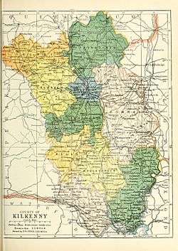
Map of Iverk | |
 Iverk[1] Location in Ireland | |
| Coordinates: 52°18′54″N 7°16′26″W / 52.315°N 7.274°WCoordinates: 52°18′54″N 7°16′26″W / 52.315°N 7.274°W | |
| Country | Ireland |
| Province | Leinster |
| County | County Kilkenny |
| Civil parishes |
List
|
| Area[2] | |
| • Total | 16,741 ha (41,368 acres) |
Barony of Iverk (Irish: Uíbh Eirc[3][4]) is a barony in the south west of County Kilkenny, Ireland.[5] The size of the barony is 41,368 acres (167.41 km2).[2] Iverk was part of the historic Gaelic kingdom of Ossory (Osraige).
History
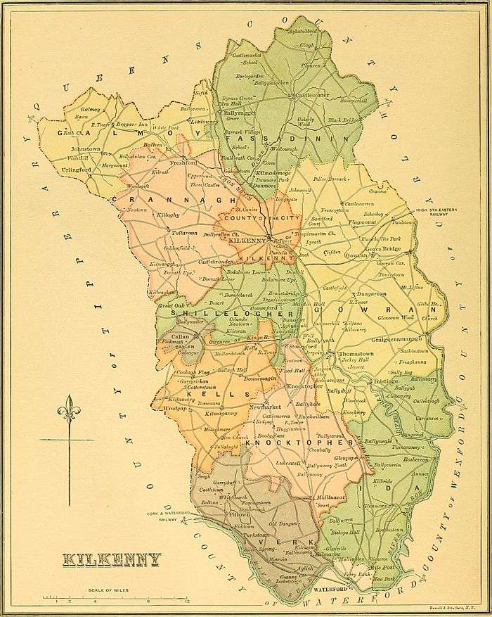
Iverk was part of the medieval Irish kingdom of Osraige. It was the territory of the Irish clan Uí Duach. In 1358 this Barony was known by its ancient name the "Cantred of Odoth".[4] The earliest reference to the barony was is 1587 where it was described as the barony of "Fasaghdenyn and Idoghe".[4]
The early Anglo-Norman records of "Overk in Ossory" included the present Barones of Iverk and Ida and the southern extremity of the barony of Knocktopher.[4][6] The territory of Uibh-Eirc was co-extensive with the present Barony of Iverk.[4]
Iverk was recorded in the Down Survey (1656),[7] and on Griffith's Valuation (1864).[8] Parts of the barony were in the Poor law unions of Carrick on Suir and Waterford.[2]
Territory of O Faolain (O'Phelan) and O'Dunphy.[9] Ballycastlane Cottage is located in Iverk.[10]
Geography
Iverk contains the towns of Pilltown, Kilmacow, Fiddown, Mooncoin and the settlements of Owning and Templeorum.[11]
Iverk contains the civil parishes of Aglish, Arderra, Ballytarsney, Clonmore, Fiddown, Kilmacow, Muckalee, Pollrone, Portnascully, Rathkieran, Tibberaghny, Tubbrid, Ullid, and Whitechurch.[12]
Fiddown Island [13] and the Poulanassy and Lingaun River are in Iverk.[14] It also contains a bogland called Moondeega.[15] There is a wood called Corbally Wood.[16]
See also
References
Footnotes
- 1 2 3 4 (Government 2003)
- 1 2 3 (Parliament 1862, p. 963, Iverk Barony)
- ↑ (Fiontar 2008, Uíbh Eirc/Iverk)
- 1 2 3 4 5 (Carrigan 1905, p. 19, Existing Civil Divisions or Baronies)
- ↑ (Tighe 1802, p. 4, Baronies)
- ↑ (RSA Journal 1893 pp181-183)
- ↑ Down Survey Project. "Iverk Map". downsurvey.tcd.ie. The Down Survey Project.
- ↑ (Griffith 1864, Iverk Search)
- ↑ Walsh, Dennis. "The Baronies of Ireland". ancestry.com. and Walsh, Dennis. "Barony Map of the Leinster Region". ancestry.com.
- ↑ (Fiontar 2008, Ballycastlane Cottage)
- ↑ (Fiontar 2008, Iverk Towns and Fiontar 2008, Iverk population centres)
- ↑ (Fiontar 2008, Iverk Civil Parishes)
- ↑ (Fiontar 2008, Fiddown Island)
- ↑ (Fiontar 2008, Iverk Rivers)
- ↑ (Fiontar 2008, Moondeega Bogland)
- ↑ (Fiontar 2008, Corbally Wood)
Sources
- Fiontar (2008). "Placenames Database of Ireland". logainm.ie. Department of Community, Rural and Gaeltacht Affairs of the Government of Ireland.
- Griffith (1864). "Griffith's Valuation". www.askaboutireland.ie.
- Government (2003). Placenames (Co. Kilkenny) Order 2003 (PDF). Dublin: Government of Ireland.
- Parliament (1862). General alphabetical index to townlands and towns, parishes and baronies of Ireland.
- Carrigan, William (1905). The History and Antiquities of the Diocese of Ossory. Sealy, Bryers & Walker. ISBN 9785879206463.
- Tighe, William (1802). Statistical observations relative to the county of Kilkenny: made in the years 1800 & 1801. Printed by Graisberry and Campbell.
External links
- Walsh, Dennis. "Barony of Iverk". ancestry.com.
- Walsh, Dennis. "The Baronies of Ireland". ancestry.com.
- Walsh, Dennis. "Barony Map of the Leinster Region". ancestry.com.
Places adjacent to Barony of Iverk | ||||||||||
|---|---|---|---|---|---|---|---|---|---|---|
| ||||||||||
|  | |
| ||