Bara Venecija
| Bara Venecija Бара Венеција | |
|---|---|
| Urban neighbourhood | |
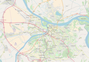 Bara Venecija Location within Belgrade | |
| Coordinates: 44°48′02″N 20°26′51″E / 44.80056°N 20.44750°ECoordinates: 44°48′02″N 20°26′51″E / 44.80056°N 20.44750°E | |
| Country |
|
| Region | Belgrade |
| Municipality | Savski Venac |
| Time zone | UTC+1 (CET) |
| • Summer (DST) | UTC+2 (CEST) |
| Area code | +381(0)11 |
| Car plates | BG |
Bara Venecija (Serbian Cyrillic: Бара Венеција) is an urban neighborhood of Belgrade, the capital of Serbia. It is located in Belgrade's municipality of Savski Venac, along the right bank of the Sava river.
Location
Bara Venecija is located on the right bank of the Sava river, roughly between the Old Sava bridge and Branko's Bridge some 700–800 meters (0.4–0.5 mi) west of Terazije, downtown Belgrade. It is basically a small sub-neighborhood of the Savamala, which used to cover much larger area.
History
The area was originally a bog called Ciganska bara (Serbian Cyrillic: Циганска бара, "Gypsy pond"). The bog was charted for the first time in an Austrian map from 1789. It was a marsh which covered a wide area from modern Karađorđeva street to the mouth of the Topčiderska reka into the Sava, across the northern tip of Ada Ciganlija. Marshy area covered modern location of the Belgrade Main railway station and parts of the Sarajevska and Hajduk-Veljkov venac streets. Ciganska bara drained two other bogs. One was located on Slavija, which drained through the creek of Vračarski potok[1] which flew down the area of the modern Nemanjina street. Other pond whose water drained into the Ciganska bara was Zeleni Venac. Romanies who lived in the area, used the mud from the bog to make roof tiles. They lived in small huts or caravans (called "čerge"), between the high grass and rush, with their horses and water buffaloes grazing freely in the area. As most of the huts were actually stilt houses, built on piles due to the marshy land, the area was gradually named Bara Venecija ("Venice pond"). By 1884 the bog was drained and buried under the rubble from all parts of the city and especially from Prokop, because of the construction of the Belgrade Main railway station.[2]
Characteristics
Bara Venecija is almost entirely industrial and commercial area. Many hangars and depots, asphalt plants and oil tanks are located here, due to the proximity of both downtown Belgrade and Sava harbor (Savsko pristanište). It all gives the neighborhood industrialized, unattractive, gray look.
Being on the lowest part of the Sava's bank, Bara Venecija gets flooded during the extremely high waters of the river. It was completely flooded in 1984 and during the major flood of 2006
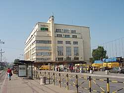
Just south of the railway station, there is a building of the Post Office No. 6. Originally built as the Post Office No. 2 in the 1920s, it was constructed by architect Miomir Korunović. Due to the extravagantly ornamented façade, it was called "architectural beauty" and considered one of the most beautiful buildings in Belgrade and among Korunović's best works. It was damaged during World War II and reconstructed later. However, the new, Communist authorities considered its façade "too bourgeois" so they removed the remains of the façade and reconstructed only the skeletal architecture under it, which suited the style of the Socialist realism which was pushed by the government in the immediate post-war period..[3]
References
- ↑ Dragana Jokić Stamenković (28 May 2011), "Beograd na dvesta sputanih voda", Politika (in Serbian)
- ↑ Dragoljub Acković (December 2008), "Šest vekova Roma u Beogradu – part XV, Veselje do kasno u noć", Politika (in Serbian)
- ↑ Dejan Aleksić (22 April 2018). "Zaboravljeni srpski Gaudi" [Forgotten Serbian Gaudi]. Politika (in Serbian).