Bannang Sata District
| Bannang Sata บันนังสตา | |
|---|---|
| Amphoe | |
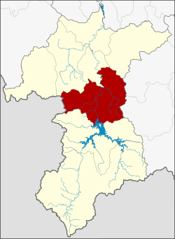 Amphoe location in Yala Province | |
| Coordinates: 6°16′0″N 101°15′52″E / 6.26667°N 101.26444°ECoordinates: 6°16′0″N 101°15′52″E / 6.26667°N 101.26444°E | |
| Country | Thailand |
| Province | Yala |
| Seat | Bannang Sata |
| Area | |
| • Total | 629.0 km2 (242.9 sq mi) |
| Population (2014) | |
| • Total | 58,616 |
| • Density | 84.5/km2 (219/sq mi) |
| Time zone | UTC+7 (ICT) |
| Postal code | 95130 |
| Geocode | 9503 |
Bannang Sata (Thai: บันนังสตา, pronounced [bān.nāŋ sā.tāː]; Malay: Benang Setar) is a district (amphoe) in the southern part of Yala Province, southern Thailand.
History
The name Bannang Sata is the Thai corruption of Benang Setar (Jawi: بنڠ ستار), its original Malay name. "Benang" means 'sewing thread', while "setar" is a 'tree with small, sour fruit' (Bouea macrophylla).[1]
In the past the district was named Ba Cho (บาเจาะ) controlled by Mueang Raman, created in 1907.[2] The name Ba Cho is a Thai corruption of Bachok (Jawi: باچوق), its original Malay name. Later, the district office was moved to a new location and renamed Bannang Sata.[3]
Geography
Neighboring districts are (from the northwest clockwise) Yaha, Krong Pinang, and Raman of Yala Province, Rueso and Si Sakhon of Narathiwat Province, Than To of Yala Province and Kedah state of Malaysia.
Administration
Central administration
Bannang Sata is divided into six sub-districts (tambon), which are further subdivided into 50 administrative villages (muban).
| No. | Name | Thai | Villages | Pop.[4] |
|---|---|---|---|---|
| 1. | Bannang Sata | บันนังสตา | 11 | 19,445 |
| 2. | Bacho | บาเจาะ | 5 | 8,318 |
| 3. | Tano Pute | ตาเนาะปูเต๊ะ | 10 | 9,741 |
| 4. | Tham Thalu | ถ้ำทะลุ | 5 | 2,998 |
| 5. | Taling Chan | ตลิ่งชัน | 13 | 13,879 |
| 6. | Khuean Bang Lang | เขื่อนบางลาง | 6 | 4,235 |
Local administration
There are two sub-district municipalities (thesaban tambon) in the district:
- Bannang Sata (Thai: เทศบาลตำบลบันนังสตา) consisting of parts of sub-district Bannang Sata.
- Khuean Bang Lang (Thai: เทศบาลตำบลเขื่อนบางลาง) consisting of sub-district Khuean Bang Lang.
There are five sub-district administrative organizations (SAO) in the district:
- Bannang Sata (Thai: องค์การบริหารส่วนตำบลบันนังสตา) consisting of parts of sub-district Bannang Sata.
- Bacho (Thai: องค์การบริหารส่วนตำบลบาเจาะ) consisting of sub-district Bacho.
- Tano Pute (Thai: องค์การบริหารส่วนตำบลตาเนาะปูเต๊ะ) consisting of sub-district Tano Pute.
- Tham Thalu (Thai: องค์การบริหารส่วนตำบลถ้ำทะลุ) consisting of sub-district Tham Thalu.
- Taling Chan (Thai: องค์การบริหารส่วนตำบลตลิ่งชัน) consisting of sub-district Taling Chan.
References
- ↑ Chote Suvatti (1938). A Check-list of Aquatic Fauna in Siam (excluding Fishes). Bureau of Fisheries. p. 81.
- ↑ "แจ้งความกระทรวงมหาดไทย เรื่อง ย้ายที่ว่าการอำเภอบาเจาะเมืองราห์มันไปตั้งที่ตำบลบันนังสตาขึ้นเมืองราห์มัน ย้ายที่ว่าการอำเภอเบตงตั้งที่บ้านชดาบ ส่วนที่ว่าการอำเภอเบตงในเวลานี้ให้ตั้งเป็นกิ่งอำเภอ" (PDF). Royal Gazette (in Thai). 24 (39): 1037–1038. 1907-12-29.
- ↑ "แจ้งความกระทรวงมหาดไทย เรื่อง ย้ายที่ว่าการอำเภอบาเจาะไปตั้งที่ตำบลบันนังสตาแล้ว ขอเปลี่ยนนามอำเภอบาเจาะว่าอำเภอบันนังสตา" (PDF). Royal Gazette (in Thai). 24 (52): 1405. 1908-03-29.
- ↑ "Population statistics 2014" (in Thai). Department of Provincial Administration. Retrieved 2015-05-20.