Balls Creek Campground
|
Balls Creek Campground | |
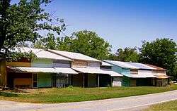 Balls Creek Campground, July 2010 | |
  | |
| Location | West side of SR 1003, 0.1 miles (0.16 km) south of SR 1943, near Bandy's Crossroads, North Carolina |
|---|---|
| Coordinates | 35°37′46″N 81°05′50″W / 35.62944°N 81.09722°WCoordinates: 35°37′46″N 81°05′50″W / 35.62944°N 81.09722°W |
| Area | 31.1 acres (12.6 ha) |
| MPS | Catawba County MPS |
| NRHP reference # | 90000662[1] |
| Added to NRHP | April 27, 1990 |
Balls Creek Campground is a historic Methodist camp meeting and national historic district located near Bandy's Crossroads, Catawba County, North Carolina. The district encompasses 138 contributing buildings and 1 contributing site. They include the Arbor (c. 1930), tents dating back to the 1850s, store or "The Shack" (c. 1940), and jail dated to the late-19th / early-20th century. The camp meeting was established in 1853 and is believed to be one of the largest religious campgrounds in the southern United States.[2]
It was added to the National Register of Historic Places in 1990.[1]
See also
References
- 1 2 National Park Service (2010-07-09). "National Register Information System". National Register of Historic Places. National Park Service.
- ↑ Barbara Kooiman and Michael Hill (July 1989). "Balls Creek Campground" (pdf). National Register of Historic Places - Nomination and Inventory. North Carolina State Historic Preservation Office. Retrieved 2014-08-01.
External links


This article is issued from
Wikipedia.
The text is licensed under Creative Commons - Attribution - Sharealike.
Additional terms may apply for the media files.