Ballintogher
| Ballintogher Baile an Tóchair | |
|---|---|
| Village | |
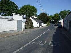 R290 road at Ballintogher | |
 Ballintogher Location in Ireland | |
| Coordinates: 54°12′04″N 8°21′54″W / 54.201°N 8.365°WCoordinates: 54°12′04″N 8°21′54″W / 54.201°N 8.365°W | |
| Country | Ireland |
| Province | Connacht |
| County | County Sligo |
| Elevation | 65 m (213 ft) |
| Population (2016)[1] | |
| • Total | 331 |
| Time zone | UTC+0 (WET) |
| • Summer (DST) | UTC-1 (IST (WEST)) |
| Irish Grid Reference | G760280 |
Ballintogher (Irish: Baile an Tóchair)[2] is a village in County Sligo, Ireland. It is located approximately 8 kilometers southeast of the county town of Sligo on the R290 road between Ballygawley to the west and Dromahair in County Leitrim to the north-east. Known as "The Town of the Causeway", Ballintogher is situated near Lough Gill, and the "Lake Isle of Innisfree" made famous by the poet W. B. Yeats.[3]
Ballintogher was located near the Sligo, Leitrim and Northern Counties Railway, which was begun in the 1870s and closed in 1957.[3]
References
- ↑ "Census 2016 Sapmap Area: Settlements Ballintogher". Central Statistics Office (Ireland). Retrieved 7 March 2018.
- ↑ "Baile an Tóchair / Ballintogher". Government of Ireland. Retrieved 27 June 2011.
- 1 2 "About Ballintogher". Aidan Burke and Enda McCormack. Archived from the original on 26 March 2012. Retrieved 27 June 2011.
Places in County Sligo | ||
|---|---|---|
| Towns | 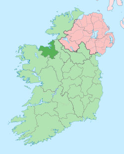 | |
| Villages and townlands |
| |
| Islands | ||
| ||
This article is issued from
Wikipedia.
The text is licensed under Creative Commons - Attribution - Sharealike.
Additional terms may apply for the media files.