Collooney
| Collooney Cúil Mhuine | |
|---|---|
| Town | |
 Main Street | |
 Collooney Location in Ireland | |
| Coordinates: 54°10′59″N 8°29′31″W / 54.183°N 8.492°WCoordinates: 54°10′59″N 8°29′31″W / 54.183°N 8.492°W | |
| Country | Ireland |
| Province | Connacht |
| County | County Sligo |
| Elevation | 62 m (203 ft) |
| Population (2016)[1] | |
| • Total | 1,610 |
| Time zone | UTC+0 (WET) |
| • Summer (DST) | UTC-1 (IST (WEST)) |
| Irish Grid Reference | G674261 |
Collooney or Coloony (Irish: Cúil Mhuine, meaning "nook of the thicket"[2]) is a town in County Sligo, Ireland.
Transport
Collooney is located just off the N4 (Dublin to Sligo) and N17 (Sligo to Galway) roads, having been bypassed twice, by the N4 in 1998, and the N17 in 1992, and is the meeting point of both roads.
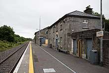
Sligo–Dublin line railway station
The town was a significant railway centre, with no less than four railway stations. In addition to the one remaining Collooney railway station, opened on 3 December 1862,[3] (on the railway from Dublin to Sligo) there was a station on the line to Claremorris (The Western Railway Corridor) and on the Sligo, Leitrim and Northern Counties Railway line to Enniskillen.
See also
External links
![]()
References
- ↑ "Population and Actual and Percentage Change 2011 to 2016". Central Statistics Office (Ireland). Retrieved 2017-12-03.
- ↑ "Cúil Mhuine/Collooney". Placenames Database of Ireland. Government of Ireland - Department of Arts, Heritage and the Gaeltacht and Dublin City University. Retrieved 2017-12-03.
- ↑ "Collooney station" (PDF). Railscot - Irish Railways. Retrieved 2007-09-07.
Places in County Sligo | ||
|---|---|---|
| Towns | 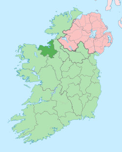 | |
| Villages and townlands |
| |
| Islands | ||
| ||
This article is issued from
Wikipedia.
The text is licensed under Creative Commons - Attribution - Sharealike.
Additional terms may apply for the media files.