Cloonacool
| Cloonacool Cluain na Cúile | |
|---|---|
| Town | |
 Cloonacool Location in Ireland | |
| Coordinates: 54°06′07″N 8°46′39″W / 54.1019°N 8.7775°WCoordinates: 54°06′07″N 8°46′39″W / 54.1019°N 8.7775°W | |
| Country | Ireland |
| Province | Connacht |
| County | County Sligo |
| Elevation | 67 m (220 ft) |
| Time zone | UTC+0 (WET) |
| • Summer (DST) | UTC-1 (IST (WEST)) |
| Irish Grid Reference | G491172 |
Cloonacool (Irish: Cluain na Cúile, meaning "The Meadow at the Back") is a village in County Sligo, Ireland. Cloonacool sits at the foot of the Ox Mountains, and this is where the name at the back comes from. The Mad river runs close to the village before it links up with the River Moy also running close to the village.
See also
Places in County Sligo | ||
|---|---|---|
| Towns | 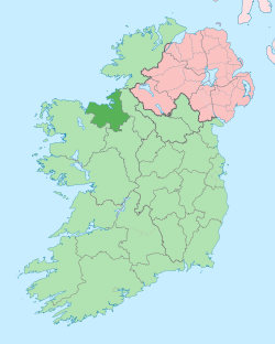 | |
| Villages and townlands |
| |
| Islands | ||
| ||
This article is issued from
Wikipedia.
The text is licensed under Creative Commons - Attribution - Sharealike.
Additional terms may apply for the media files.