Ballincollig
| Ballincollig Baile an Chollaigh | |
|---|---|
| Town | |
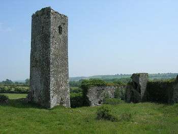 Ballincollig Castle | |
 Ballincollig Location in Ireland | |
| Coordinates: 51°53′16.54″N 8°35′21.44″W / 51.8879278°N 8.5892889°WCoordinates: 51°53′16.54″N 8°35′21.44″W / 51.8879278°N 8.5892889°W | |
| Country | Ireland |
| Province | Munster |
| County | County Cork |
| Dáil Éireann | Cork North-West |
| European Parliament constituency | South |
| Elevation | 70 ft (20 m) |
| Population (2016)[1][2] | |
| • Total | 18,621 |
| Time zone | UTC+0 (WET) |
| • Summer (DST) | UTC-1 (IST (WEST)) |
| Eircode (Routing Key) | P31 |
| Irish Grid Reference | W5957077 |
| Website |
ballincollig |

| Historical population | ||
|---|---|---|
| Year | Pop. | ±% |
| 1841 | 1,287 | — |
| 1851 | 789 | −38.7% |
| 1861 | 917 | +16.2% |
| 1871 | 524 | −42.9% |
| 1881 | 1,130 | +115.6% |
| 1891 | 836 | −26.0% |
| 1901 | 746 | −10.8% |
| 1911 | 815 | +9.2% |
| 1926 | 220 | −73.0% |
| 1936 | 260 | +18.2% |
| 1946 | 300 | +15.4% |
| 1951 | 986 | +228.7% |
| 1956 | 1,105 | +12.1% |
| 1961 | 1,151 | +4.2% |
| 1966 | 1,246 | +8.3% |
| 1971 | 2,110 | +69.3% |
| 1981 | 7,231 | +242.7% |
| 1986 | 10,522 | +45.5% |
| 1991 | 12,124 | +15.2% |
| 1996 | 13,288 | +9.6% |
| 2002 | 14,591 | +9.8% |
| 2006 | 15,760 | +8.0% |
| 2011 | 17,368 | +10.2% |
| 2016 | 18,621 | +7.2% |
| [3][4][5][6][7][1] | ||
Ballincollig (Irish: Baile an Chollaigh) is a satellite town and largest town in County Cork, Ireland, approximately 9 km west of Cork city. It is located beside the River Lee on the R608 regional road. In 2016 the population of the Ballincollig Electoral Division was 18,621.[1] The nearest towns include: Ballinora, Carrigrohane, Kilnaglory, Ovens, Killumney, Inniscarra, Blarney, and Tower. It is located beyond the Green Belt from the Cork city suburbs of Bishopstown and Wilton. Many people from Ballincollig commute to the city for work. It is a mainly residential town.

History
The Barrett family (after whom the barony which contains Ballincollig is named) built Ballincollig Castle during the reign of Edward III. The castle was taken from Andrew Barrett by rebels in 1641, but they were expelled by English Parliamentary forces under Murrough O'Brien, Earl Inchiquinn, in 1645. It was garrisoned for James II in 1689, during the Williamite war in Ireland, then remained unoccupied after his defeat, and fell into decay.
The Ballincollig Royal Gunpowder Mills were opened in 1794 by Charles Henry Leslie, a prominent Cork businessman. Eleven years later, the mills were bought by the British, who were preparing for war with Napoleon, and the barracks were built to protect the supply of gunpowder. It was one of the largest gunpowder mills in the British Isles. In 1837, the mill employed several hundred workers, and by 1880, Ballincollig was one of the largest industrial establishments in Cork, with the mill employing many men and boys from the area.
With the closure of the Gunpowder Mills in the early 1900s, Ballincollig became little more than a small village on the road from Cork city to the larger market town of Macroom. The 3rd Royal Munster Fusiliers (Reserve) Battalion were stationed there during the Great War. Other Regiments stationed in the Barracks before it was decommissioned were 1st Field Artillery Regiment and 8th Field Artillery Regiment (FCÁ). The recently decommissioned Murphy Barracks was a major source of employment. In the 1970s, Ballincollig developed as much more of a satellite town, with many housing developments constructed around the old village, and housing people who worked in Cork city or its suburbs. This expansion continued through the late 80s and 90s. Consequently, the town's population has risen dramatically, particularly with the westward expansion of the town. Ballincollig has grown to be largest town in the county.
Churches
Two Catholic churches are located in the town. The modern 'Church of Christ Our Light' (designed by a local architectural firm) is located on the west side of the town, while the old 'Church of St Mary and St John' is located near the centre of the town, on Station Road.[8]
The Bible Baptist Church meets in the Westgate Foundation on the west end of town. The church is associated with the Cork Bible Institute and other Gospel ministries.[9]
Other religious groups including Hindus, Sikhs, and Greek Orthodox also have services at various locations in Ballincollig.

Demographics
As of the 2011 census, Ballincollig was 87% Catholic, 7% other religions, 5% no religion, with 1% not stated. Ethnically, the town is 83% white Irish, 10% other white, 3% black, 2% Asian, 1% other, and 1% not stated.[10]
Amenities
The amenities located in Ballincollig include a library, a multiplex cinema, playgrounds, shopping centres[11] and the Ballincollig Regional Park.
The recreational park, Ballincollig Regional Park, includes the former gunpowder mill and measures approximately 135 acres (55 hectares), with 52 structures in varying stages of decay surviving from the gunpowder manufacturing process. The site is approximately 2.4 kilometres in length and the River Lee runs the northern length of the site. The site contains a system of canals used during the manufacturing process connecting all the process areas in a single flat system without locks. The canals are fed from the River Lee at the western end of the site. The park contains soccer pitches, a rugby pitch, walkways, a skateboard facility, and free-to-use outdoor fitness equipment - the latter installed on the park's western end in November 2011. As a result of a 2012 development plan, which outlined the future of the Regional Park by the Recreation & Amenity section of the local authority,[12] planning was approved for multi-use games areas and a children's playground. This work started December 2014 and is now completed. An eighty plot allotment scheme was also identified within the development plan,[12] and was opened in November 2013 at the Innishmore entrance to the Regional Park. A series of marked trails were laid-out in 2014, and consist of four looped walks, colour-coded according to length. The Military Trail begins at the Shopping Centre Square and continues to the Regional Park by a westerly route. Three other trails of varying lengths begin and end at the western end of the park - at Inniscarra Bridge.[13]

There is also another playground near the Lidl on the western side of the town.
Ballincollig is home to several crèches, four primary schools, and two secondary schools. The two secondary schools in Ballincollig are Coláiste Choilm and Ballincollig Community School. Ballincollig Community School is located in West Ballincollig and is next to the 'Church of Christ Our Light' and Scoil Barra (a primary school). Coláiste Choilm is located in East Ballincollig and is near a doctor's practice and the town centre of Ballincollig. Scoil Eoin and Scoil Mhuire (two primary schools) are located near St Mary's and St John's church. A new three-storey building was opened for Gaelscoil Uí Riordáin in 2012. This is one of two primary and secondary Gaelscoileanna (Irish-speaking schools) in the area, providing for a large number of pupils who learn through the Irish language in the area. It is one the eastern side of the town.[14]
There is a family entertainment center in the town, which has skating on a plastic surface and play areas. There are also shops, a shopping centre, restaurants and chain restaurants including Dinos, McDonald's, and Subway.
Places of interest
The Ballincollig Royal Gunpowder Mills along with its visitor centre / museum is to be found on the north side of the town. Some buildings in the Gunpowder Mills are now in disrepair but the area is still open to walkers in the Regional Park.
The grave of Rory Gallagher is located at St Oliver's Cemetery, on the Model Farm Road, just outside Ballincollig. His headstone is a replica of an award he received in 1972 for International Guitarist of The Year.
The Coolroe Lime Kiln is an example of the historic quarrying in the Coolroe area of the town.
Shops
There are many supermarkets in Ballincollig including a Dunnes, a Lidl, two Aldis, a Tesco and two Supervalus. There is also Ballincollig Shopping Centre, and there are many shops around the main street. There is also a weekly farmers market near the shopping centre.
Transport & communications
History
The Cork to Macroom rail line served Station House (at the south end of Station Road).
Ballincollig railway station was opened on 12 May 1866, closed to passenger traffic on 1 July 1935, closed to goods traffic on 10 March 1947 and finally closed altogether on 1 December 1953.[15]
Public transport
Ballincollig is served by a number of Bus Éireann bus routes. These include route 220 (to Carrigaline, via UCC, Cork City Centre, and Douglas), route 220A (similar to route 220, but continuing to Fountainstown), and route 233 (Cork City Centre to Macroom via Ballincollig).
A number of proposals, such as the 'Project Ireland 2040' transport plan, include a potential feasibility study into a possible suburban light rail project in the area.[16][17]
Road
Ballincollig was situated on the N22 from Cork to Tralee. A bypass around the town was opened in September 2004, which resulted in reduced journey times from Cork to Killarney on the N22 and reduced traffic volumes through the town centre. The N40 starts on the eastern side of the town that continues as the Cork southern bypass. The N40 and N22 both share exit 1.
The former alignment of the N22 is now the R608 regional road which goes through the town centre.
Air
The nearest airport is Cork Airport which is about 14 km away.
Notable people
- Mick Mannock, recipient of the Victoria Cross
- Horace de Vere Cole, noted prankster and organiser of the 1910 Dreadnought hoax
Clubs & sport
Active sports clubs in the town include: Ballincollig Athletic Club, Ballincollig Basketball Club, Ballincollig GAA Club, Belvedere Hockey Club, a soccer club,[18] Ballincollig RFC, table tennis club,[19] ultimate frisbee club, a boxing club, Muay Thai club,[20] and wrestling centre for young people.
Ballincollig is home to the 49th Cork Scout group.[21]
See also
| Wikimedia Commons has media related to Ballincollig. |
References
- 1 2 3 "Census 2016 Sapmap Area: Electoral Division Ballincollig". Census 2016. Central Statistics Office. Retrieved 6 October 2017.
- ↑ "Census 2016 results show Cork county population rose by 4.2%". The Corkman. Independent News & Media. 15 April 2017. Retrieved 6 October 2017.
- ↑ Census for post 1821 figures. Archived 20 September 2010 at the Wayback Machine.
- ↑ http://www.histpop.org Archived 7 May 2016 at the Wayback Machine.
- ↑ "Archived copy". Archived from the original on 17 February 2012. Retrieved 28 April 2014.
- ↑ Lee, JJ (1981). "Pre-famine". In Goldstrom, J. M.; Clarkson, L. A. Irish Population, Economy, and Society: Essays in Honour of the Late K. H. Connell. Oxford, England: Clarendon Press.
- ↑ Mokyr, Joel; O Grada, Cormac (November 1984). "New Developments in Irish Population History, 1700-1850". The Economic History Review. 37 (4): 473–488. doi:10.1111/j.1468-0289.1984.tb00344.x.
- ↑ Ballincollig Roman Catholic Parish
- ↑ Bible Baptist Church Ballincollig
- ↑ http://airo.maynoothuniversity.ie/external-content/cork-county-0
- ↑ Ballincollig County Cork Ireland Tourism Guide
- 1 2 "Ballincollig Regional Park Development Plan" (PDF). Cork County Council. June 2012. Archived from the original (PDF) on 22 February 2014.
- ↑ "Trails Map" (PDF). Cork County Council. June 2014. Archived from the original (PDF) on 23 January 2015.
- ↑ Enrolment at Gaelscoileanna and Gaelcholáistí
- ↑ "Ballincollig station" (PDF). Railscot - Irish Railways. Archived (PDF) from the original on 26 September 2007. Retrieved 2007-09-10.
- ↑ "Plans for Northern Ring Road and LUAS for Cork announced". Evening Echo. 16 February 2018.
- ↑ "Minutes of Proceedings at Meeting of Cork County Council 26 February 2007". Cork County Council. 26 February 2007. Archived from the original (DOC) on 18 December 2007.
- ↑ Ballincollig AFC/
- ↑ http://www.ballincolligttc.com/
- ↑ Spartan Thai Archived 25 April 2010 at the Wayback Machine.
- ↑ Ballincollig Parish website - Ballincollig Scout Unit Archived 24 March 2012 at the Wayback Machine.