Macroom
| Macroom Maigh Chromtha | |
|---|---|
| Town | |
 View of the Castle Arch and cannons | |
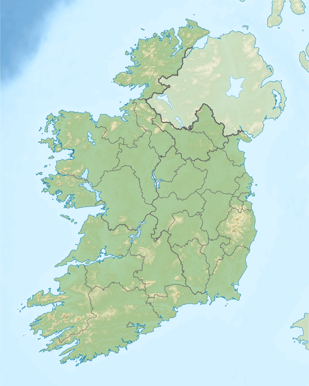 Macroom Location in Ireland  Macroom Macroom (Europe) | |
| Coordinates: 51°54′16″N 8°57′25″W / 51.904354°N 8.956947°WCoordinates: 51°54′16″N 8°57′25″W / 51.904354°N 8.956947°W | |
| Country | Ireland |
| Province | Munster |
| County | County Cork |
| Population (2016) | |
| • Total | 3,765 |
| Irish Grid Reference | W337729 |
| Website |
www |
Macroom (/məˈkruːm/; Irish: Maigh Chromtha) is a market town in County Cork, Ireland which formed in the valley of the River Sullane, about halfway between Cork city and Killarney. Its Irish Gaelic may translate as "meeting place of followers of the god Crom" or "crooked oak",[1] the latter a reference to a large oak tree that apparently grew in the town-square during the reign of the English King John.[2] Its population has grown and receded over the centuries as it went through periods of war, famine and workhouses, forced emigration and intermittent prosperity. In a 2011 census, the urban area was recorded as 3,879 people.
Macroom began as a meeting place for the Druids of Munster. It is first mentioned is in 6th-century records, and the immediate area hosted a major battle c. 987 involving the Irish king Brian Boru. During the middle ages, the town was invaded by a succession of warring clans, including the Murcheatach Uí Briain and Richard de Cogan families. In the early modern period the MacCarthy's took control and later the area found prosperity via milling. The MacCarthys built a series of tower houses, many of which survive. The family lost influence during the Williamite wars of the 1690s, after which authority over the town castle waxed and waned between the MacCarthys and a number of ambitious English families. In the 17th century, Macroom became a central point of conflict in the Cromwellian conquest of Ireland.
The population fell in the 1840s during the Great Irish Famine. Evidenced can be found in the former workhouse, now the district hospital at the north side of New Street, and the mass graveyard to the west, near Clondrohid. During the late 18th and early 19th century a number of Anglo-Irish families, and a branch of the Massey family, settled in the area; but many of their estate houses were burned by rebels during and after the Irish War of Independence as the town was caught the turmoil of IRA activity.
From 1976 to 1982 Macroom hosted the Mountain Dew Rock festival, with lineups that included Rory Gallagher, Thin Lizzy and Van Morrison, attended by Sex Pistol John Lydon. Today the town is an economic hub for the mid west Cork region, and host to a major Danone milk processing factory, which dries and cans Infant formula, from milk supplied by local dairy farmers.
History
Pre-Christian

Evidence of the human activity in the area survives from pre-history, especially the many iron age burial monuments; the area is unusually rich with standing stones, dolmens and stone circles.[3] Macroom seems to have been a centre for Bardic conventions and a base for the Druids of Munster.[4]
The first historical reference to Macroom dates from the 6th century, when the townland was known as Achad Dorbchon and held within the kingdom of Muscraighe Mitine.[5] The Eóganachta were then the dominant clan of Munster; they held kingdoms from Muscraighe Mitine to the midlands town of Birr. At some point, they were replaced by the Uí Floinn, who commissioned a castle in Macroom so as to establish Raithleann as capital of Muskerry.
Middle ages
Muscraighe Mitine underwent three invasions during the 13th century. The Murcheatach Uí Briain and Richard de Cogan arrived in 1201 and 1207 respectively; the MacCarthys became the dominant and most powerful family and held Macroom Castle until the mid-17th century.[6]
From the 14th century, Macroom became the capital of the Barony of Muskerry and the centre for trade, burial and religious worship. It was one of the earliest Irish milling centres, and from the end of the 16th century the town grew from a village to a functionally diverse urban centre. The locality grew outwards from the castle. The MacCarthys established the town as a centre for markets and fairs, and in 1620 a market house was built to the east of and facing the castle. The family introduced a plantation scheme which aimed to attract new agriculture and industrial techniques and methods to the area.
Modern period
By the mid-17th century English families owned approximately one-third of the town in value terms.[9] The Protestant families introduced butter making, a labour-intensive industry. The 1650 battle of Macroom was waged as part of the Cromwellian conquest of Ireland, when the English Parliamentarian force under Roger Boyle defeated an Irish Confederate force under David Roche. Bishop Boetius MacEgan, fighting on behalf of the MacCarthys, failed to hold the castle and was taken prisoner by the Cromwellian forces and hanged at Carrigadrohid.[10]
A 1750 tenement list details 134 buildings and 300 families, with a population ratio of 6 to 1 between Catholic and Protestants. The town had developed from a locality of mud cabins in the early 1660s to a linear shaped urban settlement of mainly thatched cabins, which were later replaced by solid cottages following a campaign by the Irish Land and Labour Association (ILLA). Macroom Castle was for a period controlled by Admiral Sir William Penn, a British Admiral and father of William Penn, after whom the U.S. state of Pennsylvania is named.
War of Independence

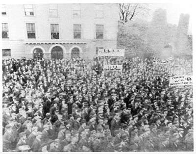
Macroom was the main base in Cork for the British Auxiliary Division during the 1919–1921 Irish War of Independence. The Irish Republican Army was highly active in the county, especially in the areas around Macroom, Bandon and Dunmanway. Royal Irish Constabulary police in the town described the area as "practically in a state of war". After a series of burnings of local police barracks and courthouses[11] a curfew was imposed on the town, with a ban on public meetings and market fairs. A local IRA member wrote of a "hinterland unpoliced and unwatched". The local police felt they had lost control and the Auxiliaries were called to intervene. The townspeople treated army personnel with hostility, and there were instances of patrols being stoned. The Brits were embroiled in a guerrilla battle in the Muskerry hills, coming under fire from the Ballyvourney IRA cell, and lost three men – two of them officers – in one attack.[12]
In 1920 at Kilmichael, on the road between Macroom and Dunmanway, 17 members of the Macroom Auxiliary "C Company" were ambushed and killed by a local IRA cell led by the prominent general Tom Barry. In the aftermath of the attack, the British military were given the power to execute anyone found carrying arms and ammunition, to search houses, impose curfews, try suspects in military rather than civilian courts and to intern suspects without trial. On 11 December, in reprisal, the centre of Cork city was burned by Auxiliaries, British soldiers and Black and Tans.[13]
Macroom Castle was burned out on five separate occasions; the last occasion was on 18 August 1922 following the evacuation of British Auxiliaries from the town. Members of anti-treaty forces, including Erskine Childers and Frank O'Connor, retreated from Cork City to Macroom, burning the castle before leaving.
Mount Massey, now ruined, was the 18th and 19th century home of the members of the Massey family, and is located north by Kilnagurteen and gave the townland of Masseytown its name. They family were major landowners with land covering 13,363 acres, extending from Clondrohid to Drishane. Later the home acted as was an auxiliary workhouse. It was laid siege and eventually burned in December 1920, during the War of Independence.[14]
The revolutionary soldier and politician Michael Collins was killed in 1922 in an ambush near Béal na Bláth. Lady Olivia Ardilaun, a descendant of the McCarthys, and widow of Lord Ardilaun, sold the castle demesne in 1924[15] to a group of local businessmen, which they put in trust for the town.
Geography
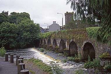
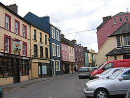
Macroom was built on the River Sullane, a tributary of the River Lee. Its hinterland lies on a valley at the foot of the Boggeragh Mountains. The town stretches for about 2 miles (3.2 km) and largely consists of two long streets, Main Street and New Street, divided by the Ten Arch Bridge, which also leads off to the suburb of Massey Town, further towards the village of Ballinagree and the Boggeragh Mountains.
Until the 1950s New Street was the town's economic hub, and contained many small retail outlets.
Climate
Like the rest of Ireland, the climate is temperate maritime, very even and heavily influenced by the North Atlantic Current, resulting in mild winters and cool summers.[16] Weather in Macroom is mild, usually warm, temperate and humid, with significant rainfall throughout the year, averaging at 1164 mm. Rain falls on average around 21 days of each month, peaking in December (average 24 days), and falling off slightly in June (average 21 days). Snow is uncommon; it tends to fall in January or February, for an average of 2–3 days per year. Wind speeds vary from c 80 km/hr avg in winter, to 50-52 in summer. The mean temperature is 10.1 °C.[17]
Economy

The economy is primarily agricultural lead. Local dairy farmers are members of Dairygold co-operative. Their milk is dried or evaporated in Mitchelstown as skim milk or whey concentrate, and eventually supplied to the local Danone plant, which produces infant formula for a worldwide market.
Tourism
Tourist attractions include the town centre, an 18-hole golf course, and the Castle Grounds, with fishing and golfing grounds. The town's surroundings contain large amounts of megalithic monuments, early Christian holy wells, churches and sacred sites associated with ancient visionaries and healers. Mushera Mountain is located a few kilometres to the north of the town, near Millstreet Country Park. It contains the ancient Saint John's Well. Carrigaphooca Castle, really a tower house, is 6 km west of the town, but no longer accessible to the public.
The Castle Arch, the centerpiece of the old castle grounds, admits walkers to the demesne parklands. It is still held in trust as a gift to, and possession of, the people of Macroom. This large park contains riverside walks among mature oak and beech trees. In early October it becomes an area of keen interest to mushroom enthusiasts. Macroom Oatmeal is milled here by the traditional stone-grinding process at Walton's Mill.
The Gearagh
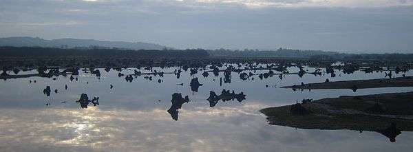
The Gearagh is a national nature reserve on an inland delta, is located 1.5 kilometres (0.93 mi) south of Macroom. It comprises a series of small islands, separated by anastomosing, mostly flat, river channels or streams,[18] and is bounded by Toon Bridge, Illaunmore, and Anahala Bridge. The area is thought to have been wooded since the end of the last Ice Age c. 8,000 bc.[19] The alluvial woodland extended as far as the Lee Bridge, and consisted of a large number of mature oak and ash trees.[20]
The reserve was gutted in 1954 when the Lee hydro-electric scheme led to extensive tree-felling and flooding. Now submerged houses are visible from the area around Two Mile Bridge. The scheme resulted in the loss of sixty percent of the former oak woodland.[19] Today, the Gearagh is of interest and importance due to its rich and rare diversity of wildlife, and represents the only extant extensive alluvial woodland in Western Europe.[21]
 Main pathway from the entrance
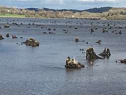 Submerged oak tree stumps, high water
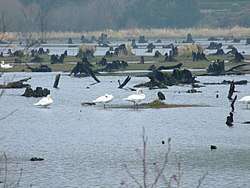 Swans resting on islands and tree stumps
Carrigaphooca Castle
Carrigaphooca Castle is a ruined five storey rectangular tower house situated on a steep-sided rock, 6 km west of Macroom. It was built as a defensive tower in 1436, probably by Donal McCarthy of Drishane.[22] In 1602, the castle was attacked and taken by Donal Cam O'Sullivan Beare.[23] During the 1970s, the Office of Public Works undertook restoration of the site, and added a flight of steps leading over the rock base, joining with the main entrance.[24] The ground floor chamber is lit by small off-center windows, and is flanked by a straight mural stairs which rises as a spiral to the 4th floor level.
The tower is located on private property and is no longer accessible to the public, although it is owned by the state.[25]
Mountain Dew festival
From 1976 to 1982 Macroom hosted the annual Mountain Dew festival, organised by young local business people. The festivals attracted up to 20,000 attendees each year. It was the first of its kind for Ireland, and was intended to reinvigorate a town that was then stagnant economically.[26] According to one of the organisers, Martin Fitzgerald, "The town needed a bit of shake rattle and roll to tempt not just international investors but Irish people to rest there a bit long...a rock concert fitted the bill".[27] Line ups included Rory Gallagher, Phil Lynott, Elvis Costello, Van Morrison, Marianne Faithfull and Horslips, and was attended by John Lydon of the Sex Pistols.[28]
Churches
The Roman Catholic church of St. Coleman's was built in 1841 and remodeled in 1893, based on a design by Dominic Coakley.[29] The Macroom Church of Ireland building was construed in 1823, on foot of a load of £1000 from the Board of Fruits. The building is now derelict, although the graveyard is still in use.[30] The remains of a thatched-chapel lies to the west of the town, on Lackaduduv mountain. A rare surviving form, the remnants are known locally as "Carrignaspirroge Chapel".[31]
Transport
Macroom is on the national primary route N22, approximately 38 km from Cork city and 48 km from Killarney. The nearest airport is Cork Airport.
A railway ran between the town and Cork city from 1866 to 1953, terminating in the mart grounds. By 1890 there were five services each way on week days and two on Sundays, with the running time taking just over an hour. Macroom railway station opened on 12 May 1866; it closed for passenger traffic on 1 July 1935 and for goods traffic on 10 March 1947, and was finally closed on 1 December 1953.[32]
Education
The town has two primaryl and three secondary schools; a De La Salle for boys, St. Mary's Secondary School Convent of Mercy for girls, and McEgan College, a mixed technical college located in the castle grounds.
The Convent of Mercy Secondary School is situated within the Sisters of Mercy's complex attached to St. Colman's Church, which also includes a convent, primary school, graveyard and grotto. Coláiste De La Salle was opened in 1933 and originally located in the town hall, until a permanent building was completed three years later. By the late 1970s the school was experiencing severe capacity issues and a re-structure and extension of the school was undertaken in 1982.[33] Since its opening the ratio of pupils has remained relatively stable with 40% coming from the town and the rest from surrounding parishes. A new building was built in 2008 for St Colman's Boys National School after years of planning applications and appeals.
Notable people
- Briege Corkery - winner of six All Ireland Senior Camogie medals between 2005-15
- Rena Buckley - the GAA's most decorated player in history, with 18 All-Ireland Medals.[34]
- Michael O'Leary (d. 1961) - recipient of the Victoria Cross
- John A. Murphy - historian, former senator, current Emeritus Professor of History at University College Cork[35]
- Donal Creed - late Fine Gael politician; MEP, Teachta Dála, Minister of State under Garret FitzGerald[36]
- Michael Creed - Minister for Agriculture, Food and the Marine
- Dermot Desmond - businessman and seventh-richest person in Ireland
- Ann Kelleher - vice President at Intel[37]
Gallery
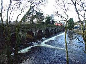 Bridge over the Sullane
 Morris's Bridge, Dromduff
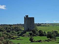 Carrigaphooca Castle, c. 1436 MacCarthy tower house
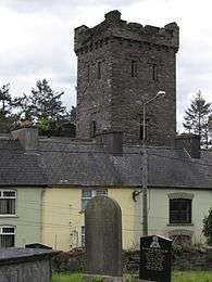 Street houses on bridge street, with old castle and Protestant graveyard in view
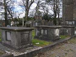 Graveyard in the derelict Protestant churchyard
 Bealick Mill, reconstructed in the 1990s, once housed the first public electrical generating station in Ireland
Sources
Notes
- ↑ It is one of many Irish place names derived from the name of the God Crom. (How & Parsons, 393)
- ↑ Lewis, Samuel. "Macroom, County Cork in Lewis Topographical Dictionary of Ireland 1837". Retrieved 2 January 2011. Google Books
- ↑ "Macroom: Town Profile Archived 2006-05-13 at the Wayback Machine.". agriculture.gov.ie. Retrieved on 19 March 2007.
- ↑ "History of Macroom". apieceofireland.com. Retrieved on 19 March 2007.
- ↑ Ring, 31
- ↑ Ring, 80
- ↑ "Lady Ardilaun Requests the Pleasure". theirishaesthete.com. Retrieved 22 July 2018
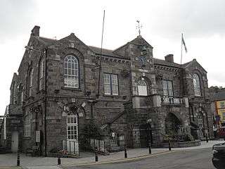
- ↑ "History of Macroom Town Hall Archived 2013-12-14 at the Wayback Machine.". Macroom UDC. Retrieved 14 December 2013
- ↑ Ring, 105
- ↑ Boetius MacEgan, Bishop of Ross Biography
- ↑ Hart, 27
- ↑ Hart, 28
- ↑ White & O'Shea, 9
- ↑ "Estate: Massy (Mount Massy)". NUI Galway. Retrieved 5 September 2015
- ↑ Keane, Barry. "Protestant Cork in decline 1911-1926; Murders, Mistakes, Myths, and Misinformation"
- ↑ "Macroom Climate History". weather2.com. Retrieved 25 February 2017
- ↑ "Climate: Macroom". Climate-Data.org. Retrieved 25 February 2017
- ↑ "The Gearagh". University College Cork. Retrieved on 19 March 2007
- 1 2 "The Gearagh". National Parks & Wildlife Service, 1997. Retrieved on 19 March 2007.
- ↑ O'Reilly, 279-286
- ↑ "The Gearagh ". Fáilte Ireland, 2004. Retrieved on 19 March 2007.
- ↑ Healy (1998), 27–29
- ↑ O Murchadah (1993), 223
- ↑ Power (1997), 361
- ↑ Heritage Unity of Cork County Council (2017), p. 96
- ↑ Crowley, Roz. "Macroom’s 'Mountain Dew' was Ireland's first rock festival". Irish Examiner, July 11, 2016. Retrieved August 21, 2016
- ↑ Roche, Barry. "Book marks 40th year of Macroom Mountain Dew Festival". Irish Times, June 15, 2016. Retrieved August 21, 2016
- ↑ Video footage exists. Power, Ed. "New book reveals John Lydon is Rotten at the core". Irish Examiner, October 31, 2014
- ↑ Cork County Council, 168
- ↑ Cork County Council, 166
- ↑ Cork County Council, 104
- ↑ "Macroom station" (PDF). Railscot - Irish Railways. Retrieved 2007-11-03.
- ↑ "Coláiste De La Salle". Retrieved on 19 March 2007.
- ↑ "Rena Buckley makes GAA history with an incredible 18 All-Ireland medals". The 42. 10 September 2017. Retrieved 3 January 2018.
- ↑ Roche, Barry. "John A Murphy: "I grew up speaking a language which is now extinct"". Irish Times, 8 November, 2014. Retrieved 29 July 2018
- ↑ O’Dea, Trish. "Farewell to a straight talker". The Independent, 17 June 2004. Retrieved 5 April 2015
- ↑ Roche, Barry. "IT executive urges girls to study science and technology". Irish Times, 26 November, 2015. Retrieved 29 July 2018
References
- Cope, Julian. The Modern Antiquarian. Thorsons, 1998. ISBN 978-07225-3599-8
- Hart, Peter M. The I.R.A. and Its Enemies: Violence and Community in Cork, 1916-1923. Oxford: Clarendon Press, 1999
- Heritage Castles of County Cork. Cork County Council, 2017. ISBN 978-09935-9693-3
- Heritage Churches of County Cork. Cork County Council, 2015. ISBN 978-09525-8692-0
- How and Parsons. "Ireland, its scenery, character, etc", 1841
- O'Reilly, H. "Survey of the Gearagh, an Area of Wet Woodland on the River Lee, near Macroom, Co. Cork". The Irish Naturalists' Journal, Vol. 11, No. 10, 1955. 279-286
- Ring, Denis Paul. A Historical Geography of Macroom C.500-1995. Castle House Publications, 1995.
- White, Gerry & O'Shea, Brendan. The Burning of Cork. Cork: Mercier Press, 2006.
External links
| Wikivoyage has a travel guide for Macroom. |
| Wikimedia Commons has media related to Macroom. |