Bad Lobenstein
| Bad Lobenstein | ||
|---|---|---|
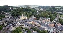
 Old town of Bad Lobenstein | ||
| ||
 Bad Lobenstein Location of Bad Lobenstein within Saale-Orla-Kreis district  | ||
| Coordinates: 50°27′0″N 11°39′0″E / 50.45000°N 11.65000°ECoordinates: 50°27′0″N 11°39′0″E / 50.45000°N 11.65000°E | ||
| Country | Germany | |
| State | Thuringia | |
| District | Saale-Orla-Kreis | |
| Government | ||
| • Mayor | Thomas Weigelt (Ind.) | |
| Area | ||
| • Total | 48.94 km2 (18.90 sq mi) | |
| Elevation | 560 m (1,840 ft) | |
| Population (2017-12-31)[1] | ||
| • Total | 5,997 | |
| • Density | 120/km2 (320/sq mi) | |
| Time zone | CET/CEST (UTC+1/+2) | |
| Postal codes | 07351–07356 | |
| Dialling codes | 036651 | |
| Vehicle registration | SOK | |
| Website | www.moorbad-lobenstein.de | |

Bad Lobenstein is a spa town in the Saale-Orla-Kreis district, in Thuringia, Germany with a population of about 6,000 inhabitants. Until 2005, the town was named Lobenstein.
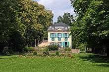
The town, grouped round a rock, upon which stand the ruins of an old castle, is exceedingly picturesque. It contains a spacious parish church, a palace (until 1824 the residence of the princes of Reuss-Lobenstein-Ebersdorf), and a hydropathic establishment. Local industries include dyeing, brewing and cigar-making.[2]
History
Within the German Empire (1871-1918), Lobenstein was part of the Principality of Reuss-Gera.
Coat of arms
Blazon: "In red floating the silver-black divided trunk of a bracke"
The trunk of the bracke (a certain type of dog group) is the crest of Principality of Reuss-Greiz (German: Fürstentum Reuß-Greiz). The image was already used in 15th century as coat of arms for the town.
Etymology
Lobenstein could come from "Lobe den Stein" which means "Praise the stone".
A legend describes how the inhabitants believe the town's name might have been established. It is believed that emperor Ludwig the Bavarian, who lived from 1328 to 1347 announced "Praise the stone" as he had lost and found his favourite dog in this region during hunting for deer. He was looking for the dog for quite a while until finally one of his knights found the tired and slightly injured dog lying on a stone. The knight caried the dog to his master, who was so grateful, he gave this piece of land as fief to the knight. In memory of this event, the place received the name Lobenstein and caried from now on the head of a bracke in its coat of arms.[3]
Geography
The town is located in the Thuringian Slate Mountains between Thuringian Forest and Franconian Forest, western to the Saale river dams Hohenwarte and Bleiloch next to Gräfenwarth.
Districts
- Bad Lobenstein, main district with town center
- Helmsgrün
- Lichtenbrunn
- Mühlberg
- Oberlemnitz
- Saaldorf
- Unterlemnitz
Neighbouring communities
- Gefell (in Thuringia)
- Saalburg-Ebersdorf
- Tanna
- Wurzbach
- Birkenhügel
- Harra
- Neundorf (bei Lobenstein)
- Remptendorf
- Schlegel
Incorporating communities
On 4 August 1993 previously independent municipalities Helmsgrün and Lichtenbrunn got incorporated into the community of Bad Lobenstein.[4] On 1 January 1997 also Unterlemnitz and in 1999 Oberlemnitz got in incorporated.[5]
Population growth
Demographic development (from 1994 on each number was counted on 31st December):
|
|
|
|
|
Data source from 1994: Thuringian State office for Statistics
Sights of Bad Lobenstein
- New Palace with Palace garden
- Castle Lobenstein (main landmark of the town)
- Town's church St. Michaelis
- Thermal bath
- "Markt Höhler" - a historical beer cellar which is located in the rocks below the city
- Regional Museum
- "Lommesteener Fäßlesächer" is a small figur located in the tower of the major hall, which is the mascot of Bad Lobenstein. It is hidden behind 2 doors and is visible several times a day.
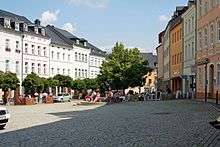
- Market place of Bad Lobenstein
Personality
Sons and daughters of the town
- Bad Lobenstein was the residence of the princes of Reuss-Lobenstein
- Heinrich Albert (composer) (1604-1651), composer
- Anton Friedrich Hohl (1789-1862), physician
- Hans Kollhoff (born 1946), architect
- Anja Rücker (born 1972), athlete; honorary citizen of the town of Bad Lobenstein since 1997
Other personalities
- Christian Gottlieb Reichard (1758-1837), councilor and general counsel to Lobenstein
- Georg Andreas Sorge (1703-1778), composer, 1721 court organist in Lobenstein.
- Axel Teichmann (born 1979), cross-country skier, visited here school and was appointed honorary citizen on May 2, 2003, due to his great sporting successes
References
- ↑ "Bevölkerung der Gemeinden, Gemeinschaftsfreie Gemeinde, erfüllende/beauftragende Gemeinden, Verwaltungsgemeinschaft/Mitgliedsgemeinden in Thüringen". Thüringer Landesamt für Statistik (in German). September 2018.
- ↑

- ↑ Arbeitsgemeinschaft Thüringen e.V. (Hrsg.): Neues Thüringer Wappenbuch. Band 2. Seite 39, 1998, ISBN 3-9804487-2-X
- ↑ Gemeinden 1994 und ihre Veränderungen seit 01.01.1948 in den neuen Ländern, Verlag Metzler-Poeschel, Stuttgart, 1995, ISBN 3-8246-0321-7, Herausgeber: Statistisches Bundesamt
- ↑ StBA: Änderungen bei den Gemeinden, siehe 1997 und 1999
| Wikimedia Commons has media related to Bad Lobenstein. |
| Authority control |
|---|