Babocomari River
| Babocomari River | |
|---|---|
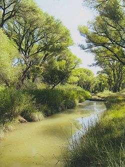 The Babocomari River in 2014. | |
| Country | United States |
| Location | Santa Cruz and Cochise Counties, Arizona |
| Physical characteristics | |
| Main source | Sonoita Basin |
| River mouth |
San Pedro River, Fairbank, Arizona 3,825 ft (1,166 m)[1] 31°43′20″N 110°11′38″W / 31.72222°N 110.19389°WCoordinates: 31°43′20″N 110°11′38″W / 31.72222°N 110.19389°W[1] |
| Length | 25 mi (40 km) |
| Basin features | |
| River system | Colorado River |
The Babocomari River is a major tributary of the upper San Pedro River in southeastern Arizona. The river begins in the Sonoita Basin near the community of Elgin, Arizona, and flows eastward for approximately twenty-five miles before merging with the San Pedro, just south of the Fairbank Historic Townsite in the San Pedro Riparian National Conservation Area. The Babocomari drains an area approximately 310 mi2, including the northern Huachuca Mountains, the northwestern Canelo Hills, and the southern Mustang Mountains, and is one of three drainages of the Sonoita Basin, the other two being Sonoita Creek and Cienega Creek. Vegetation consists of riparian trees along the main channel and small marshy grasslands.[2]
See also
References
- 1 2 U.S. Geological Survey Geographic Names Information System: Babocomari River
- ↑ Joseph P Cook Ann, et. al. (July 2009). "Mapping of Holocene River Alluvium along the San Pedro River Aravaipa Creek and Babocomari River Southeastern Arizona: Babocomari River Geology and Geomorphology" (PDF). Arizona Geological Survey. Retrieved 2014-12-12.
This article is issued from
Wikipedia.
The text is licensed under Creative Commons - Attribution - Sharealike.
Additional terms may apply for the media files.