Ludányhalászi
| Ludányhalászi | ||
|---|---|---|
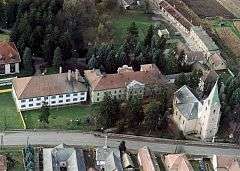 The Ráday palace and Church from above | ||
| ||
 Ludányhalászi Location of Ludányhalászi | ||
| Coordinates: 48°07′59″N 19°31′22″E / 48.13318°N 19.52281°E | ||
| Country |
| |
| County | Nógrád | |
| Subregion | Szécsényi | |
| Area | ||
| • Total | 21.20 km2 (8.19 sq mi) | |
| Population (2001) | ||
| • Total | 1,635 | |
| • Density | 77.12/km2 (199.7/sq mi) | |
| Time zone | UTC+1 (CET) | |
| • Summer (DST) | UTC+2 (CEST) | |
| Postal code | 3188 | |
| Area code(s) | 32 | |

Ludányhalászi is a village in Hungary, Nógrád county. It is the longest village in Central Europe.
External links
- Street map (in Hungarian)
Coordinates: 48°07′59″N 19°31′22″E / 48.13318°N 19.52281°E
This article is issued from
Wikipedia.
The text is licensed under Creative Commons - Attribution - Sharealike.
Additional terms may apply for the media files.