Azophi (crater)
 Lunar Orbiter 4 image of Azophi crater | |
| Coordinates | 22°06′S 12°42′E / 22.1°S 12.7°ECoordinates: 22°06′S 12°42′E / 22.1°S 12.7°E |
|---|---|
| Diameter | 47 km |
| Depth | 3.7 km |
| Colongitude | 348° at sunrise |
| Eponym | Al Sufi (Azophi) |
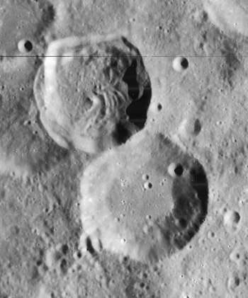
Azophi is a lunar impact crater that lies in the rugged south-central highlands of the Moon. The northwest rim is attached to the slightly smaller crater Abenezra, to the east-southeast is the large and irregular Sacrobosco, and to the west-southwest is the slightly crater Playfair.
The wide outer rim of Azophi has a somewhat polygonal shape with rounded corners. The edge is relatively sharp and cleft-like. The rim is not significantly worn or impacted by smaller craters, with the exception of Azophi C, which lies on the inner northeast wall. The interior floor lacks a central peak and is only marked by a few tiny craterlets.
Names
The crater is named after the 10th-century Persian astronomer Abd Al-Rahman Al Sufi, also known by his western name, Azophi, it was given its name by Giovanni Riccioli, whose 1651 nomenclature system has become standardized.[1][2] Earlier lunar cartographers had given the feature different names. Michael van Langren's 1645 map calls it "Mersenni",[1] his map were map slightly apart from the other crater which he called "Schyrlei", now Abenezra[3] And Johannes Hevelius called it "Antitaurus" after the mountains of the ancient world.[1][4]
Satellite craters
By convention these features are identified on lunar maps by placing the letter on the side of the crater midpoint that is closest to Azophi.
| Azophi | Latitude | Longitude | Diameter |
|---|---|---|---|
| A | 24.4° S | 11.2° E | 29 km |
| B | 23.6° S | 10.6° E | 19 km |
| C | 21.8° S | 13.1° E | 5 km |
| D | 24.3° S | 13.4° E | 9 km |
| E | 23.5° S | 13.8° E | 5 km |
| F | 22.2° S | 13.9° E | 6 km |
| G | 23.9° S | 12.3° E | 53 km |
| H | 25.5° S | 11.8° E | 21 km |
| J | 21.2° S | 13.1° E | 8 km |
See also
- 12621 Alsufi, asteroid named after Al Sufi (Azophi)
Notes
- 1 2 3 Ewen A. Whitaker, Mapping and Naming the Moon (Cambridge University Press, 1999).
- ↑ Riccioli map of the Moon (1651)
- ↑ Langrenus map of the Moon (1645)
- ↑ Hevelius map of the Moon (1647)
References
- Andersson, L. E.; Whitaker, E. A. (1982). NASA Catalogue of Lunar Nomenclature. NASA RP-1097.
- Blue, Jennifer (July 25, 2007). "Gazetteer of Planetary Nomenclature". USGS. Retrieved 2007-08-05.
- Bussey, B.; Spudis, P. (2004). The Clementine Atlas of the Moon. New York: Cambridge University Press. ISBN 978-0-521-81528-4.
- Cocks, Elijah E.; Cocks, Josiah C. (1995). Who's Who on the Moon: A Biographical Dictionary of Lunar Nomenclature. Tudor Publishers. ISBN 978-0-936389-27-1.
- McDowell, Jonathan (July 15, 2007). "Lunar Nomenclature". Jonathan's Space Report. Retrieved 2007-10-24.
- Menzel, D. H.; Minnaert, M.; Levin, B.; Dollfus, A.; Bell, B. (1971). "Report on Lunar Nomenclature by the Working Group of Commission 17 of the IAU". Space Science Reviews. 12 (2): 136–186. Bibcode:1971SSRv...12..136M. doi:10.1007/BF00171763.
- Moore, Patrick (2001). On the Moon. Sterling Publishing Co. ISBN 978-0-304-35469-6.
- Price, Fred W. (1988). The Moon Observer's Handbook. Cambridge University Press. ISBN 978-0-521-33500-3.
- Rükl, Antonín (1990). Atlas of the Moon. Kalmbach Books. ISBN 978-0-913135-17-4.
- Webb, Rev. T. W. (1962). Celestial Objects for Common Telescopes (6th revised ed.). Dover. ISBN 978-0-486-20917-3.
- Whitaker, Ewen A. (1999). Mapping and Naming the Moon. Cambridge University Press. ISBN 978-0-521-62248-6.
- Wlasuk, Peter T. (2000). Observing the Moon. Springer. ISBN 978-1-85233-193-1.
External links
| Wikimedia Commons has media related to Azophi (crater). |
Related article
- Wood, Chuck (January 5, 2007). "Sacrebleu, No Sacrobosco". Lunar Photo of the Day. Archived from the original on November 15, 2017.