Aliacensis (crater)
 Lunar Orbiter 4 image | |
| Coordinates | 30°36′S 5°12′E / 30.6°S 5.2°ECoordinates: 30°36′S 5°12′E / 30.6°S 5.2°E |
|---|---|
| Diameter | 79 km |
| Depth | 3.7 km |
| Colongitude | 356° at sunrise |
| Eponym | Pierre d'Ailly |
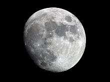
Aliacensis is a lunar impact crater that is located in the rugged southern highlands of the Moon. The crater Werner is located just to its north-northwest, and a narrow, rugged valley lies between the two comparably sized formations. To the southwest is Walther, and Apianus is to the northeast. It is from the Nectarian period, which lasted from 3.92 to 3.85 billion years ago.[1]
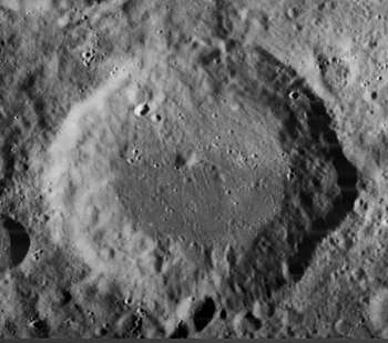
The rim of Aliacensis is generally circular, with an outward bulge on the eastern wall. The inner wall has some slight terracing particularly in the northeast. There is a small crater located across the southern rim. The interior floor is generally flat, with a low central peak slightly offset to the northwest of the midpoint. South of it lie two somewhat broken rings, Kaiser and Nonius. It is 52 kilometers in diameter and there is a 3.7 kilometer difference in height between its deepest part and its rim.[1][2]
Names
Aliacensis is named after the 14th century French geographer and theologian Pierre d'Ailly.[1] Like many of the craters on the Moon's near side, it was named by Giovanni Riccioli, whose 1651 nomenclature system has become standardized.[3] Earlier lunar cartographers had given the feature different names: Michael van Langren's 1645 map calls it "Elisabethae Palat. siliae", after Elizabeth of the Palatinate,[4] and Johannes Hevelius grouped it with Werner and Blanchinus under the name "Mons Antilibanus", after the Antilebanon Mountains.[5]
Satellite craters
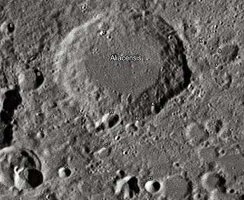
By convention these features are identified on lunar maps by placing the letter on the side of the crater midpoint that is closest to Aliacensis.[6]
| Aliacensis | Latitude | Longitude | Diameter |
|---|---|---|---|
| A | 29.7° S | 7.4° E | 14 km |
| B | 31.3° S | 3.2° E | 16 km |
| C | 32.6° S | 5.4° E | 8 km |
| D | 33.1° S | 6.9° E | 10 km |
| E | 30.4° S | 2.3° E | 9 km |
| F | 32.7° S | 3.9° E | 5 km |
| G | 33.3° S | 4.7° E | 8 km |
| H | 31.8° S | 6.1° E | 6 km |
| K | 31.4° S | 6.2° E | 7 km |
| W | 31.9° S | 5.3° E | 11 km |
| X | 29.6° S | 6.9° E | 4 km |
| Y | 30.1° S | 7.4° E | 5 km |
| Z | 30.0° S | 4.6° E | 4 km |
References
- 1 2 3 Autostar Suite Astronomer Edition. CD-ROM. Meade, April 2006.
- ↑ Moore, Patrick (2001). On the Moon. Sterling Publishing Co.. ISBN 0-304-35469-4.
- ↑ Ewen A. Whitaker, Mapping and Naming the Moon (Cambridge University Press, 1999), p. 214.
- ↑ Ewen A. Whitaker, Mapping and Naming the Moon (Cambridge University Press, 1999), p. 197.
- ↑ Ewen A. Whitaker, Mapping and Naming the Moon (Cambridge University Press, 1999), p. 205.
- ↑ Bussey, B.; Spudis, P. (2004). The Clementine Atlas of the Moon. New York: Cambridge University Press. ISBN 0-521-81528-2.
| Wikimedia Commons has media related to Aliacensis (crater). |