Agios Dimitrios
| Agios Dimitrios Άγιος Δημήτριος | |
|---|---|
 | |
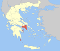
 Agios Dimitrios Location within the region  | |
| Coordinates: 37°56′N 23°44′E / 37.933°N 23.733°ECoordinates: 37°56′N 23°44′E / 37.933°N 23.733°E | |
| Country | Greece |
| Administrative region | Attica |
| Regional unit | South Athens |
| Area | |
| • Municipality | 4.949 km2 (1.911 sq mi) |
| Elevation | 60 m (200 ft) |
| Population (2011)[1] | |
| • Municipality | 71,294 |
| • Municipality density | 14,000/km2 (37,000/sq mi) |
| Time zone | UTC+2 (EET) |
| • Summer (DST) | UTC+3 (EEST) |
| Postal code | 173 xx |
| Area code(s) | 210 |
| Vehicle registration | Z |
| Website | www.dad.gr |
Agios Dimitrios (Greek: Άγιος Δημήτριος meaning Saint Dimitrios, before 1928: Μπραχάμι - Brachami[2]) is a suburb in the southern part of the Athens agglomeration, Greece.
Geography
Agios Dimitrios is situated 5 km south of Athens city centre, and 4 km from the Saronic Gulf coast. The municipality has an area of 4.949 km2.[3] Vouliagmenis Avenue connects it with central Athens and the southern suburbs. The suburb is connected with Line 2 of the Athens Metro through Alexandros Panagoulis station.
Historical population
| Year | Population |
|---|---|
| 1981 | 51,421 |
| 1991 | 57,574 |
| 2001 | 65,173 |
| 2011 | 71,294 |
Sports
The most important clubs based in Agios Dimitrios is the football club Agios Dimitrios F.C. and the basketball club Cronus Agios Dimitrios.
| Sport clubs based in Agios Dimitrios | |||
|---|---|---|---|
| Club | Founded | Sports | Achievements |
| Agios Dimitrios F.C. | 1928 | Football | Presence in Gamma Ethniki |
| Cronus Agios Dimitrios | 1976 | Basketball | Earlier presence in A1 Ethniki women |
Twinnings
References
- ↑ "Απογραφή Πληθυσμού - Κατοικιών 2011. ΜΟΝΙΜΟΣ Πληθυσμός" (in Greek). Hellenic Statistical Authority.
- ↑ Name changes of settlements in Greece
- ↑ "Population & housing census 2001 (incl. area and average elevation)" (PDF) (in Greek). National Statistical Service of Greece. Archived from the original (PDF) on 2015-09-21.
This article is issued from
Wikipedia.
The text is licensed under Creative Commons - Attribution - Sharealike.
Additional terms may apply for the media files.
