Avery Township, Humboldt County, Iowa
| Avery Township | |
|---|---|
| Township | |
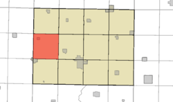 Location in Humboldt County | |
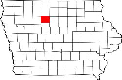 Humboldt County's location in Iowa | |
| Coordinates: 42°56′49″N 93°33′43″W / 42.947°N 93.562°WCoordinates: 42°56′49″N 93°33′43″W / 42.947°N 93.562°W | |
| Country |
|
| State |
|
| County | Humboldt |
| Area | |
| • Total | 36.2 sq mi (94 km2) |
| • Land | 35.8 sq mi (93 km2) |
| • Water | 0.4 sq mi (1 km2) |
| Elevation | 1,142 ft (348 m) |
| Population (2000) | |
| • Total | 316 |
| Time zone | UTC-6 (CST) |
| • Summer (DST) | UTC-5 (CDT) |
| ZIP codes | 50520 (Bradgate) |
| GNIS feature ID | 0467405 |
Avery Township is one of twelve townships in Humboldt County, Iowa, USA. As of the 2000 census, its population was 316.
History
Avery Township was organized in 1873. It is named for O. F. Avery, a pioneer settler.[1]
Geography
According to the United States Census Bureau, Avery Township covers an area of 36.2 square miles (94 km2); of this, 35.8 square miles (93 km2) is land and 0.4 square miles (1.0 km2) is water.
Cities, towns, villages
Adjacent townships
- Wacousta Township (north)
- Delana Township (northeast)
- Rutland Township (east)
- Corinth Township (southeast)
- Weaver Township (south)
- Lake Township, Pocahontas County (southwest)
- Garfield Township, Pocahontas County (west)
- Des Moines Township, Pocahontas County (northwest)
Cemeteries
The township does not contain any cemeteries.
Political districts
- Iowa's 4th congressional district
- State House District 4
References
- United States Census Bureau 2008 TIGER/Line Shapefiles
- United States Board on Geographic Names (GNIS)
- United States National Atlas
- ↑ History of Kossuth and Humboldt Counties, Iowa. Union Publishing Company. 1884. pp. 718–721. Note that Google Books misspells "Humboldt".
External links
Places adjacent to Avery Township, Humboldt County, Iowa | |
|---|---|
Municipalities and communities of Humboldt County, Iowa, United States | ||
|---|---|---|
| Cities | ||
| Townships | ||
| Unincorporated community | ||
| Ghost town | ||
| Footnotes | ‡This populated place also has portions in an adjacent county or counties | |
This article is issued from
Wikipedia.
The text is licensed under Creative Commons - Attribution - Sharealike.
Additional terms may apply for the media files.