Quebec Autoroute 440 (Quebec City)
| ||||
|---|---|---|---|---|
|
Autoroute Charest Autoroute Dufferin-Montmorency | ||||
 | ||||
| Route information | ||||
| Maintained by Transports Québec | ||||
| Length | 12.5 km (7.8 mi) | |||
| Existed | 1962[2] – present | |||
| Major junctions | ||||
| West end |
| |||
|
| ||||
| East end |
| |||
| Location | ||||
| Major cities | Sainte-Foy, Québec, Beauport | |||
| Highway system | ||||
| ||||

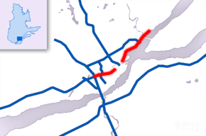
Autoroute 440 (or A-440) is a superhighway located in Quebec City. It includes two separate segments, respectively named Autoroute Charest and Autoroute Dufferin-Montmorency. Originally meant to be connected and form a single continuous highway via a tunnel under the city centre (unused ramps were torn down at the western terminus of the Dufferin-Montmorency section in the late 2000s), these plans were shelved years ago and are not expected to be revived.
The designation of Autoroute Charest is likely derived from Boulevard Charest, which is the street continuation east of this segment of A-440.
Route description
The Autoroute Charest segment is 4.5 km (2.8 mi) long. It begins at the junction of A-73 and A-40 and ends at Saint-Sacrement Avenue. Originally built as a two-lane freeway in 1962, it was twinned in 1967.
The roadway continues as Boulevard Charest into downtown Quebec, where A-440 traffic is directed along Rue Monseigneur-Gauvreau to reach the Autoroute Dufferin-Montmorency at its westernmost interchange (exit 21).
The Autoroute Dufferin-Montmorency is 8 km (5.0 mi) long. It begins at Route 175 (Corner of Avenue Dufferin and Côte d'Abraham) and ends at the junction with A-40 in Beauport. The portion from Route 175 to Boulevard Henri-Bourassa. (Exit 23) was built in 1976 and the rest of the segment (Exits 23 to 29) was built in 1982.
The autoroute was designated Dufferin-Montmorency because it extends former Avenue Dufferin (now Avenue Honoré-Mercier) in Quebec City and ends near the Montmorency Falls in Beauport. Lord Dufferin was a Governor General of Canada and had significant ties to Quebec City.
Exit list
The entire route is located in Québec City, Capitale-Nationale.
| km | mi | Exit | Destinations | Notes | |||
|---|---|---|---|---|---|---|---|
| 0.00 | 0.00 | – | |||||
| 12 | Westbound exit and eastbound entrance; signed as exits 12S (south) and 12N (north) | ||||||
| 15 | Exit 4 on A-740 | ||||||
| – | Rue Cyrille-Duquet / Rue Frank-Carrel / Boulevard Charest east | At-grade intersection | |||||
| Gap in route; connection made via Boulevard Charest | |||||||
| 21 | |||||||
| 22 | Boulevard des Capucins / Boulevard Champlain (Route 136) | ||||||
| 23 | Boulevard Henri-Bourassa | ||||||
| 24 | Avenue d'Estimauville | Eastbound exit is part of exit 23 | |||||
| – | Boulevard François-de-Laval – Beauport | At-grade intersection | |||||
| 27 | Boulevard des Chutes / Rue du Manège | ||||||
| 29 | Eastbound exit and westbound entrance | ||||||
| – | Exit 323 on A-40 | ||||||
| 1.000 mi = 1.609 km; 1.000 km = 0.621 mi | |||||||
References
- ↑ Ministère des transports, "Distances routières", page (?), Les Publications du Québec, 2005
- 1 2 "Répertoire des autoroutes du Québec" (in French). Transports Québec. Archived from the original on 2010-01-11. Retrieved 2008-02-23.
External links
Route map:
| Wikimedia Commons has media related to Quebec Autoroute 440 (Quebec City). |
- A-440 at Quebec Autoroutes
- Transports Quebec Map (in French)